Property Record
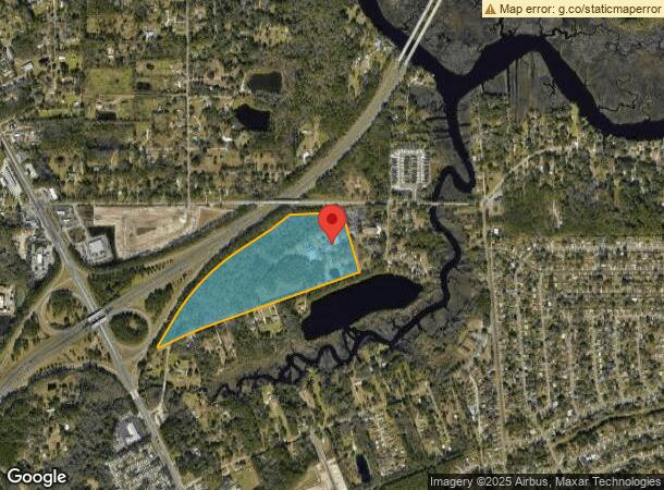
9840 Wagner Rd, Jacksonville, FL 32219
NEARBY LISTINGS FOR SALE OR LEASE
Property Detail
9840 Wagner Rd
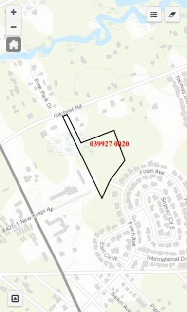
039927-0000
Section Land
Religious
42-1S-26E 41.953 I CARTER DONATION PT RECD O/R 7559-1166
X
Duval
12031C0186J
Florida
0
40.55 AC
2024
Northwest Jacksonville
010700
Jacksonville (Florida)
66,255 SF
Jacksonville, FL
DEMOGRAPHICS near 9840 Wagner Rd
1 Mile
3 Mile
5 Mile
2024 Total Population
5,777
40,752
102,363
2029 Population
6,123
42,979
108,336
Pop Growth 2024-2029
+ 5.99%
+ 5.46%
+ 5.84%
Average Age
42
40
39
2024 Total Households
2,279
15,284
38,693
HH Growth 2024-2029
+ 6.14%
+ 5.56%
+ 5.96%
Median Household Inc
$49,166
$47,765
$43,989
Avg Household Size
2.50
2.60
2.60
2024 Avg HH Vehicles
2.00
2.00
2.00
Median Home Value
$150,245
$158,850
$147,167
Median Year Built
1972
1972
1971
Nearby Places
- Restaurants
- Banks
- Shops
- Fitness
- Groceries
PUBLIC TRANSPORTATION
COMMUTER RAIL
Jacksonville (Silver Meteor - Amtrak, Silver Star - Amtrak)
DRIVE
WALK
Distance
Jacksonville (Silver Meteor - Amtrak, Silver Star - Amtrak)
10 min
4.3 mi
AIRPORT
Jacksonville International
DRIVE
WALK
Distance
Jacksonville International
21 min
10.9 mi
Freight Ports
Jacksonville Port
DRIVE
WALK
Distance
Jacksonville Port
21 min
10.5 mi
SALE & LEASE HISTORY
LISTING DATE
SALE/LEASE

Aug 08, 2018
For Sale
Apr 04, 2018
For Sale
Nearby Properties
Address
Land Use
TOTAL SIZE
Lot Size
Zoning
Address
Land Use
TOTAL SIZE
Lot Size
Zoning
647,378 SF
27.72 AC
IBP
Address
Land Use
TOTAL SIZE
Lot Size
Zoning
491,247 SF
30.77 AC
PUD
Address
Land Use
TOTAL SIZE
Lot Size
Zoning
449,967 SF
23.08 AC
IL
Address
Land Use
TOTAL SIZE
Lot Size
Zoning
284,023 SF
25.30 AC
RMD-C
Address
Land Use
TOTAL SIZE
Lot Size
Zoning
375,130 SF
25.22 AC
IBP
Address
Land Use
TOTAL SIZE
Lot Size
Zoning
744.81 AC
PUD
Address
Land Use
TOTAL SIZE
Lot Size
Zoning
302,066 SF
15.70 AC
IL
Address
Land Use
TOTAL SIZE
Lot Size
Zoning
277,582 SF
16.49 AC
IL
Address
Land Use
TOTAL SIZE
Lot Size
Zoning
1,265.67 AC
PUD
Address
Land Use
TOTAL SIZE
Lot Size
Zoning
254,693 SF
40.76 AC
RMD-D
Address
Land Use
TOTAL SIZE
Lot Size
Zoning
225,829 SF
140.47 AC
PBF-1
Address
Land Use
TOTAL SIZE
Lot Size
Zoning
171,572 SF
10.47 AC
PUD
Address
Land Use
TOTAL SIZE
Lot Size
Zoning
39,251 SF
55.24 AC
PUD
Address
Land Use
TOTAL SIZE
Lot Size
Zoning
178,080 SF
9.34 AC
IL
Address
Land Use
TOTAL SIZE
Lot Size
Zoning
157,948 SF
9.22 AC
PUD
Address
Land Use
TOTAL SIZE
Lot Size
Zoning
392,885 SF
61.13 AC
PBF-1
Address
Land Use
TOTAL SIZE
Lot Size
Zoning
192,086 SF
14.62 AC
RMD-D
Address
Land Use
TOTAL SIZE
Lot Size
Zoning
80,622 SF
78.47 AC
PUD
Address
Land Use
TOTAL SIZE
Lot Size
Zoning
95,080 SF
9.35 AC
CRO
Address
Land Use
TOTAL SIZE
Lot Size
Zoning
238,052 SF
30.81 AC
RHD-A
Address
Land Use
TOTAL SIZE
Lot Size
Zoning
79,407 SF
15.21 AC
PUD
Address
Land Use
TOTAL SIZE
Lot Size
Zoning
80,905 SF
14.86 AC
PUD
Address
Land Use
TOTAL SIZE
Lot Size
Zoning
49,120 SF
89.32 AC
CCG-2
Address
Land Use
TOTAL SIZE
Lot Size
Zoning
236,585 SF
35.65 AC
PBF-1
Address
Land Use
TOTAL SIZE
Lot Size
Zoning
64,432 SF
5.62 AC
PUD
Address
Land Use
TOTAL SIZE
Lot Size
Zoning
1,688 SF
99.78 AC
IH
Address
Land Use
TOTAL SIZE
Lot Size
Zoning
46.49 AC
PUD
Address
Land Use
TOTAL SIZE
Lot Size
Zoning
67,409 SF
12.53 AC
PUD
Address
Land Use
TOTAL SIZE
Lot Size
Zoning
13,214 SF
1.52 AC
PUD
The World's #1 Commercial Real Estate Marketplace
Connect with us
© 2025 CoStar Group
The information above has been obtained from sources believed reliable. While we do not doubt its accuracy we have not verified it and make no guarantee, warranty or representation about it. It is your responsibility to independently confirm its accuracy and completeness. Any projections, opinions, assumptions, or estimates used are for example only and do not represent the current or future performance of the property. The value of this transaction to you depends on tax and other factors which should be evaluated by your tax, financial, and legal advisors. You and your advisors should conduct a careful, independent investigation of the property to determine to your satisfaction the suitability of the property for your needs.