Property Record
9899 Sam Neace Dr, Florence, KY 41042
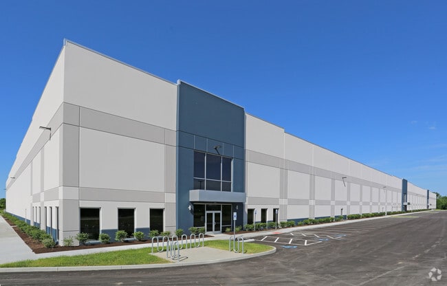

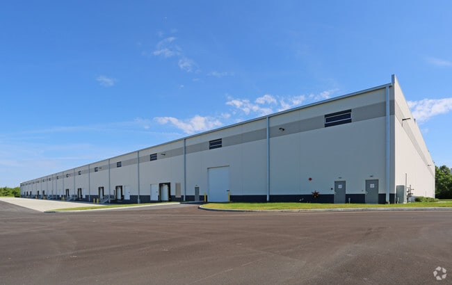
Property Detail
9899 Sam Neace Dr
Cincinnati, OH-KY-IN
LOT 10 PH C PART 2 AND RESUB OF PH C PART 1 LOT 10 US 25 INDUSTRIAL PARK (17.777 AC)
074.00-06-010.00
BOONE
Publicstorage
Kentucky
A Areas with a 1% annual chance of flooding and a 26% chance of flooding over the life of a 30-year mortgage.
10
2025
17.78 AC
2025
Florence/Richwood
070301
Cincinnati/Dayton
NEARBY LISTINGS FOR SALE OR LEASE
DEMOGRAPHICS near 9899 Sam Neace Dr
1 mile
3 mile
5 mile
2025 Total Population
5,747
68,055
146,547
2030 Population
6,080
71,582
153,586
Pop Growth 2025-2030
+ 5.79%
+ 5.18%
+ 4.80%
Average Age
36
38
39
2025 Total Households
2,343
25,496
54,562
HH Growth 2025-2030
+ 5.68%
+ 5.29%
+ 4.85%
Median Household Inc
$67,193
$74,328
$84,416
Avg Household Size
2.40
2.60
2.60
2025 Avg HH Vehicles
2.00
2.00
2.00
Median Home Value
$233,369
$242,748
$259,912
Median Year Built
1995
1993
1992
Nearby Places
Map Layers
Map Styles
 Street
 Aerial
Layers
 Traffic
 Biking
Places
Listings with unknown addresses are not visible on the map
- Restaurants
- Banks
- Shops
- Fitness
- Groceries
PUBLIC TRANSPORTATION
AIRPORT
Cincinnati/Northern Kentucky International
Drive
Walk
Distance
Cincinnati/Northern Kentucky International
20 min
9.0 mi
Freight Ports
Port of Toledo
Drive
Walk
Distance
Port of Toledo
261 min
221.0 mi
SALE & LEASE HISTORY
LISTING DATE
SALE/LEASE

Jul 26, 2017
For Lease
Nearby Properties
Address
Land Use
TOTAL SIZE
Lot Size
Zoning
Address
Land Use
TOTAL SIZE
Lot Size
Zoning
672.11 AC
Address
Land Use
TOTAL SIZE
Lot Size
Zoning
Address
Land Use
TOTAL SIZE
Lot Size
Zoning
70.34 AC
Address
Land Use
TOTAL SIZE
Lot Size
Zoning
80.59 AC
Address
Land Use
TOTAL SIZE
Lot Size
Zoning
96.46 AC
Address
Land Use
TOTAL SIZE
Lot Size
Zoning
19.61 AC
Address
Land Use
TOTAL SIZE
Lot Size
Zoning
73,908 SF
94.57 AC
Address
Land Use
TOTAL SIZE
Lot Size
Zoning
Address
Land Use
TOTAL SIZE
Lot Size
Zoning
1,170 SF
41.17 AC
Address
Land Use
TOTAL SIZE
Lot Size
Zoning
775,680 SF
44.84 AC
Address
Land Use
TOTAL SIZE
Lot Size
Zoning
32,250 SF
27.69 AC
Address
Land Use
TOTAL SIZE
Lot Size
Zoning
Address
Land Use
TOTAL SIZE
Lot Size
Zoning
1,824 SF
7.68 AC
Address
Land Use
TOTAL SIZE
Lot Size
Zoning
243,922 SF
14.77 AC
Address
Land Use
TOTAL SIZE
Lot Size
Zoning
27.21 AC
Address
Land Use
TOTAL SIZE
Lot Size
Zoning
14.47 AC
Address
Land Use
TOTAL SIZE
Lot Size
Zoning
112 SF
41.40 AC
Address
Land Use
TOTAL SIZE
Lot Size
Zoning
107,125 SF
12.49 AC
Address
Land Use
TOTAL SIZE
Lot Size
Zoning
19,542 SF
16.64 AC
Address
Land Use
TOTAL SIZE
Lot Size
Zoning
21.50 AC
Address
Land Use
TOTAL SIZE
Lot Size
Zoning
24.28 AC
Address
Land Use
TOTAL SIZE
Lot Size
Zoning
39.05 AC
Address
Land Use
TOTAL SIZE
Lot Size
Zoning
4.62 AC
Address
Land Use
TOTAL SIZE
Lot Size
Zoning
Address
Land Use
TOTAL SIZE
Lot Size
Zoning
17.20 AC
Address
Land Use
TOTAL SIZE
Lot Size
Zoning
20,320 SF
10.33 AC
Address
Land Use
TOTAL SIZE
Lot Size
Zoning
1,540 SF
19.04 AC
Address
Land Use
TOTAL SIZE
Lot Size
Zoning
78,848 SF
6.82 AC
Address
Land Use
TOTAL SIZE
Lot Size
Zoning
17.16 AC
Address
Land Use
TOTAL SIZE
Lot Size
Zoning
16.21 AC
The World's #1 Commercial Real Estate Marketplace
Connect with us
© 2026 CoStar Group
The information above has been obtained from sources believed reliable. While we do not doubt its accuracy we have not verified it and make no guarantee, warranty or representation about it. It is your responsibility to independently confirm its accuracy and completeness. Any projections, opinions, assumptions, or estimates used are for example only and do not represent the current or future performance of the property. The value of this transaction to you depends on tax and other factors which should be evaluated by your tax, financial, and legal advisors. You and your advisors should conduct a careful, independent investigation of the property to determine to your satisfaction the suitability of the property for your needs.