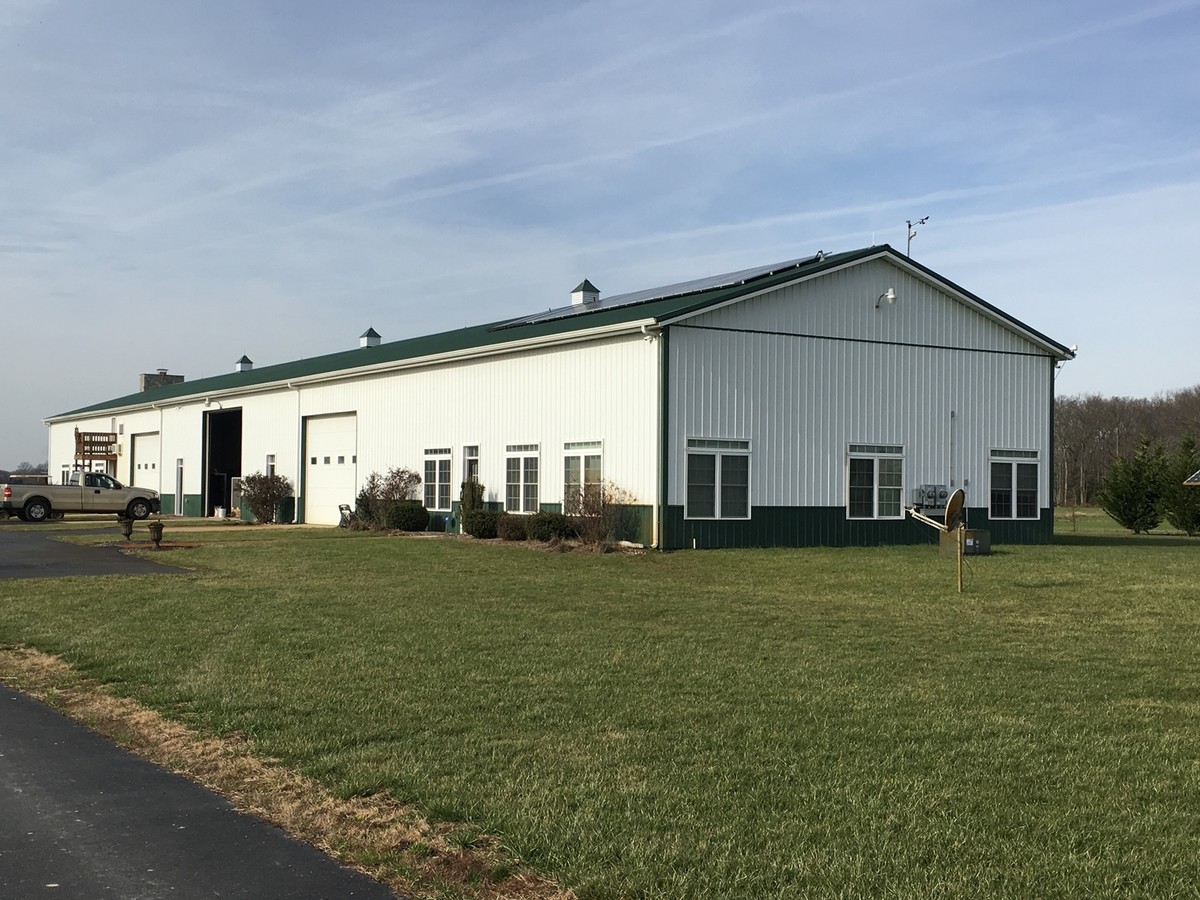
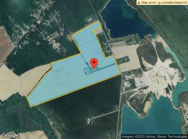
Property Record
999 Long Point Rd, Dover, DE 19901
NEARBY LISTINGS FOR SALE OR LEASE
Property Detail
999 Long Point Rd
4-05-06900-01-0600-000
Liule Creek Hundred
Farms
PAR. 3-W. SD. RD. #341, 115.03 A.
AE
Kent
10001C0186J
Delaware
2023
115 AC
2024
Kent County
041000
Philadelphia
9,900 SF
Dover, DE
DEMOGRAPHICS near 999 Long Point Rd
1 Mile
3 Mile
5 Mile
2024 Total Population
248
19,267
55,197
2029 Population
267
20,615
59,217
Pop Growth 2024-2029
+ 7.66%
+ 7.00%
+ 7.28%
Average Age
37
37
38
2024 Total Households
102
7,863
21,112
HH Growth 2024-2029
+ 7.84%
+ 7.19%
+ 7.56%
Median Household Inc
$49,166
$48,499
$55,094
Avg Household Size
2.30
2.30
2.40
2024 Avg HH Vehicles
2.00
1.00
2.00
Median Home Value
$163,888
$180,273
$236,219
Median Year Built
1986
1978
1984
Nearby Places
- Restaurants
- Banks
- Shops
- Fitness
- Groceries
SALE & LEASE HISTORY
LISTING DATE
SALE/LEASE

Sep 25, 2016
For Lease
Nearby Properties
Address
Land Use
TOTAL SIZE
Lot Size
Zoning
Address
Land Use
TOTAL SIZE
Lot Size
Zoning
12.10 AC
IO
Address
Land Use
TOTAL SIZE
Lot Size
Zoning
Address
Land Use
TOTAL SIZE
Lot Size
Zoning
1,360 SF
181.50 AC
RC
Address
Land Use
TOTAL SIZE
Lot Size
Zoning
189,363 SF
123.90 AC
IO
Address
Land Use
TOTAL SIZE
Lot Size
Zoning
172,440 SF
28.86 AC
RM2
Address
Land Use
TOTAL SIZE
Lot Size
Zoning
5,151.20 AC
AC
Address
Land Use
TOTAL SIZE
Lot Size
Zoning
322,096 SF
18.20 AC
SC2
Address
Land Use
TOTAL SIZE
Lot Size
Zoning
105,846 SF
15.79 AC
SC2
Address
Land Use
TOTAL SIZE
Lot Size
Zoning
379,358 SF
67.30 AC
SC3
Address
Land Use
TOTAL SIZE
Lot Size
Zoning
116,604 SF
3.20 AC
IO
Address
Land Use
TOTAL SIZE
Lot Size
Zoning
187,104 SF
7.80 AC
RM1
Address
Land Use
TOTAL SIZE
Lot Size
Zoning
Address
Land Use
TOTAL SIZE
Lot Size
Zoning
78 AC
CPO
Address
Land Use
TOTAL SIZE
Lot Size
Zoning
72,794 SF
11.57 AC
IO
Address
Land Use
TOTAL SIZE
Lot Size
Zoning
Address
Land Use
TOTAL SIZE
Lot Size
Zoning
111,744 SF
11.47 AC
RG2
Address
Land Use
TOTAL SIZE
Lot Size
Zoning
113,226 SF
2.50 AC
IO
Address
Land Use
TOTAL SIZE
Lot Size
Zoning
105,470 SF
6.90 AC
IO
Address
Land Use
TOTAL SIZE
Lot Size
Zoning
168,550 SF
22.40 AC
IO
Address
Land Use
TOTAL SIZE
Lot Size
Zoning
Address
Land Use
TOTAL SIZE
Lot Size
Zoning
55,272 SF
11.30 AC
IO
Address
Land Use
TOTAL SIZE
Lot Size
Zoning
79,447 SF
3.18 AC
C4
Address
Land Use
TOTAL SIZE
Lot Size
Zoning
6,336 SF
52.20 AC
MHP
Address
Land Use
TOTAL SIZE
Lot Size
Zoning
199,272 SF
8.50 AC
RG1
Address
Land Use
TOTAL SIZE
Lot Size
Zoning
74,521 SF
15.90 AC
IO
Address
Land Use
TOTAL SIZE
Lot Size
Zoning
463.40 AC
AC
Address
Land Use
TOTAL SIZE
Lot Size
Zoning
94,576 SF
10.74 AC
SC2
Address
Land Use
TOTAL SIZE
Lot Size
Zoning
Address
Land Use
TOTAL SIZE
Lot Size
Zoning
97,489 SF
8.69 AC
SC2
Address
Land Use
TOTAL SIZE
Lot Size
Zoning
23,122 SF
8.90 AC
SC1
The World's #1 Commercial Real Estate Marketplace
Connect with us
© 2025 CoStar Group
The information above has been obtained from sources believed reliable. While we do not doubt its accuracy we have not verified it and make no guarantee, warranty or representation about it. It is your responsibility to independently confirm its accuracy and completeness. Any projections, opinions, assumptions, or estimates used are for example only and do not represent the current or future performance of the property. The value of this transaction to you depends on tax and other factors which should be evaluated by your tax, financial, and legal advisors. You and your advisors should conduct a careful, independent investigation of the property to determine to your satisfaction the suitability of the property for your needs.