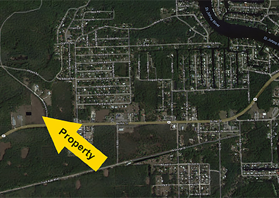
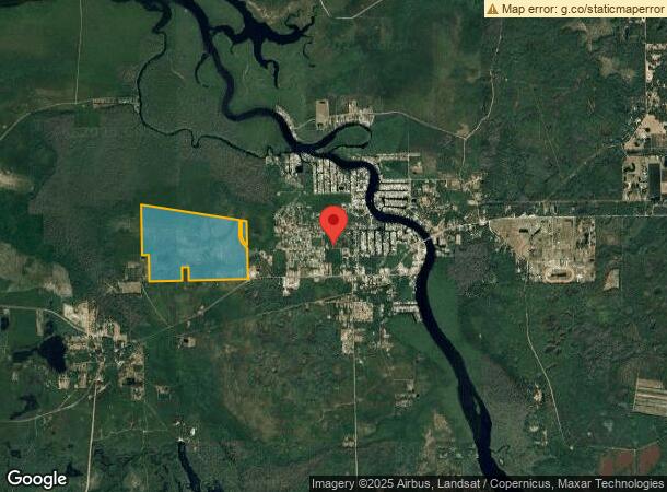
Property Record
Airport Rd, Astor, FL 32102
NEARBY LISTINGS FOR SALE OR LEASE
-
-
View all Astor listings for sale on LoopNet.com
Property Detail
Airport Rd
Orlando-Kissimmee-Sanford, FL
Manhattan
07-15-27-0200-000-04100
MANHATTAN SEC 2 LOTS 41 42 43 44 49 TO 56 INCL 58 59 61 62 63 64 E 1/2 OF LOTS 57 60 N 1/2 OF W 1/2 OF LOT 60 PB 2 PG 13 ORB 691 PG 107
Vacantlandnec
Lake
A
Florida
12127C0275H
41
0
387.93 AC
2024
Lake County
030102
Orlando
DEMOGRAPHICS near Airport Rd
1 Mile
3 Mile
5 Mile
2024 Total Population
979
3,526
4,025
2029 Population
1,180
4,161
4,728
Pop Growth 2024-2029
+ 20.53%
+ 18.01%
+ 17.47%
Average Age
49
48
48
2024 Total Households
428
1,554
1,771
HH Growth 2024-2029
+ 20.33%
+ 17.82%
+ 17.33%
Median Household Inc
$54,565
$51,560
$51,696
Avg Household Size
2.20
2.20
2.20
2024 Avg HH Vehicles
2.00
2.00
2.00
Median Home Value
$175,567
$214,314
$222,048
Median Year Built
1982
1980
1980
Nearby Places
- Restaurants
- Banks
- Shops
- Fitness
- Groceries
PUBLIC TRANSPORTATION
AIRPORT
Daytona Beach International
DRIVE
WALK
Distance
Daytona Beach International
52 min
36.2 mi
Freight Ports
Port Canaveral
DRIVE
WALK
Distance
Port Canaveral
125 min
98.4 mi
SALE & LEASE HISTORY
LISTING DATE
SALE/LEASE

Nov 08, 2021
For Sale
Nearby Properties
Address
Land Use
TOTAL SIZE
Lot Size
Zoning
Address
Land Use
TOTAL SIZE
Lot Size
Zoning
605.83 AC
A
Address
Land Use
TOTAL SIZE
Lot Size
Zoning
491.13 AC
A
Address
Land Use
TOTAL SIZE
Lot Size
Zoning
639.34 AC
A
Address
Land Use
TOTAL SIZE
Lot Size
Zoning
18,998 SF
2.33 AC
B7
Address
Land Use
TOTAL SIZE
Lot Size
Zoning
397.63 AC
A
Address
Land Use
TOTAL SIZE
Lot Size
Zoning
637.73 AC
A
Address
Land Use
TOTAL SIZE
Lot Size
Zoning
641.17 AC
A
Address
Land Use
TOTAL SIZE
Lot Size
Zoning
626.60 AC
A
Address
Land Use
TOTAL SIZE
Lot Size
Zoning
384.69 AC
A
Address
Land Use
TOTAL SIZE
Lot Size
Zoning
4,806.35 AC
A
Address
Land Use
TOTAL SIZE
Lot Size
Zoning
589.68 AC
A
Address
Land Use
TOTAL SIZE
Lot Size
Zoning
632.83 AC
A
Address
Land Use
TOTAL SIZE
Lot Size
Zoning
594.69 AC
A
Address
Land Use
TOTAL SIZE
Lot Size
Zoning
571.72 AC
A
Address
Land Use
TOTAL SIZE
Lot Size
Zoning
560.44 AC
A
Address
Land Use
TOTAL SIZE
Lot Size
Zoning
563.26 AC
A
Address
Land Use
TOTAL SIZE
Lot Size
Zoning
23,264 SF
2.46 AC
CFD
Address
Land Use
TOTAL SIZE
Lot Size
Zoning
490.38 AC
A
Address
Land Use
TOTAL SIZE
Lot Size
Zoning
3,812 SF
19.24 AC
01B7
Address
Land Use
TOTAL SIZE
Lot Size
Zoning
14,088 SF
7.10 AC
01B7
Address
Land Use
TOTAL SIZE
Lot Size
Zoning
416.10 AC
A
Address
Land Use
TOTAL SIZE
Lot Size
Zoning
1,105.55 AC
A
Address
Land Use
TOTAL SIZE
Lot Size
Zoning
403.32 AC
A
Address
Land Use
TOTAL SIZE
Lot Size
Zoning
210 AC
A
Address
Land Use
TOTAL SIZE
Lot Size
Zoning
28.42 AC
A2
Address
Land Use
TOTAL SIZE
Lot Size
Zoning
715.31 AC
FR
Address
Land Use
TOTAL SIZE
Lot Size
Zoning
625.80 AC
A
Address
Land Use
TOTAL SIZE
Lot Size
Zoning
8,400 SF
446.22 AC
A
Address
Land Use
TOTAL SIZE
Lot Size
Zoning
690.54 AC
FR
The World's #1 Commercial Real Estate Marketplace
Connect with us
© 2025 CoStar Group
The information above has been obtained from sources believed reliable. While we do not doubt its accuracy we have not verified it and make no guarantee, warranty or representation about it. It is your responsibility to independently confirm its accuracy and completeness. Any projections, opinions, assumptions, or estimates used are for example only and do not represent the current or future performance of the property. The value of this transaction to you depends on tax and other factors which should be evaluated by your tax, financial, and legal advisors. You and your advisors should conduct a careful, independent investigation of the property to determine to your satisfaction the suitability of the property for your needs.