Property Record
9845 Fortson Dr, Fort Mill, SC 29707
This Property Is For Sale
NEARBY LISTINGS FOR SALE OR LEASE
Property Detail
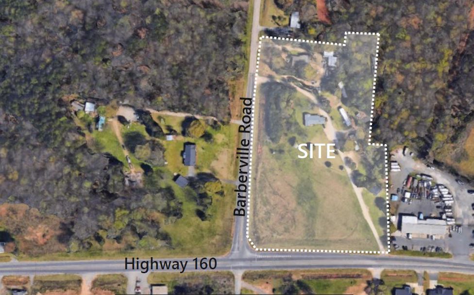
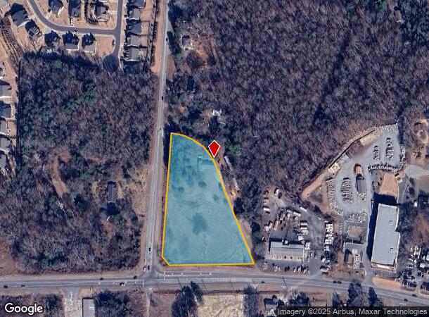
9845 Fortson Dr
Charlotte-Concord-Gastonia, NC-SC
Boundary And Subdivision Survey For Vall
0006-00-073.00
Lancaster
Sfr
South Carolina
X
3.89 AC
45057C0020E
Lancaster County
1,230 SF
Charlotte
DEMOGRAPHICS near 9845 Fortson Dr
1 Mile
3 Mile
5 Mile
2024 Total Population
3,808
43,969
121,751
2029 Population
4,585
50,903
136,332
Pop Growth 2024-2029
+ 20.40%
+ 15.77%
+ 11.98%
Average Age
37
38
38
2024 Total Households
1,331
15,975
45,141
HH Growth 2024-2029
+ 20.36%
+ 15.87%
+ 12.09%
Median Household Inc
$123,246
$114,222
$109,113
Avg Household Size
2.90
2.70
2.70
2024 Avg HH Vehicles
2.00
2.00
2.00
Median Home Value
$373,953
$389,451
$394,263
Median Year Built
2010
2008
2005
Nearby Places
- Restaurants
- Banks
- Shops
- Fitness
- Groceries
PUBLIC TRANSPORTATION
AIRPORT
Charlotte/Douglas International
DRIVE
WALK
Distance
Charlotte/Douglas International
33 min
18.0 mi
Concord-Padgett Regional
DRIVE
WALK
Distance
Concord-Padgett Regional
52 min
35.5 mi
Freight Ports
North Charleston Terminal
DRIVE
WALK
Distance
North Charleston Terminal
211 min
186.0 mi
Nearby Properties
Address
Land Use
TOTAL SIZE
Lot Size
Zoning
Address
Land Use
TOTAL SIZE
Lot Size
Zoning
348,409 SF
26.08 AC
R17MFCD
Address
Land Use
TOTAL SIZE
Lot Size
Zoning
211,609 SF
6.91 AC
UR2CD
Address
Land Use
TOTAL SIZE
Lot Size
Zoning
53,788 SF
18.86 AC
Address
Land Use
TOTAL SIZE
Lot Size
Zoning
182,180 SF
7.31 AC
MX2
Address
Land Use
TOTAL SIZE
Lot Size
Zoning
176,078 SF
11.42 AC
MX
Address
Land Use
TOTAL SIZE
Lot Size
Zoning
61,916 SF
13 AC
RB
Address
Land Use
TOTAL SIZE
Lot Size
Zoning
131,863 SF
4.52 AC
Address
Land Use
TOTAL SIZE
Lot Size
Zoning
120,698 SF
5.18 AC
Address
Land Use
TOTAL SIZE
Lot Size
Zoning
54,397 SF
10.91 AC
PDD
Address
Land Use
TOTAL SIZE
Lot Size
Zoning
73,104 SF
20.51 AC
O-1(CD)
Address
Land Use
TOTAL SIZE
Lot Size
Zoning
52,491 SF
5.91 AC
MX
Address
Land Use
TOTAL SIZE
Lot Size
Zoning
86,368 SF
11.28 AC
NS
Address
Land Use
TOTAL SIZE
Lot Size
Zoning
75,139 SF
11.89 AC
PDD
Address
Land Use
TOTAL SIZE
Lot Size
Zoning
74,604 SF
2.26 AC
Address
Land Use
TOTAL SIZE
Lot Size
Zoning
94,220 SF
13.49 AC
LI
Address
Land Use
TOTAL SIZE
Lot Size
Zoning
228.10 AC
MX-1(INNOV
Address
Land Use
TOTAL SIZE
Lot Size
Zoning
278,324 SF
23.89 AC
LI
Address
Land Use
TOTAL SIZE
Lot Size
Zoning
80,614 SF
6.83 AC
MX-2
Address
Land Use
TOTAL SIZE
Lot Size
Zoning
108,195 SF
28.29 AC
INS
Address
Land Use
TOTAL SIZE
Lot Size
Zoning
3,187 SF
182.31 AC
R-3
Address
Land Use
TOTAL SIZE
Lot Size
Zoning
68,300 SF
10.10 AC
B1CD
Address
Land Use
TOTAL SIZE
Lot Size
Zoning
29,760 SF
7.47 AC
Address
Land Use
TOTAL SIZE
Lot Size
Zoning
30,564 SF
3.08 AC
MX
Address
Land Use
TOTAL SIZE
Lot Size
Zoning
61,867 SF
3.98 AC
UR2CD
Address
Land Use
TOTAL SIZE
Lot Size
Zoning
60,000 SF
10 AC
PDD
Address
Land Use
TOTAL SIZE
Lot Size
Zoning
51,633 SF
1.44 AC
UR2CD
Address
Land Use
TOTAL SIZE
Lot Size
Zoning
32,543 SF
4.64 AC
Address
Land Use
TOTAL SIZE
Lot Size
Zoning
50,388 SF
6.46 AC
MX
Address
Land Use
TOTAL SIZE
Lot Size
Zoning
71,872 SF
2.37 AC
NS
Address
Land Use
TOTAL SIZE
Lot Size
Zoning
49,023 SF
18.73 AC
R3
The World's #1 Commercial Real Estate Marketplace
Connect with us
© 2025 CoStar Group
The information above has been obtained from sources believed reliable. While we do not doubt its accuracy we have not verified it and make no guarantee, warranty or representation about it. It is your responsibility to independently confirm its accuracy and completeness. Any projections, opinions, assumptions, or estimates used are for example only and do not represent the current or future performance of the property. The value of this transaction to you depends on tax and other factors which should be evaluated by your tax, financial, and legal advisors. You and your advisors should conduct a careful, independent investigation of the property to determine to your satisfaction the suitability of the property for your needs.