Property Record
Bellaire Blvd, Houston, TX 77083
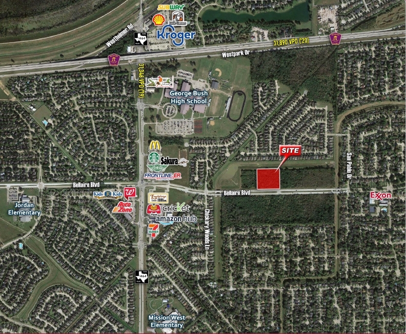
This Property Is For Sale
NEARBY LISTINGS FOR SALE OR LEASE
Property Detail
Bellaire Blvd
Houston-The Woodlands-Sugar Land, TX
T T R R
0422-00-000-0325-907
0422 T T R R, TRACT 5, ACRES 2.989
Commercialacreage
Fort Bend
X
Texas
48157C0135L
5
2023
2.99 AC
2023
E Fort Bend Co/Sugar Land
454000
Houston
DEMOGRAPHICS near Bellaire Blvd
1 Mile
3 Mile
5 Mile
2024 Total Population
17,805
114,107
324,437
2029 Population
20,478
129,086
364,235
Pop Growth 2024-2029
+ 15.01%
+ 13.13%
+ 12.27%
Average Age
37
36
37
2024 Total Households
5,216
35,097
104,130
HH Growth 2024-2029
+ 15.41%
+ 13.06%
+ 11.95%
Median Household Inc
$68,855
$67,622
$72,147
Avg Household Size
3.30
3.20
3.00
2024 Avg HH Vehicles
2.00
2.00
2.00
Median Home Value
$181,714
$229,726
$260,315
Median Year Built
1988
1999
2000
Nearby Places
- Restaurants
- Banks
- Shops
- Fitness
- Groceries
PUBLIC TRANSPORTATION
AIRPORT
William P Hobby
DRIVE
WALK
Distance
William P Hobby
46 min
29.1 mi
George Bush Intcntl/Houston
DRIVE
WALK
Distance
George Bush Intcntl/Houston
50 min
38.6 mi
Freight Ports
Port of Houston
DRIVE
WALK
Distance
Port of Houston
44 min
29.5 mi
Nearby Properties
Address
Land Use
TOTAL SIZE
Lot Size
Zoning
Address
Land Use
TOTAL SIZE
Lot Size
Zoning
1,379,816 SF
113.43 AC
Address
Land Use
TOTAL SIZE
Lot Size
Zoning
104,287 SF
13.56 AC
M
Address
Land Use
TOTAL SIZE
Lot Size
Zoning
94,547 SF
13.59 AC
Address
Land Use
TOTAL SIZE
Lot Size
Zoning
690,119 SF
23 AC
Address
Land Use
TOTAL SIZE
Lot Size
Zoning
14.01 AC
Address
Land Use
TOTAL SIZE
Lot Size
Zoning
351,177 SF
15.81 AC
Address
Land Use
TOTAL SIZE
Lot Size
Zoning
12.38 AC
Address
Land Use
TOTAL SIZE
Lot Size
Zoning
412,250 SF
45.79 AC
Address
Land Use
TOTAL SIZE
Lot Size
Zoning
364,571 SF
19.23 AC
Address
Land Use
TOTAL SIZE
Lot Size
Zoning
526,945 SF
23.05 AC
Address
Land Use
TOTAL SIZE
Lot Size
Zoning
126,308 SF
16.95 AC
Address
Land Use
TOTAL SIZE
Lot Size
Zoning
443,209 SF
25.13 AC
Address
Land Use
TOTAL SIZE
Lot Size
Zoning
300,014 SF
14.13 AC
Address
Land Use
TOTAL SIZE
Lot Size
Zoning
419,988 SF
13.09 AC
Address
Land Use
TOTAL SIZE
Lot Size
Zoning
396,100 SF
18.02 AC
Address
Land Use
TOTAL SIZE
Lot Size
Zoning
205,950 SF
8.50 AC
Address
Land Use
TOTAL SIZE
Lot Size
Zoning
332,872 SF
13 AC
Address
Land Use
TOTAL SIZE
Lot Size
Zoning
311,010 SF
12.36 AC
Address
Land Use
TOTAL SIZE
Lot Size
Zoning
330,612 SF
13.41 AC
Address
Land Use
TOTAL SIZE
Lot Size
Zoning
206,121 SF
23.28 AC
Address
Land Use
TOTAL SIZE
Lot Size
Zoning
363,177 SF
36.36 AC
YOS
Address
Land Use
TOTAL SIZE
Lot Size
Zoning
459,199 SF
15.74 AC
Address
Land Use
TOTAL SIZE
Lot Size
Zoning
11.73 AC
XT
Address
Land Use
TOTAL SIZE
Lot Size
Zoning
Address
Land Use
TOTAL SIZE
Lot Size
Zoning
181,840 SF
4.53 AC
Address
Land Use
TOTAL SIZE
Lot Size
Zoning
71,902 SF
9.59 AC
Address
Land Use
TOTAL SIZE
Lot Size
Zoning
Address
Land Use
TOTAL SIZE
Lot Size
Zoning
158,975 SF
46.38 AC
YQ
Address
Land Use
TOTAL SIZE
Lot Size
Zoning
239,179 SF
10.92 AC
Address
Land Use
TOTAL SIZE
Lot Size
Zoning
155,126 SF
6.97 AC
The World's #1 Commercial Real Estate Marketplace
Connect with us
© 2025 CoStar Group
The information above has been obtained from sources believed reliable. While we do not doubt its accuracy we have not verified it and make no guarantee, warranty or representation about it. It is your responsibility to independently confirm its accuracy and completeness. Any projections, opinions, assumptions, or estimates used are for example only and do not represent the current or future performance of the property. The value of this transaction to you depends on tax and other factors which should be evaluated by your tax, financial, and legal advisors. You and your advisors should conduct a careful, independent investigation of the property to determine to your satisfaction the suitability of the property for your needs.