Property Record
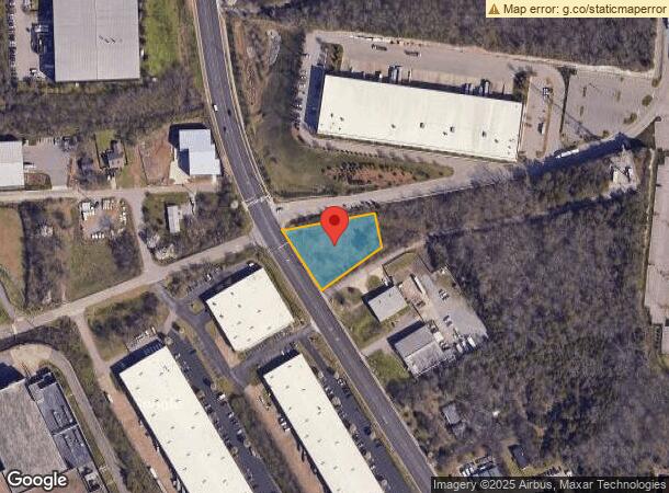
2715 Brick Church Pike, Nashville, TN 37207

NEARBY LISTINGS FOR SALE OR LEASE
Property Detail
2715 Brick Church Pike
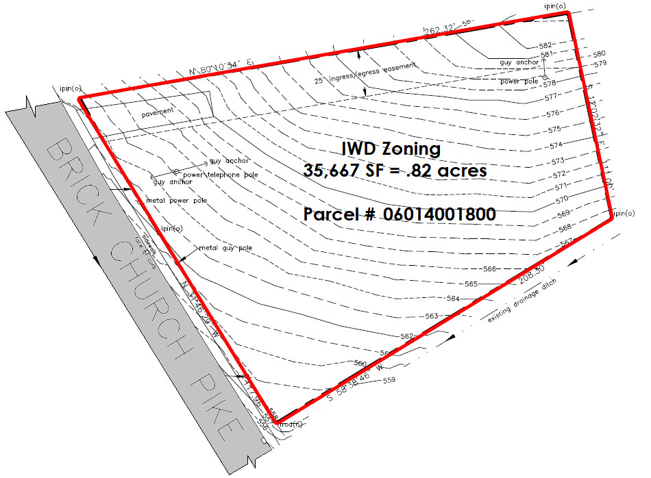
060-14-0-018
E SIDE BRICK CHURCH PIKE AND, N OF OLD TRINITY LANE
Industrialacreage
Davidson
X
Tennessee
47037C0234H
0.88 AC
2024
West
2024
Nashville
012701
Nashville-Davidson--Murfreesboro--Franklin, TN
DEMOGRAPHICS near 2715 Brick Church Pike
1 Mile
3 Mile
5 Mile
2024 Total Population
5,993
74,866
189,732
2029 Population
6,220
76,296
193,633
Pop Growth 2024-2029
+ 3.79%
+ 1.91%
+ 2.06%
Average Age
34
36
37
2024 Total Households
2,203
32,351
85,562
HH Growth 2024-2029
+ 3.63%
+ 2.12%
+ 2.39%
Median Household Inc
$39,901
$58,638
$59,940
Avg Household Size
2.60
2.20
2.10
2024 Avg HH Vehicles
2.00
2.00
2.00
Median Home Value
$355,797
$339,913
$358,120
Median Year Built
1997
1993
1997
Nearby Places
- Restaurants
- Banks
- Shops
- Fitness
- Groceries
PUBLIC TRANSPORTATION
COMMUTER RAIL
Riverfront (East Corridor Line - Tennessee Regional Transportation Authority Music City Star (Music City Star))
DRIVE
WALK
Distance
Riverfront (East Corridor Line - Tennessee Regional Transportation Authority Music City Star (Music City Star))
8 min
4.7 mi
AIRPORT
Nashville International
DRIVE
WALK
Distance
Nashville International
18 min
12.4 mi
Freight Ports
Port of Mobile
DRIVE
WALK
Distance
Port of Mobile
491 min
449.9 mi
SALE & LEASE HISTORY
LISTING DATE
SALE/LEASE

May 19, 2017
For Sale
Aug 02, 2017
For Sale
Apr 14, 2017
For Sale
Nearby Properties
Address
Land Use
TOTAL SIZE
Lot Size
Zoning
Address
Land Use
TOTAL SIZE
Lot Size
Zoning
35,620 SF
8.86 AC
IG
Address
Land Use
TOTAL SIZE
Lot Size
Zoning
43,022 SF
17.02 AC
MULTIZONE
Address
Land Use
TOTAL SIZE
Lot Size
Zoning
25,326 SF
16.89 AC
SP
Address
Land Use
TOTAL SIZE
Lot Size
Zoning
226,184 SF
10.01 AC
IWD
Address
Land Use
TOTAL SIZE
Lot Size
Zoning
267,538 SF
1.78 AC
MULTI-ZONE
Address
Land Use
TOTAL SIZE
Lot Size
Zoning
242,672 SF
16.30 AC
MULTI-ZONE
Address
Land Use
TOTAL SIZE
Lot Size
Zoning
74,132 SF
6.12 AC
SP
Address
Land Use
TOTAL SIZE
Lot Size
Zoning
25,872 SF
13.31 AC
MUL
Address
Land Use
TOTAL SIZE
Lot Size
Zoning
29,064 SF
15.11 AC
MULTIZONE
Address
Land Use
TOTAL SIZE
Lot Size
Zoning
363,125 SF
51.28 AC
MULTI-ZONE
Address
Land Use
TOTAL SIZE
Lot Size
Zoning
440,676 SF
7.33 AC
SP
Address
Land Use
TOTAL SIZE
Lot Size
Zoning
18,700 SF
8.32 AC
MULTI-ZONE
Address
Land Use
TOTAL SIZE
Lot Size
Zoning
34,160 SF
9.20 AC
R10
Address
Land Use
TOTAL SIZE
Lot Size
Zoning
56,175 SF
11.40 AC
MULTIZONE
Address
Land Use
TOTAL SIZE
Lot Size
Zoning
178,790 SF
4.74 AC
SP
Address
Land Use
TOTAL SIZE
Lot Size
Zoning
327,884 SF
2.93 AC
SP
Address
Land Use
TOTAL SIZE
Lot Size
Zoning
295,670 SF
2.17 AC
MULTI-ZONE
Address
Land Use
TOTAL SIZE
Lot Size
Zoning
55,073 SF
11.42 AC
IWD
Address
Land Use
TOTAL SIZE
Lot Size
Zoning
342,416 SF
3.16 AC
MULTIZONE
Address
Land Use
TOTAL SIZE
Lot Size
Zoning
100,400 SF
7.94 AC
MULTIZONE
Address
Land Use
TOTAL SIZE
Lot Size
Zoning
270,245 SF
7.39 AC
MUG
Address
Land Use
TOTAL SIZE
Lot Size
Zoning
125,064 SF
1.71 AC
CS
Address
Land Use
TOTAL SIZE
Lot Size
Zoning
73,439 SF
3.68 AC
MULTIZONE
Address
Land Use
TOTAL SIZE
Lot Size
Zoning
319,128 SF
5.18 AC
MULTI-ZONE
Address
Land Use
TOTAL SIZE
Lot Size
Zoning
83,995 SF
16.13 AC
IR
Address
Land Use
TOTAL SIZE
Lot Size
Zoning
66,976 SF
10.87 AC
MUG
Address
Land Use
TOTAL SIZE
Lot Size
Zoning
10,604 SF
17.59 AC
R8
Address
Land Use
TOTAL SIZE
Lot Size
Zoning
14,024 SF
MULTIZONE
Address
Land Use
TOTAL SIZE
Lot Size
Zoning
69,621 SF
2.52 AC
MUL
Address
Land Use
TOTAL SIZE
Lot Size
Zoning
264,136 SF
3.47 AC
MULTIZONE
The World's #1 Commercial Real Estate Marketplace
Connect with us
© 2025 CoStar Group
The information above has been obtained from sources believed reliable. While we do not doubt its accuracy we have not verified it and make no guarantee, warranty or representation about it. It is your responsibility to independently confirm its accuracy and completeness. Any projections, opinions, assumptions, or estimates used are for example only and do not represent the current or future performance of the property. The value of this transaction to you depends on tax and other factors which should be evaluated by your tax, financial, and legal advisors. You and your advisors should conduct a careful, independent investigation of the property to determine to your satisfaction the suitability of the property for your needs.