Property Record
Charlotte Hwy, Lancaster, SC 29720
NEARBY LISTINGS FOR SALE OR LEASE
Property Detail
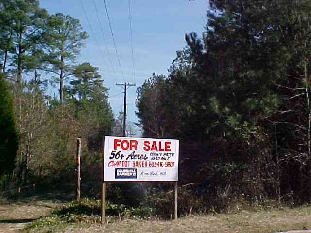
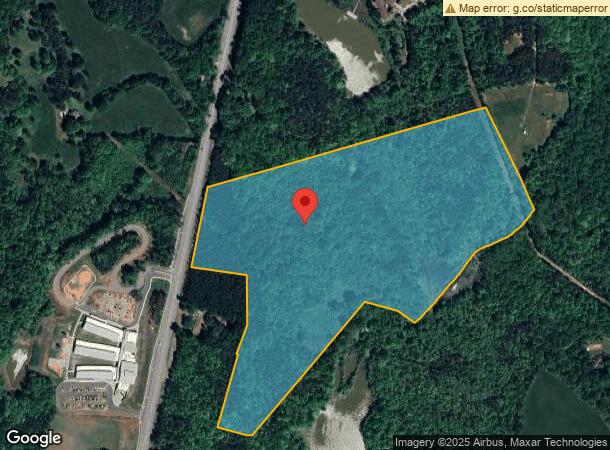
Charlotte Hwy
0026-00-057.00
Plat Of Survey For William R Cresthaw
Taxexempt
Lancaster
X
South Carolina
45023C0150C
53.90 AC
2023
Lancaster County
2023
Charlotte
011002
Charlotte-Concord-Gastonia, NC-SC
DEMOGRAPHICS near Charlotte Hwy
1 Mile
3 Mile
5 Mile
2024 Total Population
250
2,838
15,285
2029 Population
302
3,367
18,190
Pop Growth 2024-2029
+ 20.80%
+ 18.64%
+ 19.01%
Average Age
44
44
46
2024 Total Households
94
1,076
6,007
HH Growth 2024-2029
+ 21.28%
+ 18.77%
+ 19.09%
Median Household Inc
$75,833
$68,790
$84,153
Avg Household Size
2.70
2.60
2.50
2024 Avg HH Vehicles
3.00
2.00
2.00
Median Home Value
$325,000
$328,448
$361,739
Median Year Built
1995
1996
2008
Nearby Places
- Restaurants
- Banks
- Shops
- Fitness
- Groceries
PUBLIC TRANSPORTATION
AIRPORT
Charlotte/Douglas International
DRIVE
WALK
Distance
Charlotte/Douglas International
46 min
29.4 mi
Freight Ports
North Charleston Terminal
DRIVE
WALK
Distance
North Charleston Terminal
206 min
175.0 mi
SALE & LEASE HISTORY
LISTING DATE
SALE/LEASE

Sep 24, 2016
For Sale
Nearby Properties
Address
Land Use
TOTAL SIZE
Lot Size
Zoning
Address
Land Use
TOTAL SIZE
Lot Size
Zoning
108,195 SF
37.07 AC
INS
Address
Land Use
TOTAL SIZE
Lot Size
Zoning
146.15 AC
RN
Address
Land Use
TOTAL SIZE
Lot Size
Zoning
236.44 AC
RA-40 UNIO
Address
Land Use
TOTAL SIZE
Lot Size
Zoning
28,260 SF
5.57 AC
GB
Address
Land Use
TOTAL SIZE
Lot Size
Zoning
3,472 SF
101.18 AC
RN
Address
Land Use
TOTAL SIZE
Lot Size
Zoning
4,424 SF
6.40 AC
INS
Address
Land Use
TOTAL SIZE
Lot Size
Zoning
5.10 AC
RA-40 UNIO
Address
Land Use
TOTAL SIZE
Lot Size
Zoning
5.10 AC
RA-40 UNIO
Address
Land Use
TOTAL SIZE
Lot Size
Zoning
10.24 AC
RA-40 UNIO
Address
Land Use
TOTAL SIZE
Lot Size
Zoning
5.30 AC
RA-40 UNIO
Address
Land Use
TOTAL SIZE
Lot Size
Zoning
5 AC
RA-40 UNIO
Address
Land Use
TOTAL SIZE
Lot Size
Zoning
5.66 AC
RA-40 UNIO
Address
Land Use
TOTAL SIZE
Lot Size
Zoning
1.41 AC
RA-40 UNIO
Address
Land Use
TOTAL SIZE
Lot Size
Zoning
5.06 AC
RA-40 UNIO
Address
Land Use
TOTAL SIZE
Lot Size
Zoning
5.40 AC
RA-40 UNIO
Address
Land Use
TOTAL SIZE
Lot Size
Zoning
5.46 AC
RA-40 UNIO
Address
Land Use
TOTAL SIZE
Lot Size
Zoning
0.20 AC
INS
Address
Land Use
TOTAL SIZE
Lot Size
Zoning
13,600 SF
5.02 AC
INS
Address
Land Use
TOTAL SIZE
Lot Size
Zoning
2.44 AC
RA-40 UNIO
Address
Land Use
TOTAL SIZE
Lot Size
Zoning
5.66 AC
RA-40 UNIO
Address
Land Use
TOTAL SIZE
Lot Size
Zoning
3,112 SF
6.84 AC
RN
Address
Land Use
TOTAL SIZE
Lot Size
Zoning
6.63 AC
RA-40 UNIO
Address
Land Use
TOTAL SIZE
Lot Size
Zoning
43 AC
RA-40 UNIO
Address
Land Use
TOTAL SIZE
Lot Size
Zoning
5.26 AC
RA-40 UNIO
Address
Land Use
TOTAL SIZE
Lot Size
Zoning
13.13 AC
LI
Address
Land Use
TOTAL SIZE
Lot Size
Zoning
6,296 SF
4 AC
INS
Address
Land Use
TOTAL SIZE
Lot Size
Zoning
1.02 AC
RA-40 UNIO
Address
Land Use
TOTAL SIZE
Lot Size
Zoning
0.94 AC
RA-40 UNIO
Address
Land Use
TOTAL SIZE
Lot Size
Zoning
4,745 SF
5 AC
RA-40 UNIO
The World's #1 Commercial Real Estate Marketplace
Connect with us
© 2025 CoStar Group
The information above has been obtained from sources believed reliable. While we do not doubt its accuracy we have not verified it and make no guarantee, warranty or representation about it. It is your responsibility to independently confirm its accuracy and completeness. Any projections, opinions, assumptions, or estimates used are for example only and do not represent the current or future performance of the property. The value of this transaction to you depends on tax and other factors which should be evaluated by your tax, financial, and legal advisors. You and your advisors should conduct a careful, independent investigation of the property to determine to your satisfaction the suitability of the property for your needs.