Property Record
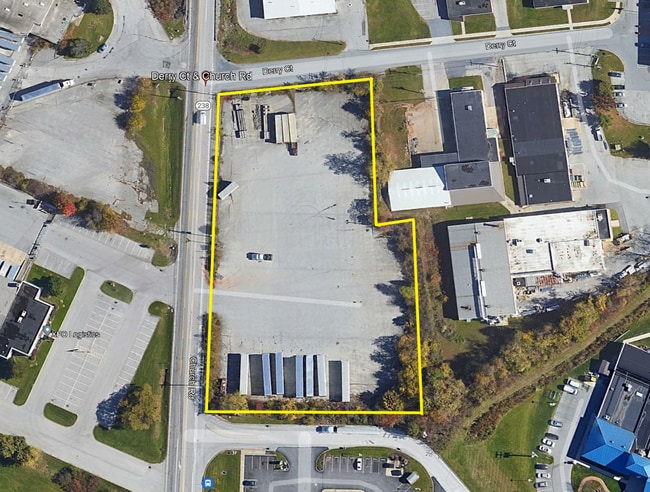
Church Rd At Derry Ct, York, PA 17406

NEARBY LISTINGS FOR SALE OR LEASE
Property Detail
Church Rd At Derry Ct
36-000-LH-0001.B0-00000
York
Industrialgeneral
Pennsylvania
X
2.72 AC
42133C0213F
York County
2025
Philadelphia
2025
York-Hanover, PA
010132
DEMOGRAPHICS near Church Rd At Derry Ct
1 Mile
3 Mile
5 Mile
2024 Total Population
2,326
31,695
127,497
2029 Population
2,358
32,522
130,812
Pop Growth 2024-2029
+ 1.38%
+ 2.61%
+ 2.60%
Average Age
38
41
39
2024 Total Households
815
12,106
49,592
HH Growth 2024-2029
+ 1.35%
+ 2.64%
+ 2.63%
Median Household Inc
$108,166
$86,292
$61,588
Avg Household Size
2.80
2.50
2.50
2024 Avg HH Vehicles
2.00
2.00
2.00
Median Home Value
$211,403
$205,128
$170,658
Median Year Built
1993
1989
1962
Nearby Places
Map Layers
Map Styles
 Street
 Aerial
- Restaurants
- Banks
- Shops
- Fitness
- Groceries
PUBLIC TRANSPORTATION
AIRPORT
Harrisburg International
DRIVE
WALK
Distance
Harrisburg International
35 min
25.8 mi
Freight Ports
Port of Baltimore
DRIVE
WALK
Distance
Port of Baltimore
84 min
61.0 mi
SALE & LEASE HISTORY
LISTING DATE
SALE/LEASE

Jun 29, 2022
For Sale
Nearby Properties
Address
Land Use
TOTAL SIZE
Lot Size
Zoning
Address
Land Use
TOTAL SIZE
Lot Size
Zoning
93.42 AC
Address
Land Use
TOTAL SIZE
Lot Size
Zoning
1,456 SF
97.78 AC
AG
Address
Land Use
TOTAL SIZE
Lot Size
Zoning
21 AC
I
Address
Land Use
TOTAL SIZE
Lot Size
Zoning
89.58 AC
ID
Address
Land Use
TOTAL SIZE
Lot Size
Zoning
603,000 SF
56.64 AC
AG
Address
Land Use
TOTAL SIZE
Lot Size
Zoning
754,640 SF
54.36 AC
Address
Land Use
TOTAL SIZE
Lot Size
Zoning
708,000 SF
55.49 AC
I
Address
Land Use
TOTAL SIZE
Lot Size
Zoning
624,000 SF
50.30 AC
AG
Address
Land Use
TOTAL SIZE
Lot Size
Zoning
378,090 SF
38.70 AC
I
Address
Land Use
TOTAL SIZE
Lot Size
Zoning
174,841 SF
27.30 AC
RS
Address
Land Use
TOTAL SIZE
Lot Size
Zoning
496,062 SF
45.60 AC
I
Address
Land Use
TOTAL SIZE
Lot Size
Zoning
390,000 SF
32.13 AC
RS
Address
Land Use
TOTAL SIZE
Lot Size
Zoning
390,619 SF
46.36 AC
I
Address
Land Use
TOTAL SIZE
Lot Size
Zoning
28.77 AC
I
Address
Land Use
TOTAL SIZE
Lot Size
Zoning
23.72 AC
AG
Address
Land Use
TOTAL SIZE
Lot Size
Zoning
193,025 SF
32.22 AC
I
Address
Land Use
TOTAL SIZE
Lot Size
Zoning
265,645 SF
18.19 AC
I
Address
Land Use
TOTAL SIZE
Lot Size
Zoning
12.12 AC
Address
Land Use
TOTAL SIZE
Lot Size
Zoning
14.22 AC
Address
Land Use
TOTAL SIZE
Lot Size
Zoning
9,000 SF
15.45 AC
V
Address
Land Use
TOTAL SIZE
Lot Size
Zoning
40.04 AC
AG
Address
Land Use
TOTAL SIZE
Lot Size
Zoning
483,676 SF
165.85 AC
I
Address
Land Use
TOTAL SIZE
Lot Size
Zoning
11.22 AC
Address
Land Use
TOTAL SIZE
Lot Size
Zoning
340,000 SF
24.63 AC
I
Address
Land Use
TOTAL SIZE
Lot Size
Zoning
15.88 AC
AG
Address
Land Use
TOTAL SIZE
Lot Size
Zoning
15.55 AC
I
Address
Land Use
TOTAL SIZE
Lot Size
Zoning
6.44 AC
RS
Address
Land Use
TOTAL SIZE
Lot Size
Zoning
248,040 SF
21.39 AC
I
Address
Land Use
TOTAL SIZE
Lot Size
Zoning
43,200 SF
19 AC
RH
Address
Land Use
TOTAL SIZE
Lot Size
Zoning
55,276 SF
40.39 AC
I
The World's #1 Commercial Real Estate Marketplace
Connect with us
© 2025 CoStar Group
The information above has been obtained from sources believed reliable. While we do not doubt its accuracy we have not verified it and make no guarantee, warranty or representation about it. It is your responsibility to independently confirm its accuracy and completeness. Any projections, opinions, assumptions, or estimates used are for example only and do not represent the current or future performance of the property. The value of this transaction to you depends on tax and other factors which should be evaluated by your tax, financial, and legal advisors. You and your advisors should conduct a careful, independent investigation of the property to determine to your satisfaction the suitability of the property for your needs.