Property Record
Dix-Toledo Rd, Brownstown, MI 48183
This Property Is For Sale
NEARBY LISTINGS FOR SALE OR LEASE
Property Detail
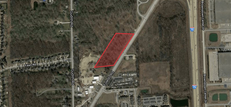
Dix-Toledo Rd
Detroit-Warren-Dearborn, MI
09E1B2 T4S PART OF SE 1/4 OF SEC 9 T4SR10E BEG S33DEG 36M W 196FT FROM INT OF THE E LINE OF SEC 9 AND THE NW LINE OF TOLEDO HWY TH S33DEG 36M W 764.74FT TH S87DEG 14M 30S W 350FT TH N33DEG 36M E 764.74FT TH N87DEG 14M 30S E 350FT POB 4.95 AC
70-030-99-0003-000
Wayne
Commercialacreage
Michigan
X
0003
26163C0411E
4.95 AC
2024
Downriver South
2024
Detroit
594300
DEMOGRAPHICS near Dix-Toledo Rd
1 Mile
3 Mile
5 Mile
2024 Total Population
5,256
49,292
141,177
2029 Population
5,078
47,369
135,447
Pop Growth 2024-2029
(3.39%)
(3.90%)
(4.06%)
Average Age
40
42
42
2024 Total Households
2,154
20,350
58,854
HH Growth 2024-2029
(3.30%)
(3.92%)
(4.09%)
Median Household Inc
$65,110
$71,273
$67,845
Avg Household Size
2.40
2.40
2.30
2024 Avg HH Vehicles
2.00
2.00
2.00
Median Home Value
$210,820
$200,540
$180,750
Median Year Built
1990
1975
1972
Nearby Places
- Restaurants
- Banks
- Shops
- Fitness
- Groceries
PUBLIC TRANSPORTATION
AIRPORT
Detroit Metro Wayne County
Drive
Walk
Distance
Detroit Metro Wayne County
21 min
13.4 mi
Windsor International
Drive
Walk
Distance
Windsor International
46 min
28.9 mi
Freight Ports
Port of Toledo
Drive
Walk
Distance
Port of Toledo
56 min
43.5 mi
Nearby Properties
Address
Land Use
TOTAL SIZE
Lot Size
Zoning
Address
Land Use
TOTAL SIZE
Lot Size
Zoning
262675
228.88 AC
Address
Land Use
TOTAL SIZE
Lot Size
Zoning
137.23 AC
I-3
Address
Land Use
TOTAL SIZE
Lot Size
Zoning
20191
166.35 AC
I-2
Address
Land Use
TOTAL SIZE
Lot Size
Zoning
182.23 AC
Address
Land Use
TOTAL SIZE
Lot Size
Zoning
155600
83.84 AC
R1
Address
Land Use
TOTAL SIZE
Lot Size
Zoning
234443
23.47 AC
Address
Land Use
TOTAL SIZE
Lot Size
Zoning
11.88 AC
PUD
Address
Land Use
TOTAL SIZE
Lot Size
Zoning
150224
15.45 AC
RM-1
Address
Land Use
TOTAL SIZE
Lot Size
Zoning
729040
45.85 AC
I-2
Address
Land Use
TOTAL SIZE
Lot Size
Zoning
218586
21.39 AC
I-1
Address
Land Use
TOTAL SIZE
Lot Size
Zoning
35.50 AC
RM-1
Address
Land Use
TOTAL SIZE
Lot Size
Zoning
163.58 AC
Address
Land Use
TOTAL SIZE
Lot Size
Zoning
21.10 AC
TC
Address
Land Use
TOTAL SIZE
Lot Size
Zoning
172998
17.91 AC
RM-1
Address
Land Use
TOTAL SIZE
Lot Size
Zoning
122430
22.24 AC
Address
Land Use
TOTAL SIZE
Lot Size
Zoning
203456
21.80 AC
Address
Land Use
TOTAL SIZE
Lot Size
Zoning
42.98 AC
Address
Land Use
TOTAL SIZE
Lot Size
Zoning
178682
19.23 AC
Address
Land Use
TOTAL SIZE
Lot Size
Zoning
203114
14.50 AC
R-M MUL
Address
Land Use
TOTAL SIZE
Lot Size
Zoning
33600
100.03 AC
Address
Land Use
TOTAL SIZE
Lot Size
Zoning
12.63 AC
PUD
Address
Land Use
TOTAL SIZE
Lot Size
Zoning
125828
8.17 AC
B-2 COM
Address
Land Use
TOTAL SIZE
Lot Size
Zoning
2160
334.88 AC
I1
Address
Land Use
TOTAL SIZE
Lot Size
Zoning
3.73 AC
RM-2
Address
Land Use
TOTAL SIZE
Lot Size
Zoning
207456
7.74 AC
I-1
Address
Land Use
TOTAL SIZE
Lot Size
Zoning
61784
6.78 AC
Address
Land Use
TOTAL SIZE
Lot Size
Zoning
68409
64.56 AC
Address
Land Use
TOTAL SIZE
Lot Size
Zoning
59427
5.50 AC
Address
Land Use
TOTAL SIZE
Lot Size
Zoning
141861
13 AC
RM-1
Address
Land Use
TOTAL SIZE
Lot Size
Zoning
167004
19.04 AC
RM-1
Start a new search to find other properties for sale or lease
Connect with us
© 2024 CoStar Group
The information above has been obtained from sources believed reliable. While we do not doubt its accuracy we have not verified it and make no guarantee, warranty or representation about it. It is your responsibility to independently confirm its accuracy and completeness. Any projections, opinions, assumptions, or estimates used are for example only and do not represent the current or future performance of the property. The value of this transaction to you depends on tax and other factors which should be evaluated by your tax, financial, and legal advisors. You and your advisors should conduct a careful, independent investigation of the property to determine to your satisfaction the suitability of the property for your needs.