Property Record
Fm 78, San Antonio, TX 78244
NEARBY LISTINGS FOR SALE OR LEASE
Property Detail
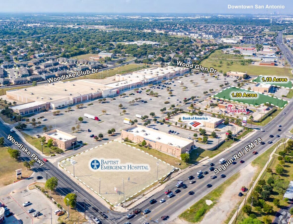
Fm 78
San Antonio-New Braunfels, TX
Woodlake Sub
05080-229-0050
CB 5080B BLK 29 LOT 5 FM 78 @ WOODLAKE SUBD NEW ACCT FOR 2008 - PLAT 9575/208-210 FILED 6/15/2007
Vacantlandnec
Bexar
X
Texas
48029C0430G
5
2024
1.39 AC
2023
Northeast
131615
San Antonio
DEMOGRAPHICS near Fm 78
1 Mile
3 Mile
5 Mile
2024 Total Population
15,432
115,483
208,332
2029 Population
16,734
123,440
222,164
Pop Growth 2024-2029
+ 8.44%
+ 6.89%
+ 6.64%
Average Age
35
36
36
2024 Total Households
5,169
38,442
72,448
HH Growth 2024-2029
+ 8.57%
+ 6.99%
+ 6.72%
Median Household Inc
$63,669
$62,070
$60,654
Avg Household Size
2.90
2.90
2.80
2024 Avg HH Vehicles
2.00
2.00
2.00
Median Home Value
$171,868
$171,988
$178,702
Median Year Built
2003
1995
1989
Nearby Places
- Restaurants
- Banks
- Shops
- Fitness
- Groceries
PUBLIC TRANSPORTATION
AIRPORT
San Antonio International
DRIVE
WALK
Distance
San Antonio International
19 min
9.9 mi
Freight Ports
Calhoun Port
DRIVE
WALK
Distance
Calhoun Port
176 min
143.4 mi
SALE & LEASE HISTORY
LISTING DATE
SALE/LEASE

Sep 24, 2016
For Sale
Sep 01, 2017
For Lease
Sep 01, 2017
For Sale
Jul 27, 2017
For Lease
Nearby Properties
Address
Land Use
TOTAL SIZE
Lot Size
Zoning
Address
Land Use
TOTAL SIZE
Lot Size
Zoning
727,299 SF
47.68 AC
Address
Land Use
TOTAL SIZE
Lot Size
Zoning
1,648,588 SF
70 AC
Address
Land Use
TOTAL SIZE
Lot Size
Zoning
278,406 SF
13.39 AC
Address
Land Use
TOTAL SIZE
Lot Size
Zoning
435,592 SF
31.43 AC
Address
Land Use
TOTAL SIZE
Lot Size
Zoning
598,070 SF
46.05 AC
Address
Land Use
TOTAL SIZE
Lot Size
Zoning
249,633 SF
7.04 AC
Address
Land Use
TOTAL SIZE
Lot Size
Zoning
230,659 SF
15.48 AC
Address
Land Use
TOTAL SIZE
Lot Size
Zoning
337,468 SF
21.84 AC
Address
Land Use
TOTAL SIZE
Lot Size
Zoning
252,465 SF
37.40 AC
Address
Land Use
TOTAL SIZE
Lot Size
Zoning
273,516 SF
17.50 AC
Address
Land Use
TOTAL SIZE
Lot Size
Zoning
325,434 SF
21.47 AC
Address
Land Use
TOTAL SIZE
Lot Size
Zoning
431,326 SF
42.70 AC
Address
Land Use
TOTAL SIZE
Lot Size
Zoning
258,063 SF
24.55 AC
Address
Land Use
TOTAL SIZE
Lot Size
Zoning
251,680 SF
15.52 AC
Address
Land Use
TOTAL SIZE
Lot Size
Zoning
2,457 SF
60.19 AC
Address
Land Use
TOTAL SIZE
Lot Size
Zoning
239,856 SF
12.40 AC
Address
Land Use
TOTAL SIZE
Lot Size
Zoning
437,807 SF
24.55 AC
Address
Land Use
TOTAL SIZE
Lot Size
Zoning
391,863 SF
24.43 AC
Address
Land Use
TOTAL SIZE
Lot Size
Zoning
144,814 SF
8.18 AC
Address
Land Use
TOTAL SIZE
Lot Size
Zoning
200,595 SF
16.27 AC
Address
Land Use
TOTAL SIZE
Lot Size
Zoning
176,907 SF
12.73 AC
Address
Land Use
TOTAL SIZE
Lot Size
Zoning
34.40 AC
Address
Land Use
TOTAL SIZE
Lot Size
Zoning
148,639 SF
14.88 AC
Address
Land Use
TOTAL SIZE
Lot Size
Zoning
125,882 SF
5.68 AC
Address
Land Use
TOTAL SIZE
Lot Size
Zoning
467,359 SF
34.88 AC
Address
Land Use
TOTAL SIZE
Lot Size
Zoning
291,300 SF
17.90 AC
Address
Land Use
TOTAL SIZE
Lot Size
Zoning
16,483 SF
61.92 AC
Address
Land Use
TOTAL SIZE
Lot Size
Zoning
83,178 SF
22.50 AC
Address
Land Use
TOTAL SIZE
Lot Size
Zoning
192,677 SF
16.14 AC
Address
Land Use
TOTAL SIZE
Lot Size
Zoning
361,780 SF
19.99 AC
The World's #1 Commercial Real Estate Marketplace
Connect with us
© 2025 CoStar Group
The information above has been obtained from sources believed reliable. While we do not doubt its accuracy we have not verified it and make no guarantee, warranty or representation about it. It is your responsibility to independently confirm its accuracy and completeness. Any projections, opinions, assumptions, or estimates used are for example only and do not represent the current or future performance of the property. The value of this transaction to you depends on tax and other factors which should be evaluated by your tax, financial, and legal advisors. You and your advisors should conduct a careful, independent investigation of the property to determine to your satisfaction the suitability of the property for your needs.