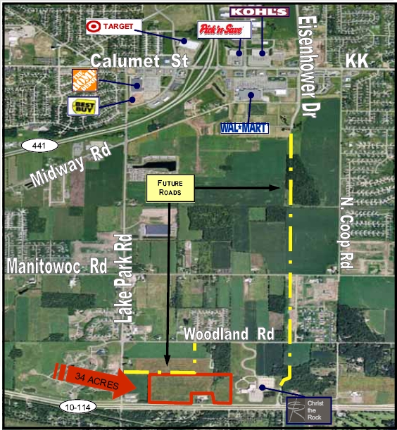
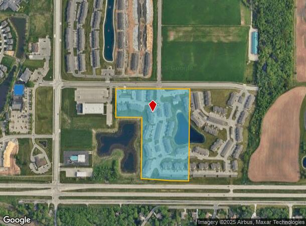
Property Record
Highway 10 & 114, Menasha, WI 54952
NEARBY LISTINGS FOR SALE OR LEASE
Property Detail
Highway 10 & 114
Appleton, WI
Certified Surv Map #2258
33654
149-79,J1944-10,J4962-1 SE1/4 NW1/4 SEC 16-20-18 PRT OF LOT 2 CSM#2258 V.16-305 COM659E & 258.5N W1/4/C, N1058.01,E826.75,S1065.7, W203.15,W300.73,W200, W124.52TO POB EX ROW LYG N OF PCL DOC#493024 EX DOC#494992(4.62A)
Commercialnec
Calumet
X
Wisconsin
55087C0455D
2
2024
14.62 AC
2024
Calumet County
002602
Green Bay
379,001 SF
DEMOGRAPHICS near Highway 10 & 114
1 Mile
3 Mile
5 Mile
2024 Total Population
3,540
32,000
108,132
2029 Population
3,546
32,589
110,513
Pop Growth 2024-2029
+ 0.17%
+ 1.84%
+ 2.20%
Average Age
38
39
39
2024 Total Households
1,333
12,310
43,843
HH Growth 2024-2029
0.00%
+ 1.85%
+ 2.21%
Median Household Inc
$104,731
$86,849
$69,880
Avg Household Size
2.70
2.60
2.40
2024 Avg HH Vehicles
2.00
2.00
2.00
Median Home Value
$336,929
$227,339
$193,955
Median Year Built
2005
1992
1976
Nearby Places
- Restaurants
- Banks
- Shops
- Fitness
- Groceries
PUBLIC TRANSPORTATION
AIRPORT
Appleton International
DRIVE
WALK
Distance
Appleton International
21 min
12.7 mi
Green Bay/Austin Straubel International
DRIVE
WALK
Distance
Green Bay/Austin Straubel International
40 min
28.9 mi
Freight Ports
Port Milwaukee
DRIVE
WALK
Distance
Port Milwaukee
129 min
108.3 mi
Nearby Properties
Address
Land Use
TOTAL SIZE
Lot Size
Zoning
Address
Land Use
TOTAL SIZE
Lot Size
Zoning
211,780 SF
23.01 AC
PDR3
Address
Land Use
TOTAL SIZE
Lot Size
Zoning
309,785 SF
20.13 AC
R3
Address
Land Use
TOTAL SIZE
Lot Size
Zoning
5.78 AC
C1
Address
Land Use
TOTAL SIZE
Lot Size
Zoning
249,600 SF
11.88 AC
M1
Address
Land Use
TOTAL SIZE
Lot Size
Zoning
100,105 SF
12.62 AC
C2
Address
Land Use
TOTAL SIZE
Lot Size
Zoning
17.51 AC
Address
Land Use
TOTAL SIZE
Lot Size
Zoning
218,400 SF
12.39 AC
M1
Address
Land Use
TOTAL SIZE
Lot Size
Zoning
232,800 SF
16.62 AC
Address
Land Use
TOTAL SIZE
Lot Size
Zoning
247,520 SF
13.68 AC
M1
Address
Land Use
TOTAL SIZE
Lot Size
Zoning
37,430 SF
7.32 AC
M1
Address
Land Use
TOTAL SIZE
Lot Size
Zoning
12.49 AC
Address
Land Use
TOTAL SIZE
Lot Size
Zoning
101,466 SF
13.87 AC
Address
Land Use
TOTAL SIZE
Lot Size
Zoning
200,880 SF
14.60 AC
M1
Address
Land Use
TOTAL SIZE
Lot Size
Zoning
209,059 SF
18.40 AC
PDC2
Address
Land Use
TOTAL SIZE
Lot Size
Zoning
108,328 SF
8.93 AC
R3
Address
Land Use
TOTAL SIZE
Lot Size
Zoning
92,296 SF
13.32 AC
R1
Address
Land Use
TOTAL SIZE
Lot Size
Zoning
78,268 SF
7.80 AC
C3
Address
Land Use
TOTAL SIZE
Lot Size
Zoning
97,867 SF
14.72 AC
R3
Address
Land Use
TOTAL SIZE
Lot Size
Zoning
75,352 SF
9.66 AC
PDC2
Address
Land Use
TOTAL SIZE
Lot Size
Zoning
16,486 SF
10.06 AC
PDR3
Address
Land Use
TOTAL SIZE
Lot Size
Zoning
31,229 SF
24.58 AC
Address
Land Use
TOTAL SIZE
Lot Size
Zoning
32.61 AC
Address
Land Use
TOTAL SIZE
Lot Size
Zoning
3.08 AC
Address
Land Use
TOTAL SIZE
Lot Size
Zoning
66,760 SF
52.60 AC
Address
Land Use
TOTAL SIZE
Lot Size
Zoning
13.23 AC
Address
Land Use
TOTAL SIZE
Lot Size
Zoning
8.08 AC
Address
Land Use
TOTAL SIZE
Lot Size
Zoning
Address
Land Use
TOTAL SIZE
Lot Size
Zoning
8.95 AC
R1A
Address
Land Use
TOTAL SIZE
Lot Size
Zoning
118,250 SF
14.87 AC
PDC2
The World's #1 Commercial Real Estate Marketplace
Connect with us
© 2025 CoStar Group
The information above has been obtained from sources believed reliable. While we do not doubt its accuracy we have not verified it and make no guarantee, warranty or representation about it. It is your responsibility to independently confirm its accuracy and completeness. Any projections, opinions, assumptions, or estimates used are for example only and do not represent the current or future performance of the property. The value of this transaction to you depends on tax and other factors which should be evaluated by your tax, financial, and legal advisors. You and your advisors should conduct a careful, independent investigation of the property to determine to your satisfaction the suitability of the property for your needs.