Property Record
Highway 300, Little Rock, AR 72223
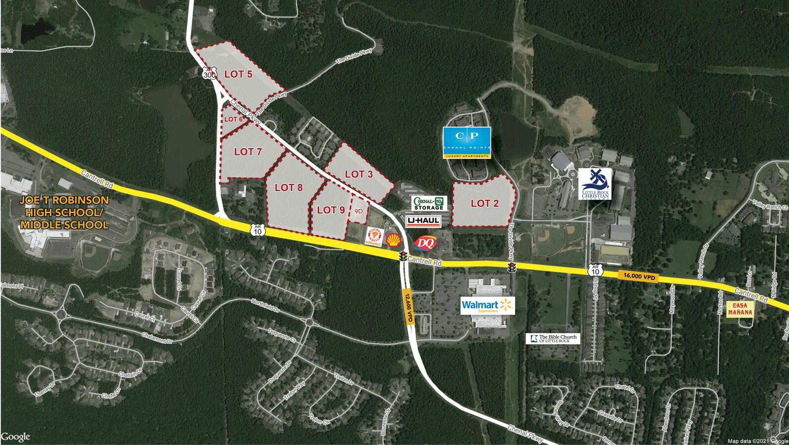
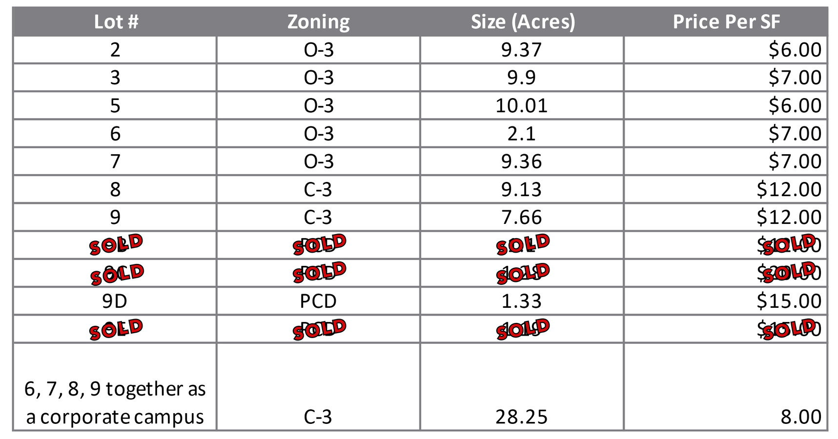
This Property Is For Sale
Land SALE
$640,244 - $21,221,156
1.33 - 10.01 AC Lot
NEARBY LISTINGS FOR SALE OR LEASE
Property Detail
Highway 300
Little Rock-North Little Rock-Conway, AR
West Territory Add
53L-015-00-008-00
PT N1/2 OF SEC 15 MPDA BEG INTERS N R/W LN HWY 10 & WLN SW NE N80*58 W AL SD R/W 91. 9 N80*44W238.54 N0* 3245W668.88 N80*44W1697.30 N0* 2640W1509.27 TO NLN NW NW S89*35 25E AL NLN 677.93 TO NE COR S0*34 8W AL ELN 967.10 S50*4548 E513.83
Residentialacreage
Pulaski
X
Arkansas
05119C0305G
1,2
2023
6.91 AC
2023
West
004213
Little Rock/N Little Rock
DEMOGRAPHICS near Highway 300
1 Mile
3 Mile
5 Mile
2024 Total Population
3,222
14,219
43,095
2029 Population
3,219
14,266
42,938
Pop Growth 2024-2029
(0.09%)
+ 0.33%
(0.36%)
Average Age
40
42
42
2024 Total Households
1,451
5,729
17,630
HH Growth 2024-2029
(0.28%)
+ 0.23%
(0.41%)
Median Household Inc
$97,082
$137,833
$113,645
Avg Household Size
2.20
2.40
2.40
2024 Avg HH Vehicles
2.00
2.00
2.00
Median Home Value
$356,194
$391,875
$348,657
Median Year Built
2005
2004
1997
Nearby Places
- Restaurants
- Banks
- Shops
- Fitness
- Groceries
PUBLIC TRANSPORTATION
AIRPORT
Bill and Hillary Clinton Ntl/Adams Field
DRIVE
WALK
Distance
Bill and Hillary Clinton Ntl/Adams Field
30 min
20.2 mi
Freight Ports
Port of Shreveport
DRIVE
WALK
Distance
Port of Shreveport
257 min
237.6 mi
Nearby Properties
Address
Land Use
TOTAL SIZE
Lot Size
Zoning
Address
Land Use
TOTAL SIZE
Lot Size
Zoning
361,360 SF
20.01 AC
Address
Land Use
TOTAL SIZE
Lot Size
Zoning
239,012 SF
52.19 AC
Address
Land Use
TOTAL SIZE
Lot Size
Zoning
82,176 SF
14.83 AC
Address
Land Use
TOTAL SIZE
Lot Size
Zoning
58,828 SF
15.22 AC
Address
Land Use
TOTAL SIZE
Lot Size
Zoning
115,062 SF
10.04 AC
Address
Land Use
TOTAL SIZE
Lot Size
Zoning
160,068 SF
18.91 AC
Address
Land Use
TOTAL SIZE
Lot Size
Zoning
103,169 SF
8.32 AC
Address
Land Use
TOTAL SIZE
Lot Size
Zoning
102,990 SF
10.43 AC
Address
Land Use
TOTAL SIZE
Lot Size
Zoning
42,686 SF
22.11 AC
Address
Land Use
TOTAL SIZE
Lot Size
Zoning
206,671 SF
26.16 AC
Address
Land Use
TOTAL SIZE
Lot Size
Zoning
91,822 SF
14 AC
Address
Land Use
TOTAL SIZE
Lot Size
Zoning
173,120 SF
67.23 AC
Address
Land Use
TOTAL SIZE
Lot Size
Zoning
64,267 SF
22.09 AC
Address
Land Use
TOTAL SIZE
Lot Size
Zoning
99,581 SF
7.89 AC
Address
Land Use
TOTAL SIZE
Lot Size
Zoning
66,072 SF
8.53 AC
Address
Land Use
TOTAL SIZE
Lot Size
Zoning
58,854 SF
7.11 AC
Address
Land Use
TOTAL SIZE
Lot Size
Zoning
151,016 SF
14.47 AC
Address
Land Use
TOTAL SIZE
Lot Size
Zoning
38,617 SF
4.62 AC
Address
Land Use
TOTAL SIZE
Lot Size
Zoning
37,229 SF
4.06 AC
Address
Land Use
TOTAL SIZE
Lot Size
Zoning
21.56 AC
Address
Land Use
TOTAL SIZE
Lot Size
Zoning
24,997 SF
9.78 AC
Address
Land Use
TOTAL SIZE
Lot Size
Zoning
58,825 SF
7.34 AC
Address
Land Use
TOTAL SIZE
Lot Size
Zoning
30,510 SF
18.76 AC
Address
Land Use
TOTAL SIZE
Lot Size
Zoning
56,054 SF
20.93 AC
Address
Land Use
TOTAL SIZE
Lot Size
Zoning
19,200 SF
7.25 AC
Address
Land Use
TOTAL SIZE
Lot Size
Zoning
29,097 SF
98.42 AC
Address
Land Use
TOTAL SIZE
Lot Size
Zoning
6,699 SF
7.53 AC
Address
Land Use
TOTAL SIZE
Lot Size
Zoning
73,873 SF
7.26 AC
Address
Land Use
TOTAL SIZE
Lot Size
Zoning
5,890 SF
2 AC
Address
Land Use
TOTAL SIZE
Lot Size
Zoning
23,348 SF
1.46 AC
The World's #1 Commercial Real Estate Marketplace
Connect with us
© 2025 CoStar Group
The information above has been obtained from sources believed reliable. While we do not doubt its accuracy we have not verified it and make no guarantee, warranty or representation about it. It is your responsibility to independently confirm its accuracy and completeness. Any projections, opinions, assumptions, or estimates used are for example only and do not represent the current or future performance of the property. The value of this transaction to you depends on tax and other factors which should be evaluated by your tax, financial, and legal advisors. You and your advisors should conduct a careful, independent investigation of the property to determine to your satisfaction the suitability of the property for your needs.