Property Record
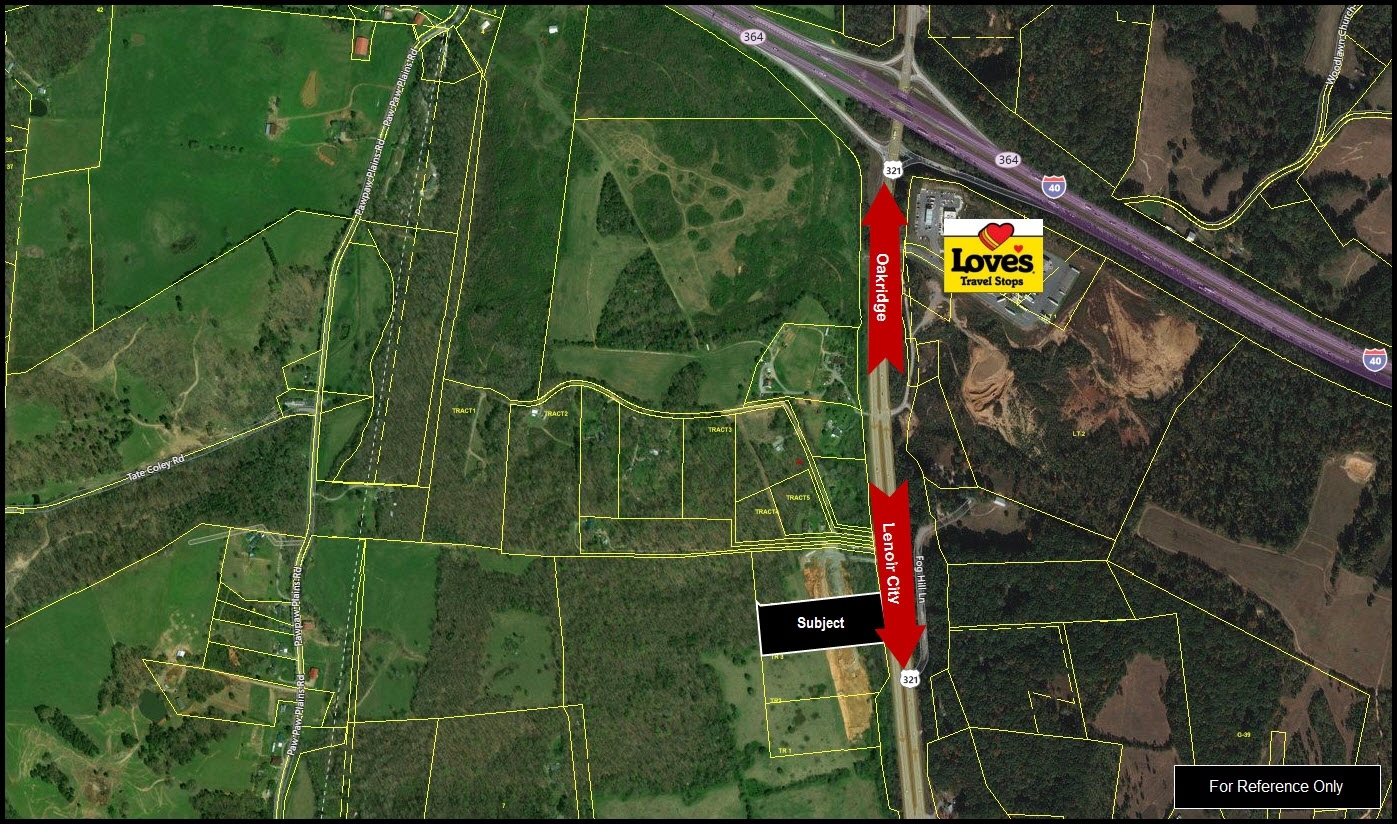
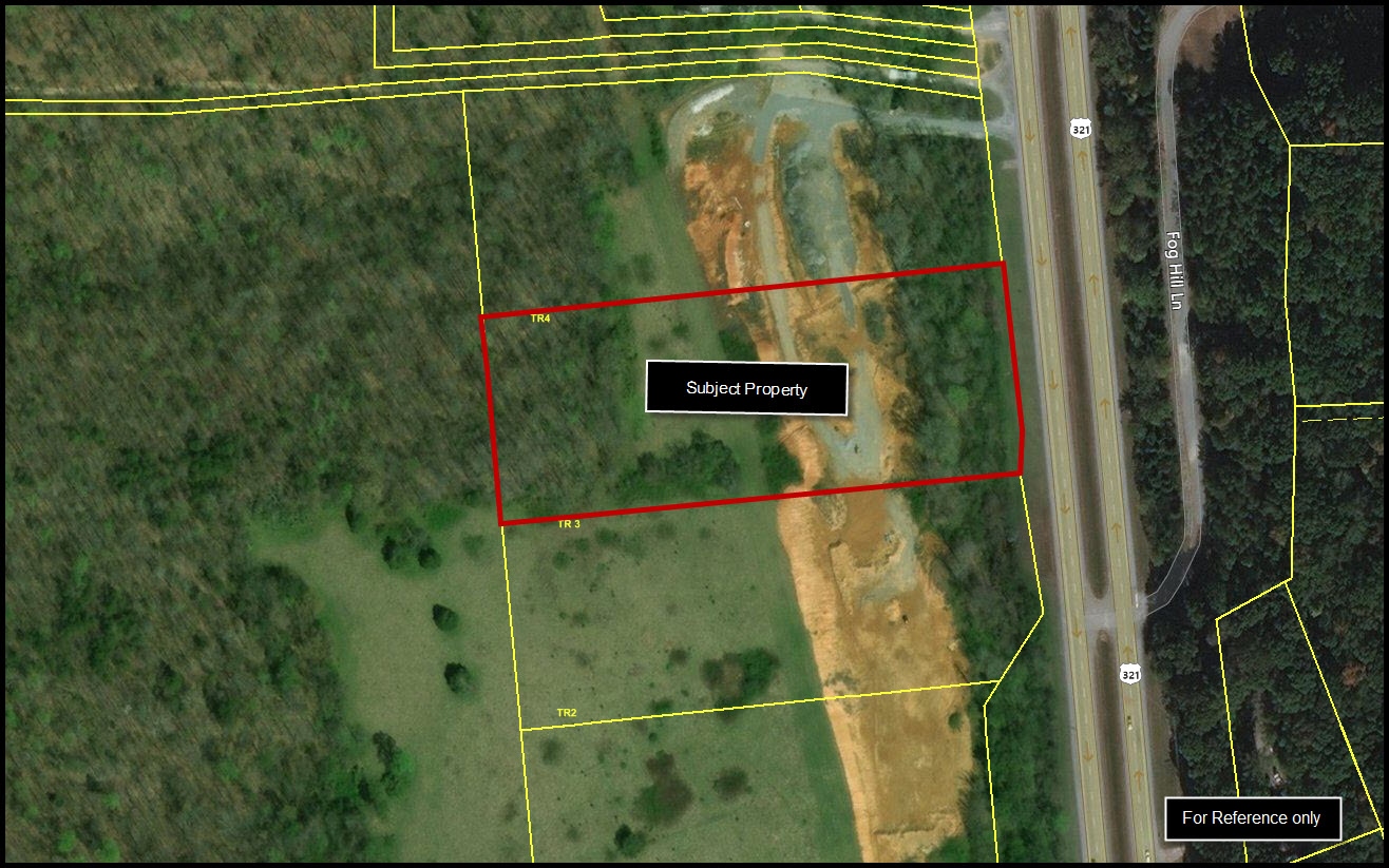
Highway 321 N, Lenoir City, TN 37771
NEARBY LISTINGS FOR SALE OR LEASE
Property Detail
Highway 321 N
005-077.02
DISTRICT: 5
Farms
Loudon
X
Tennessee
47145C0255F
80.03 AC
2023
Loudon County
2024
Knoxville
060204
Knoxville, TN
DEMOGRAPHICS near Highway 321 N
1 Mile
3 Mile
5 Mile
2024 Total Population
388
4,232
15,187
2029 Population
437
4,769
17,265
Pop Growth 2024-2029
+ 12.63%
+ 12.69%
+ 13.68%
Average Age
45
45
43
2024 Total Households
150
1,732
6,215
HH Growth 2024-2029
+ 12.00%
+ 12.30%
+ 13.35%
Median Household Inc
$62,500
$58,086
$63,711
Avg Household Size
2.60
2.40
2.40
2024 Avg HH Vehicles
3.00
2.00
2.00
Median Home Value
$255,479
$247,680
$258,480
Median Year Built
1981
1990
1994
Nearby Places
- Restaurants
- Banks
- Shops
- Fitness
- Groceries
PUBLIC TRANSPORTATION
AIRPORT
McGhee Tyson
DRIVE
WALK
Distance
McGhee Tyson
36 min
26.2 mi
Freight Ports
Georgia Ports - Savannah
DRIVE
WALK
Distance
Georgia Ports - Savannah
491 min
428.6 mi
SALE & LEASE HISTORY
LISTING DATE
SALE/LEASE

Aug 25, 2017
For Sale
Nearby Properties
Address
Land Use
TOTAL SIZE
Lot Size
Zoning
Address
Land Use
TOTAL SIZE
Lot Size
Zoning
207,990 SF
14 AC
C03
Address
Land Use
TOTAL SIZE
Lot Size
Zoning
42,632 SF
23.67 AC
C3
Address
Land Use
TOTAL SIZE
Lot Size
Zoning
180,111 SF
19.83 AC
C3
Address
Land Use
TOTAL SIZE
Lot Size
Zoning
102,156 SF
12.03 AC
C3
Address
Land Use
TOTAL SIZE
Lot Size
Zoning
36,312 SF
0.25 AC
R3
Address
Land Use
TOTAL SIZE
Lot Size
Zoning
1,972 SF
194.59 AC
R1
Address
Land Use
TOTAL SIZE
Lot Size
Zoning
35,705 SF
9.88 AC
R2
Address
Land Use
TOTAL SIZE
Lot Size
Zoning
112,416 SF
12.13 AC
C3
Address
Land Use
TOTAL SIZE
Lot Size
Zoning
55,590 SF
16.13 AC
C3
Address
Land Use
TOTAL SIZE
Lot Size
Zoning
32,380 SF
46.83 AC
C3
Address
Land Use
TOTAL SIZE
Lot Size
Zoning
22,485 SF
0.55 AC
C2
Address
Land Use
TOTAL SIZE
Lot Size
Zoning
45,114 SF
2.06 AC
C4
Address
Land Use
TOTAL SIZE
Lot Size
Zoning
21,992 SF
6.40 AC
R1
Address
Land Use
TOTAL SIZE
Lot Size
Zoning
106,608 SF
11.30 AC
R2
Address
Land Use
TOTAL SIZE
Lot Size
Zoning
13.30 AC
C3
Address
Land Use
TOTAL SIZE
Lot Size
Zoning
25,607 SF
0.51 AC
R3
Address
Land Use
TOTAL SIZE
Lot Size
Zoning
56,948 SF
6.95 AC
R3
Address
Land Use
TOTAL SIZE
Lot Size
Zoning
26,876 SF
2.76 AC
C2
Address
Land Use
TOTAL SIZE
Lot Size
Zoning
32,597 SF
5 AC
O-1
Address
Land Use
TOTAL SIZE
Lot Size
Zoning
20,116 SF
6.60 AC
R1
Address
Land Use
TOTAL SIZE
Lot Size
Zoning
45,188 SF
2.61 AC
C3
Address
Land Use
TOTAL SIZE
Lot Size
Zoning
77,208 SF
2.09 AC
R2
Address
Land Use
TOTAL SIZE
Lot Size
Zoning
41,881 SF
4.12 AC
R1
Address
Land Use
TOTAL SIZE
Lot Size
Zoning
44,430 SF
1.81 AC
C4
Address
Land Use
TOTAL SIZE
Lot Size
Zoning
110,752 SF
14.11 AC
M2
Address
Land Use
TOTAL SIZE
Lot Size
Zoning
26.43 AC
F1
Address
Land Use
TOTAL SIZE
Lot Size
Zoning
19,600 SF
0.16 AC
R2
Address
Land Use
TOTAL SIZE
Lot Size
Zoning
58,124 SF
6 AC
C3
Address
Land Use
TOTAL SIZE
Lot Size
Zoning
21,784 SF
6.63 AC
C3
Address
Land Use
TOTAL SIZE
Lot Size
Zoning
26,556 SF
2.44 AC
R2
The World's #1 Commercial Real Estate Marketplace
Connect with us
© 2025 CoStar Group
The information above has been obtained from sources believed reliable. While we do not doubt its accuracy we have not verified it and make no guarantee, warranty or representation about it. It is your responsibility to independently confirm its accuracy and completeness. Any projections, opinions, assumptions, or estimates used are for example only and do not represent the current or future performance of the property. The value of this transaction to you depends on tax and other factors which should be evaluated by your tax, financial, and legal advisors. You and your advisors should conduct a careful, independent investigation of the property to determine to your satisfaction the suitability of the property for your needs.