Property Record
Highway 92 N, Douglasville, GA 30134
This Property Is For Sale
NEARBY LISTINGS FOR SALE OR LEASE
Property Detail
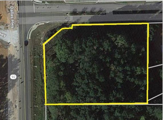
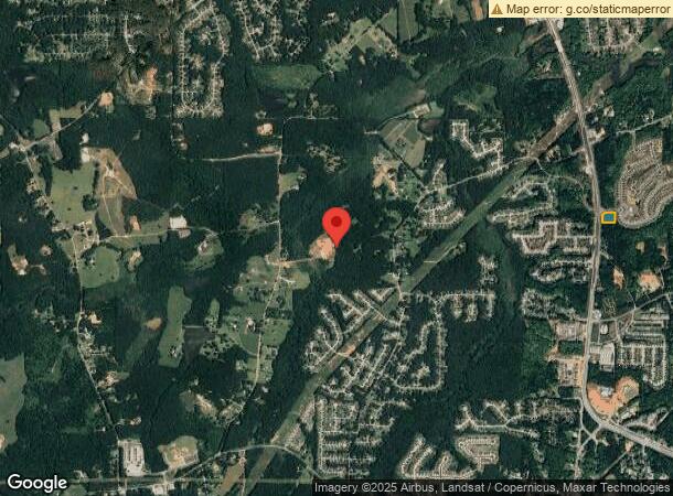
Highway 92 N
8013-06-3-0-014
V/1.63 ACRES +/-, HWY 92 N
Commercialacreage
Douglas
X
Georgia
13097C0063D
1.63 AC
2024
Douglasville/Lithia Springs
2024
Atlanta
080307
Atlanta-Sandy Springs-Roswell, GA
DEMOGRAPHICS near Highway 92 N
1 Mile
3 Mile
5 Mile
2024 Total Population
6,153
35,359
87,602
2029 Population
6,553
38,030
93,977
Pop Growth 2024-2029
+ 6.50%
+ 7.55%
+ 7.28%
Average Age
34
37
38
2024 Total Households
2,029
12,297
30,630
HH Growth 2024-2029
+ 6.60%
+ 7.51%
+ 7.24%
Median Household Inc
$69,645
$61,376
$68,307
Avg Household Size
3.00
2.80
2.80
2024 Avg HH Vehicles
2.00
2.00
2.00
Median Home Value
$182,583
$190,196
$198,823
Median Year Built
2002
1994
1993
Nearby Places
- Restaurants
- Banks
- Shops
- Fitness
- Groceries
PUBLIC TRANSPORTATION
AIRPORT
Hartsfield - Jackson Atlanta International
DRIVE
WALK
Distance
Hartsfield - Jackson Atlanta International
51 min
33.4 mi
Freight Ports
Georgia Ports - Savannah
DRIVE
WALK
Distance
Georgia Ports - Savannah
314 min
272.7 mi
Nearby Properties
Address
Land Use
TOTAL SIZE
Lot Size
Zoning
Address
Land Use
TOTAL SIZE
Lot Size
Zoning
320,483 SF
24.27 AC
DCD
Address
Land Use
TOTAL SIZE
Lot Size
Zoning
522,936 SF
39.33 AC
IL
Address
Land Use
TOTAL SIZE
Lot Size
Zoning
247,203 SF
18.74 AC
DCD
Address
Land Use
TOTAL SIZE
Lot Size
Zoning
449,595 SF
10.93 AC
R-2
Address
Land Use
TOTAL SIZE
Lot Size
Zoning
77.25 AC
A1
Address
Land Use
TOTAL SIZE
Lot Size
Zoning
338,918 SF
24.51 AC
CG
Address
Land Use
TOTAL SIZE
Lot Size
Zoning
165,730 SF
17.35 AC
R-6
Address
Land Use
TOTAL SIZE
Lot Size
Zoning
167,376 SF
16.53 AC
R-6
Address
Land Use
TOTAL SIZE
Lot Size
Zoning
224,137 SF
22.83 AC
CG
Address
Land Use
TOTAL SIZE
Lot Size
Zoning
100,462 SF
10.21 AC
CG
Address
Land Use
TOTAL SIZE
Lot Size
Zoning
110,489 SF
10.71 AC
R-6
Address
Land Use
TOTAL SIZE
Lot Size
Zoning
134,175 SF
15.99 AC
001
Address
Land Use
TOTAL SIZE
Lot Size
Zoning
95,854 SF
17.75 AC
LI
Address
Land Use
TOTAL SIZE
Lot Size
Zoning
115,200 SF
8.74 AC
LI
Address
Land Use
TOTAL SIZE
Lot Size
Zoning
78,018 SF
8.53 AC
CG
Address
Land Use
TOTAL SIZE
Lot Size
Zoning
112,236 SF
9.09 AC
LI
Address
Land Use
TOTAL SIZE
Lot Size
Zoning
48,864 SF
5.92 AC
R-6
Address
Land Use
TOTAL SIZE
Lot Size
Zoning
106,080 SF
16.46 AC
LI
Address
Land Use
TOTAL SIZE
Lot Size
Zoning
177.81 AC
DCD
Address
Land Use
TOTAL SIZE
Lot Size
Zoning
79,822 SF
11.13 AC
LI
Address
Land Use
TOTAL SIZE
Lot Size
Zoning
88,600 SF
11.31 AC
CG
Address
Land Use
TOTAL SIZE
Lot Size
Zoning
31,053 SF
4.87 AC
CG
Address
Land Use
TOTAL SIZE
Lot Size
Zoning
95,114 SF
10.66 AC
R-6
Address
Land Use
TOTAL SIZE
Lot Size
Zoning
24,309 SF
1.71 AC
CG
Address
Land Use
TOTAL SIZE
Lot Size
Zoning
29,912 SF
0.46 AC
CBD
Address
Land Use
TOTAL SIZE
Lot Size
Zoning
40,000 SF
6.81 AC
CSC
Address
Land Use
TOTAL SIZE
Lot Size
Zoning
47,804 SF
9.88 AC
B1
Address
Land Use
TOTAL SIZE
Lot Size
Zoning
46,496 SF
4.49 AC
4
Address
Land Use
TOTAL SIZE
Lot Size
Zoning
61,250 SF
5.23 AC
IL
Address
Land Use
TOTAL SIZE
Lot Size
Zoning
800 SF
121.36 AC
R-4
The World's #1 Commercial Real Estate Marketplace
Connect with us
© 2025 CoStar Group
The information above has been obtained from sources believed reliable. While we do not doubt its accuracy we have not verified it and make no guarantee, warranty or representation about it. It is your responsibility to independently confirm its accuracy and completeness. Any projections, opinions, assumptions, or estimates used are for example only and do not represent the current or future performance of the property. The value of this transaction to you depends on tax and other factors which should be evaluated by your tax, financial, and legal advisors. You and your advisors should conduct a careful, independent investigation of the property to determine to your satisfaction the suitability of the property for your needs.