Property Record
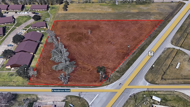
State Highway 35, Angleton, TX 77515


This Property Is For Sale
NEARBY LISTINGS FOR SALE OR LEASE
Property Detail
State Highway 35
Houston-The Woodlands-Sugar Land, TX
T S Lee
0318-0045-110
A0318 T S LEE BLOCK 42 TRACT 42A (U/2) (OLIVER & BARROW SD) ACRES 1.75 (ANGLETON)
Agriculturalland
Brazoria
X
Texas
48039C0435K
42a
2024
1.75 AC
2025
Southwest Far
662100
Houston
DEMOGRAPHICS near State Highway 35
1 Mile
3 Mile
5 Mile
2024 Total Population
5,174
23,459
26,990
2029 Population
5,688
25,928
29,747
Pop Growth 2024-2029
+ 9.93%
+ 10.52%
+ 10.21%
Average Age
39
38
38
2024 Total Households
1,881
8,632
9,867
HH Growth 2024-2029
+ 10.10%
+ 10.73%
+ 10.43%
Median Household Inc
$74,525
$71,402
$72,328
Avg Household Size
2.70
2.70
2.70
2024 Avg HH Vehicles
2.00
2.00
2.00
Median Home Value
$155,762
$176,570
$181,791
Median Year Built
1972
1980
1981
Nearby Places
Map Layers
Map Styles
 Street
 Aerial
- Restaurants
- Banks
- Shops
- Fitness
- Groceries
Nearby Properties
Address
Land Use
TOTAL SIZE
Lot Size
Zoning
Address
Land Use
TOTAL SIZE
Lot Size
Zoning
77.68 AC
0066
Address
Land Use
TOTAL SIZE
Lot Size
Zoning
305,581 SF
8.28 AC
Address
Land Use
TOTAL SIZE
Lot Size
Zoning
318,545 SF
50.52 AC
Address
Land Use
TOTAL SIZE
Lot Size
Zoning
349,628 SF
40 AC
Address
Land Use
TOTAL SIZE
Lot Size
Zoning
4,953 SF
19.41 AC
0151
Address
Land Use
TOTAL SIZE
Lot Size
Zoning
128,857 SF
10.65 AC
0140
Address
Land Use
TOTAL SIZE
Lot Size
Zoning
398,610 SF
119.90 AC
Address
Land Use
TOTAL SIZE
Lot Size
Zoning
138,430 SF
8.85 AC
Address
Land Use
TOTAL SIZE
Lot Size
Zoning
140,993 SF
5.79 AC
Address
Land Use
TOTAL SIZE
Lot Size
Zoning
12,221 SF
13.76 AC
0165
Address
Land Use
TOTAL SIZE
Lot Size
Zoning
89,808 SF
8.80 AC
Address
Land Use
TOTAL SIZE
Lot Size
Zoning
15.45 AC
Address
Land Use
TOTAL SIZE
Lot Size
Zoning
14.46 AC
0138
Address
Land Use
TOTAL SIZE
Lot Size
Zoning
128,247 SF
17.49 AC
0114
Address
Land Use
TOTAL SIZE
Lot Size
Zoning
80,718 SF
5.92 AC
Address
Land Use
TOTAL SIZE
Lot Size
Zoning
36,320 SF
10 AC
098A
Address
Land Use
TOTAL SIZE
Lot Size
Zoning
6.52 AC
Address
Land Use
TOTAL SIZE
Lot Size
Zoning
4.60 AC
Address
Land Use
TOTAL SIZE
Lot Size
Zoning
65,752 SF
Address
Land Use
TOTAL SIZE
Lot Size
Zoning
95,358 SF
4.78 AC
0140
Address
Land Use
TOTAL SIZE
Lot Size
Zoning
60.29 AC
0068
Address
Land Use
TOTAL SIZE
Lot Size
Zoning
77,295 SF
6.63 AC
0056
Address
Land Use
TOTAL SIZE
Lot Size
Zoning
90,957 SF
5 AC
Address
Land Use
TOTAL SIZE
Lot Size
Zoning
Address
Land Use
TOTAL SIZE
Lot Size
Zoning
69,265 SF
3.25 AC
Address
Land Use
TOTAL SIZE
Lot Size
Zoning
52,342 SF
8.63 AC
Address
Land Use
TOTAL SIZE
Lot Size
Zoning
78,046 SF
4 AC
Address
Land Use
TOTAL SIZE
Lot Size
Zoning
57,646 SF
14.52 AC
Address
Land Use
TOTAL SIZE
Lot Size
Zoning
18.91 AC
Address
Land Use
TOTAL SIZE
Lot Size
Zoning
125,915 SF
6.02 AC
The World's #1 Commercial Real Estate Marketplace
Connect with us
© 2025 CoStar Group
The information above has been obtained from sources believed reliable. While we do not doubt its accuracy we have not verified it and make no guarantee, warranty or representation about it. It is your responsibility to independently confirm its accuracy and completeness. Any projections, opinions, assumptions, or estimates used are for example only and do not represent the current or future performance of the property. The value of this transaction to you depends on tax and other factors which should be evaluated by your tax, financial, and legal advisors. You and your advisors should conduct a careful, independent investigation of the property to determine to your satisfaction the suitability of the property for your needs.