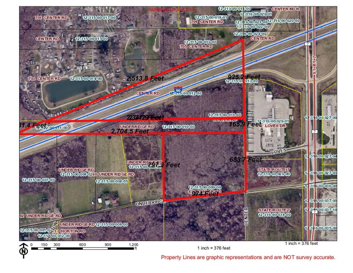
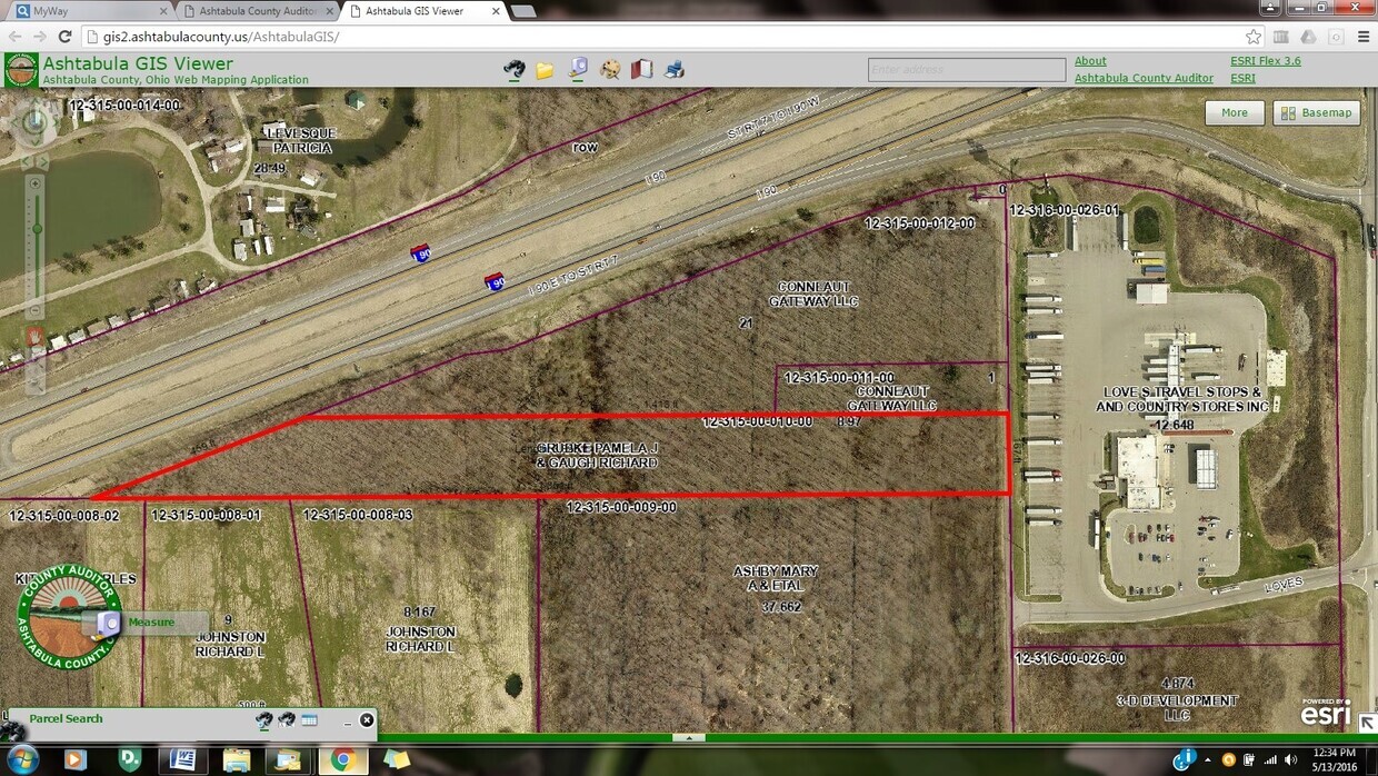
Property Record
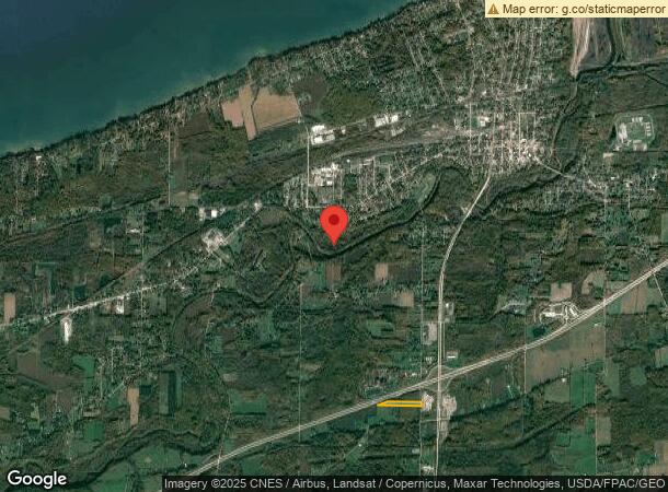
Underridge Rd, Conneaut, OH 44030
This Property Is For Sale
NEARBY LISTINGS FOR SALE OR LEASE
Property Detail
Underridge Rd
Cleveland
Connecticut Western Reserve
Ashtabula, OH
Ashtabula
123150001000
Ohio
Residentialnec
8.97 AC
X
Ashtabula County
42049C0300D
DEMOGRAPHICS near Underridge Rd
1 Mile
3 Mile
5 Mile
2024 Total Population
196
11,395
16,488
2029 Population
193
11,418
16,488
Pop Growth 2024-2029
(1.53%)
+ 0.20%
0.00%
Average Age
46
42
42
2024 Total Households
86
4,147
6,288
HH Growth 2024-2029
(2.33%)
+ 0.14%
(0.06%)
Median Household Inc
$67,000
$50,177
$50,122
Avg Household Size
2.20
2.20
2.20
2024 Avg HH Vehicles
2.00
2.00
2.00
Median Home Value
$151,428
$95,422
$111,304
Median Year Built
1962
1950
1953
Nearby Places
- Restaurants
- Banks
- Shops
- Fitness
- Groceries
PUBLIC TRANSPORTATION
AIRPORT
Erie International/Tom Ridge Field
DRIVE
WALK
Distance
Erie International/Tom Ridge Field
40 min
25.1 mi
Freight Ports
Port of Toledo
DRIVE
WALK
Distance
Port of Toledo
219 min
185.9 mi
Nearby Properties
Address
Land Use
TOTAL SIZE
Lot Size
Zoning
Address
Land Use
TOTAL SIZE
Lot Size
Zoning
196,866 SF
119.64 AC
Address
Land Use
TOTAL SIZE
Lot Size
Zoning
Address
Land Use
TOTAL SIZE
Lot Size
Zoning
94,656 SF
27.89 AC
Address
Land Use
TOTAL SIZE
Lot Size
Zoning
78,100 SF
7.28 AC
Address
Land Use
TOTAL SIZE
Lot Size
Zoning
Address
Land Use
TOTAL SIZE
Lot Size
Zoning
70,523 SF
17.69 AC
Address
Land Use
TOTAL SIZE
Lot Size
Zoning
105,869 SF
6.90 AC
Address
Land Use
TOTAL SIZE
Lot Size
Zoning
4,236 SF
3.59 AC
Address
Land Use
TOTAL SIZE
Lot Size
Zoning
64,728 SF
21.53 AC
Address
Land Use
TOTAL SIZE
Lot Size
Zoning
0.09 AC
Address
Land Use
TOTAL SIZE
Lot Size
Zoning
254,037 SF
16.47 AC
Address
Land Use
TOTAL SIZE
Lot Size
Zoning
57,714 SF
8.65 AC
Address
Land Use
TOTAL SIZE
Lot Size
Zoning
202,939 SF
36.27 AC
Address
Land Use
TOTAL SIZE
Lot Size
Zoning
Address
Land Use
TOTAL SIZE
Lot Size
Zoning
1.01 AC
Address
Land Use
TOTAL SIZE
Lot Size
Zoning
Address
Land Use
TOTAL SIZE
Lot Size
Zoning
213,400 SF
10.02 AC
Address
Land Use
TOTAL SIZE
Lot Size
Zoning
102,157 SF
10 AC
Address
Land Use
TOTAL SIZE
Lot Size
Zoning
75,074 SF
5.61 AC
Address
Land Use
TOTAL SIZE
Lot Size
Zoning
Address
Land Use
TOTAL SIZE
Lot Size
Zoning
98,857 SF
18.62 AC
Address
Land Use
TOTAL SIZE
Lot Size
Zoning
16,103 SF
12.65 AC
Address
Land Use
TOTAL SIZE
Lot Size
Zoning
110,576 SF
17.91 AC
Address
Land Use
TOTAL SIZE
Lot Size
Zoning
31,756 SF
4.34 AC
Address
Land Use
TOTAL SIZE
Lot Size
Zoning
24,142 SF
11.46 AC
Address
Land Use
TOTAL SIZE
Lot Size
Zoning
53,569 SF
8.83 AC
Address
Land Use
TOTAL SIZE
Lot Size
Zoning
16,680 SF
0.90 AC
Address
Land Use
TOTAL SIZE
Lot Size
Zoning
16,872 SF
45.37 AC
Address
Land Use
TOTAL SIZE
Lot Size
Zoning
5,607 SF
16.41 AC
Address
Land Use
TOTAL SIZE
Lot Size
Zoning
83,400 SF
12.13 AC
The World's #1 Commercial Real Estate Marketplace
Connect with us
© 2025 CoStar Group
The information above has been obtained from sources believed reliable. While we do not doubt its accuracy we have not verified it and make no guarantee, warranty or representation about it. It is your responsibility to independently confirm its accuracy and completeness. Any projections, opinions, assumptions, or estimates used are for example only and do not represent the current or future performance of the property. The value of this transaction to you depends on tax and other factors which should be evaluated by your tax, financial, and legal advisors. You and your advisors should conduct a careful, independent investigation of the property to determine to your satisfaction the suitability of the property for your needs.