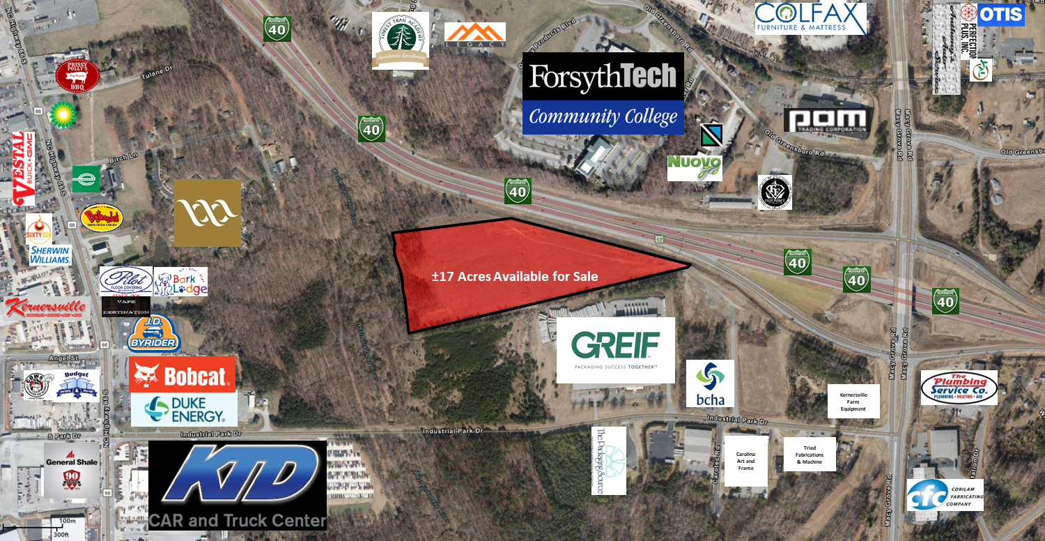
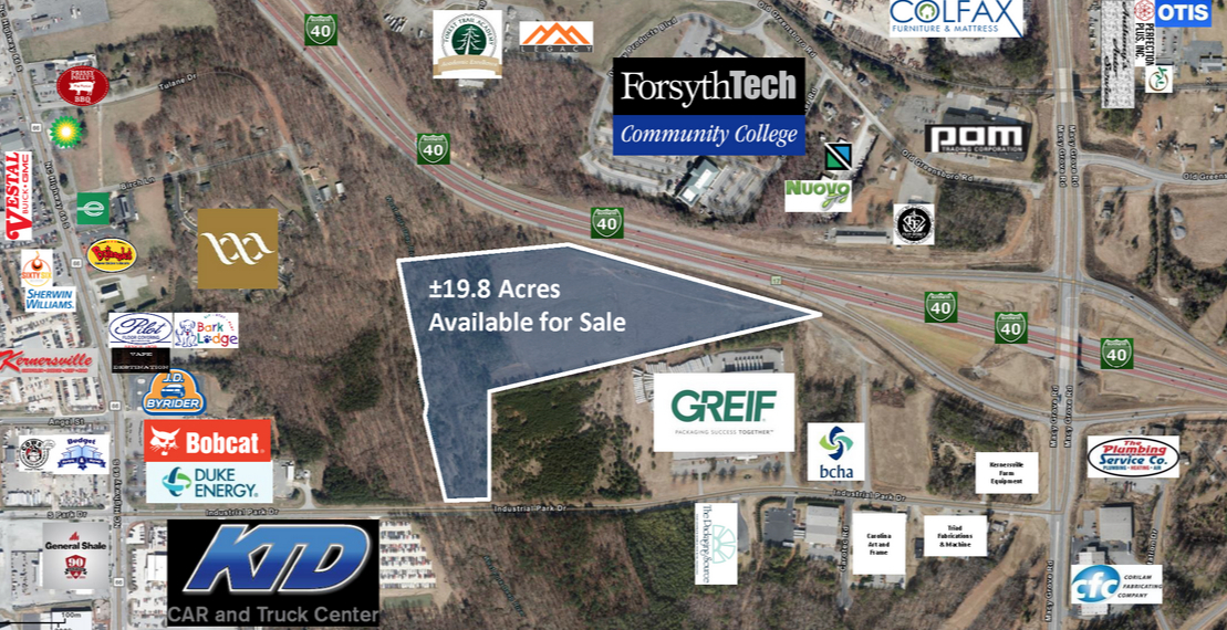
Property Record
Tulane Dr, Kernersville, NC 27284
NEARBY LISTINGS FOR SALE OR LEASE
Property Detail
Tulane Dr
Winston-Salem, NC
Harmon Estates
6885-79-6698
LO016P BL5401
Residentialacreage
Forsyth
X
North Carolina
3710688600J
16p
2023
11.72 AC
2023
Kernersville
003201
Greensboro/Winston-Salem
DEMOGRAPHICS near Tulane Dr
1 Mile
3 Mile
5 Mile
2024 Total Population
1,815
26,957
61,773
2029 Population
1,877
28,017
63,966
Pop Growth 2024-2029
+ 3.42%
+ 3.93%
+ 3.55%
Average Age
41
42
42
2024 Total Households
878
12,006
25,542
HH Growth 2024-2029
+ 3.53%
+ 3.96%
+ 3.62%
Median Household Inc
$42,051
$61,424
$76,897
Avg Household Size
2.00
2.20
2.40
2024 Avg HH Vehicles
2.00
2.00
2.00
Median Home Value
$203,719
$232,705
$244,785
Median Year Built
1983
1988
1992
Nearby Places
- Restaurants
- Banks
- Shops
- Fitness
- Groceries
PUBLIC TRANSPORTATION
AIRPORT
Piedmont Triad International
DRIVE
WALK
Distance
Piedmont Triad International
23 min
11.6 mi
Freight Ports
Virginia Port Authority - Richmond
DRIVE
WALK
Distance
Virginia Port Authority - Richmond
250 min
215.2 mi
SALE & LEASE HISTORY
LISTING DATE
SALE/LEASE

Jun 28, 2019
For Sale
Nearby Properties
Address
Land Use
TOTAL SIZE
Lot Size
Zoning
Address
Land Use
TOTAL SIZE
Lot Size
Zoning
128,008 SF
38.53 AC
MBP
Address
Land Use
TOTAL SIZE
Lot Size
Zoning
184,482 SF
30.31 AC
MBP
Address
Land Use
TOTAL SIZE
Lot Size
Zoning
120,468 SF
22.70 AC
RM18-S
Address
Land Use
TOTAL SIZE
Lot Size
Zoning
679,988 SF
133.50 AC
BI
Address
Land Use
TOTAL SIZE
Lot Size
Zoning
95,878 SF
16.81 AC
MU-S
Address
Land Use
TOTAL SIZE
Lot Size
Zoning
85,411 SF
15.41 AC
MU-S
Address
Land Use
TOTAL SIZE
Lot Size
Zoning
575,802 SF
59.82 AC
GI,LI
Address
Land Use
TOTAL SIZE
Lot Size
Zoning
202,539 SF
23.70 AC
HB-S
Address
Land Use
TOTAL SIZE
Lot Size
Zoning
69,565 SF
19.06 AC
RM18-S
Address
Land Use
TOTAL SIZE
Lot Size
Zoning
128,795 SF
30.33 AC
RM18
Address
Land Use
TOTAL SIZE
Lot Size
Zoning
39,816 SF
11.29 AC
GB-S
Address
Land Use
TOTAL SIZE
Lot Size
Zoning
119,735 SF
14.48 AC
HB-S
Address
Land Use
TOTAL SIZE
Lot Size
Zoning
253,867 SF
39.55 AC
GI
Address
Land Use
TOTAL SIZE
Lot Size
Zoning
136,068 SF
19.46 AC
HB-S
Address
Land Use
TOTAL SIZE
Lot Size
Zoning
105,119 SF
40.18 AC
RS30
Address
Land Use
TOTAL SIZE
Lot Size
Zoning
43,709 SF
9.47 AC
MU-S
Address
Land Use
TOTAL SIZE
Lot Size
Zoning
102,809 SF
16.74 AC
BI
Address
Land Use
TOTAL SIZE
Lot Size
Zoning
603,029 SF
48.87 AC
LI
Address
Land Use
TOTAL SIZE
Lot Size
Zoning
120,807 SF
9.07 AC
HB-S
Address
Land Use
TOTAL SIZE
Lot Size
Zoning
83,774 SF
7.51 AC
GB-S
Address
Land Use
TOTAL SIZE
Lot Size
Zoning
91,461 SF
37.44 AC
RS20
Address
Land Use
TOTAL SIZE
Lot Size
Zoning
74,608 SF
8.68 AC
MBP
Address
Land Use
TOTAL SIZE
Lot Size
Zoning
78,274 SF
27.95 AC
RM8-S
Address
Land Use
TOTAL SIZE
Lot Size
Zoning
508,343 SF
51.60 AC
GI
Address
Land Use
TOTAL SIZE
Lot Size
Zoning
96,091 SF
11.77 AC
MU-S
Address
Land Use
TOTAL SIZE
Lot Size
Zoning
52,480 SF
30.51 AC
BI
Address
Land Use
TOTAL SIZE
Lot Size
Zoning
94,092 SF
15.31 AC
RM18
Address
Land Use
TOTAL SIZE
Lot Size
Zoning
86,726 SF
11.80 AC
HB-S
Address
Land Use
TOTAL SIZE
Lot Size
Zoning
52,792 SF
25.21 AC
AG
Address
Land Use
TOTAL SIZE
Lot Size
Zoning
43,286 SF
3.77 AC
RMU-S
The World's #1 Commercial Real Estate Marketplace
Connect with us
© 2025 CoStar Group
The information above has been obtained from sources believed reliable. While we do not doubt its accuracy we have not verified it and make no guarantee, warranty or representation about it. It is your responsibility to independently confirm its accuracy and completeness. Any projections, opinions, assumptions, or estimates used are for example only and do not represent the current or future performance of the property. The value of this transaction to you depends on tax and other factors which should be evaluated by your tax, financial, and legal advisors. You and your advisors should conduct a careful, independent investigation of the property to determine to your satisfaction the suitability of the property for your needs.