Property Record
Interstate 30, Little Rock, AR 72210
NEARBY LISTINGS FOR SALE OR LEASE
-
-
-
-
Mabelvale West Road And Otter Creek East Blvd @ Otter Creek East Blvd
Mabelvale, AR 72103
$590,000
1.01 AC Lots
Land
-
-
No Photo
-
No Photo
-
View all Little Rock listings for sale on LoopNet.com
Property Detail
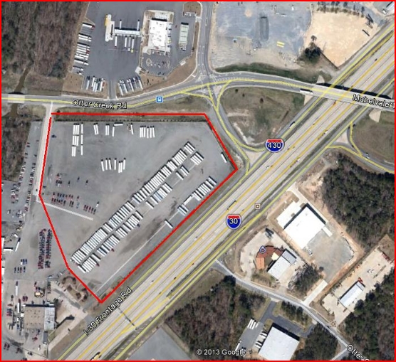
Interstate 30
Little Rock-North Little Rock-Conway, AR
Otter Creek
45L-056-00-011-00
PT NW SECTION 9-1S-13 LYING W OF I-30 & S OF OTTER CREEK RD COM AT THE NW CORNER OF THE NW THENCE S89*2825E273.21 ALONG THE NORTH LINE OF SECTION 9 TO THE POB THENCE S89*2825E260 S244507E289.82 S45*3353W224.17 S45*4217E470.15 S4
Commercialacreage
Pulaski
AE
Arkansas
05125C0250E
7.44 AC
2023
Outlying Pulaski County
2023
Little Rock/N Little Rock
004221
DEMOGRAPHICS near Interstate 30
1 Mile
3 Mile
5 Mile
2024 Total Population
1,267
26,246
72,692
2029 Population
1,230
26,708
74,467
Pop Growth 2024-2029
(2.92%)
+ 1.76%
+ 2.44%
Average Age
39
37
37
2024 Total Households
534
10,407
28,200
HH Growth 2024-2029
(3.00%)
+ 1.57%
+ 2.32%
Median Household Inc
$54,736
$53,190
$55,007
Avg Household Size
2.30
2.50
2.50
2024 Avg HH Vehicles
2.00
2.00
2.00
Median Home Value
$167,999
$151,367
$150,383
Median Year Built
1997
1993
1987
Nearby Places
- Restaurants
- Banks
- Shops
- Fitness
- Groceries
PUBLIC TRANSPORTATION
AIRPORT
Bill and Hillary Clinton Ntl/Adams Field
DRIVE
WALK
Distance
Bill and Hillary Clinton Ntl/Adams Field
19 min
13.8 mi
Freight Ports
Port of Shreveport
DRIVE
WALK
Distance
Port of Shreveport
236 min
221.6 mi
SALE & LEASE HISTORY
LISTING DATE
SALE/LEASE

Sep 24, 2016
For Sale
Jul 03, 2017
For Sale
Nearby Properties
Address
Land Use
TOTAL SIZE
Lot Size
Zoning
Address
Land Use
TOTAL SIZE
Lot Size
Zoning
400,000 SF
57.75 AC
Address
Land Use
TOTAL SIZE
Lot Size
Zoning
177,413 SF
24.66 AC
Address
Land Use
TOTAL SIZE
Lot Size
Zoning
317,302 SF
44.38 AC
Address
Land Use
TOTAL SIZE
Lot Size
Zoning
26,199 SF
19.22 AC
Address
Land Use
TOTAL SIZE
Lot Size
Zoning
201,039 SF
161.29 AC
Address
Land Use
TOTAL SIZE
Lot Size
Zoning
13,888 SF
21.57 AC
Address
Land Use
TOTAL SIZE
Lot Size
Zoning
83,022 SF
6.20 AC
Address
Land Use
TOTAL SIZE
Lot Size
Zoning
365,104 SF
29.75 AC
Address
Land Use
TOTAL SIZE
Lot Size
Zoning
104,359 SF
14.63 AC
Address
Land Use
TOTAL SIZE
Lot Size
Zoning
13,952 SF
12.35 AC
Address
Land Use
TOTAL SIZE
Lot Size
Zoning
12,420 SF
12.25 AC
Address
Land Use
TOTAL SIZE
Lot Size
Zoning
7,937 SF
5.50 AC
Address
Land Use
TOTAL SIZE
Lot Size
Zoning
8,510 SF
13.20 AC
Address
Land Use
TOTAL SIZE
Lot Size
Zoning
201,499 SF
17.80 AC
Address
Land Use
TOTAL SIZE
Lot Size
Zoning
16,957 SF
6.49 AC
Address
Land Use
TOTAL SIZE
Lot Size
Zoning
45,600 SF
6.45 AC
Address
Land Use
TOTAL SIZE
Lot Size
Zoning
189,160 SF
40.53 AC
Address
Land Use
TOTAL SIZE
Lot Size
Zoning
30,356 SF
5.42 AC
Address
Land Use
TOTAL SIZE
Lot Size
Zoning
11,762 SF
9.05 AC
Address
Land Use
TOTAL SIZE
Lot Size
Zoning
11,252 SF
2.69 AC
Address
Land Use
TOTAL SIZE
Lot Size
Zoning
71,581 SF
10.15 AC
Address
Land Use
TOTAL SIZE
Lot Size
Zoning
309,271 SF
41.75 AC
Address
Land Use
TOTAL SIZE
Lot Size
Zoning
7,482 SF
6.58 AC
Address
Land Use
TOTAL SIZE
Lot Size
Zoning
7,950 SF
8.74 AC
Address
Land Use
TOTAL SIZE
Lot Size
Zoning
44,567 SF
9.58 AC
Address
Land Use
TOTAL SIZE
Lot Size
Zoning
6,282 SF
58.79 AC
Address
Land Use
TOTAL SIZE
Lot Size
Zoning
162,970 SF
12.66 AC
Address
Land Use
TOTAL SIZE
Lot Size
Zoning
26,864 SF
7.96 AC
Address
Land Use
TOTAL SIZE
Lot Size
Zoning
20,440 SF
5.61 AC
Address
Land Use
TOTAL SIZE
Lot Size
Zoning
51.50 AC
The World's #1 Commercial Real Estate Marketplace
Connect with us
© 2025 CoStar Group
The information above has been obtained from sources believed reliable. While we do not doubt its accuracy we have not verified it and make no guarantee, warranty or representation about it. It is your responsibility to independently confirm its accuracy and completeness. Any projections, opinions, assumptions, or estimates used are for example only and do not represent the current or future performance of the property. The value of this transaction to you depends on tax and other factors which should be evaluated by your tax, financial, and legal advisors. You and your advisors should conduct a careful, independent investigation of the property to determine to your satisfaction the suitability of the property for your needs.