Property Record
Iron Ridge Rd, Rocky Mount, VA 24151

This Property Is For Sale
Property Detail
Iron Ridge Rd
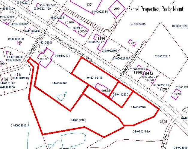
0440102300
WIRTZ SUBD
Commercialacreage
FRANKLIN
B2
Virginia
B and X Area of moderate flood hazard, usually the area between the limits of the 100-year and 500-year floods.
8.91 AC
2025
North Franklin County
2025
Roanoke
020801
Roanoke, VA
NEARBY LISTINGS FOR SALE OR LEASE
DEMOGRAPHICS near Iron Ridge Rd
1 mile
3 mile
5 mile
2025 Total Population
643
3,940
11,563
2030 Population
633
3,884
11,412
Pop Growth 2025-2030
(1.56%)
(1.42%)
(1.31%)
Average Age
42
42
43
2025 Total Households
260
1,599
4,819
HH Growth 2025-2030
(1.92%)
(1.63%)
(1.56%)
Median Household Inc
$71,938
$73,652
$64,793
Avg Household Size
2.50
2.40
2.30
2025 Avg HH Vehicles
2.00
2.00
2.00
Median Home Value
$224,510
$234,195
$215,719
Median Year Built
1984
1981
1979
Nearby Places
Map Layers
Map Styles
 Street
 Aerial
Layers
 Traffic
 Biking
Places
Listings with unknown addresses are not visible on the map
- Restaurants
- Banks
- Shops
- Fitness
- Groceries
PUBLIC TRANSPORTATION
AIRPORT
Roanoke/Blacksburg Regional (Woodrum Field)
Drive
Walk
Distance
Roanoke/Blacksburg Regional (Woodrum Field)
35 min
25.0 mi
Freight Ports
Virginia Port Authority - Richmond
Drive
Walk
Distance
Virginia Port Authority - Richmond
230 min
166.2 mi
Nearby Properties
Address
Land Use
TOTAL SIZE
Lot Size
Zoning
Address
Land Use
TOTAL SIZE
Lot Size
Zoning
50,216 SF
7.91 AC
B2
Address
Land Use
TOTAL SIZE
Lot Size
Zoning
115,920 SF
7.62 AC
SM
Address
Land Use
TOTAL SIZE
Lot Size
Zoning
39,172 SF
8.73 AC
A1
Address
Land Use
TOTAL SIZE
Lot Size
Zoning
21,012 SF
8.60 AC
REP
Address
Land Use
TOTAL SIZE
Lot Size
Zoning
6,760 SF
2.75 AC
SM
Address
Land Use
TOTAL SIZE
Lot Size
Zoning
5,000 SF
32.72 AC
SM
Address
Land Use
TOTAL SIZE
Lot Size
Zoning
14.54 AC
A1
Address
Land Use
TOTAL SIZE
Lot Size
Zoning
18,750 SF
2.41 AC
PCD
Address
Land Use
TOTAL SIZE
Lot Size
Zoning
56,000 SF
13.73 AC
B2
Address
Land Use
TOTAL SIZE
Lot Size
Zoning
30,100 SF
2.76 AC
SM
Address
Land Use
TOTAL SIZE
Lot Size
Zoning
51,280 SF
5.64 AC
B2
Address
Land Use
TOTAL SIZE
Lot Size
Zoning
6,621 SF
7.25 AC
SM
Address
Land Use
TOTAL SIZE
Lot Size
Zoning
16,112 SF
8 AC
B2
Address
Land Use
TOTAL SIZE
Lot Size
Zoning
28,990 SF
1.90 AC
B2
Address
Land Use
TOTAL SIZE
Lot Size
Zoning
50,400 SF
8.89 AC
REP
Address
Land Use
TOTAL SIZE
Lot Size
Zoning
16,200 SF
3.45 AC
Address
Land Use
TOTAL SIZE
Lot Size
Zoning
36,200 SF
2.30 AC
B2
Address
Land Use
TOTAL SIZE
Lot Size
Zoning
15,280 SF
16.48 AC
B2
Address
Land Use
TOTAL SIZE
Lot Size
Zoning
11,032 SF
1.80 AC
PCD
Address
Land Use
TOTAL SIZE
Lot Size
Zoning
9,220 SF
2.43 AC
B2
Address
Land Use
TOTAL SIZE
Lot Size
Zoning
13,422 SF
5.90 AC
A1
Address
Land Use
TOTAL SIZE
Lot Size
Zoning
3.39 AC
B2
Address
Land Use
TOTAL SIZE
Lot Size
Zoning
9,400 SF
11.88 AC
B2
Address
Land Use
TOTAL SIZE
Lot Size
Zoning
3,524 SF
3.94 AC
B2
Address
Land Use
TOTAL SIZE
Lot Size
Zoning
39.91 AC
SM
Address
Land Use
TOTAL SIZE
Lot Size
Zoning
7,800 SF
1.83 AC
A1
Address
Land Use
TOTAL SIZE
Lot Size
Zoning
21,416 SF
71.64 AC
M1
Address
Land Use
TOTAL SIZE
Lot Size
Zoning
30,000 SF
2.07 AC
M1
Address
Land Use
TOTAL SIZE
Lot Size
Zoning
5,210 SF
1.96 AC
B1
Address
Land Use
TOTAL SIZE
Lot Size
Zoning
The World's #1 Commercial Real Estate Marketplace
Connect with us
© 2026 CoStar Group
The information above has been obtained from sources believed reliable. While we do not doubt its accuracy we have not verified it and make no guarantee, warranty or representation about it. It is your responsibility to independently confirm its accuracy and completeness. Any projections, opinions, assumptions, or estimates used are for example only and do not represent the current or future performance of the property. The value of this transaction to you depends on tax and other factors which should be evaluated by your tax, financial, and legal advisors. You and your advisors should conduct a careful, independent investigation of the property to determine to your satisfaction the suitability of the property for your needs.