Property Record
Jordan Rd, Manvel, TX 77578
NEARBY LISTINGS FOR SALE OR LEASE
Property Detail
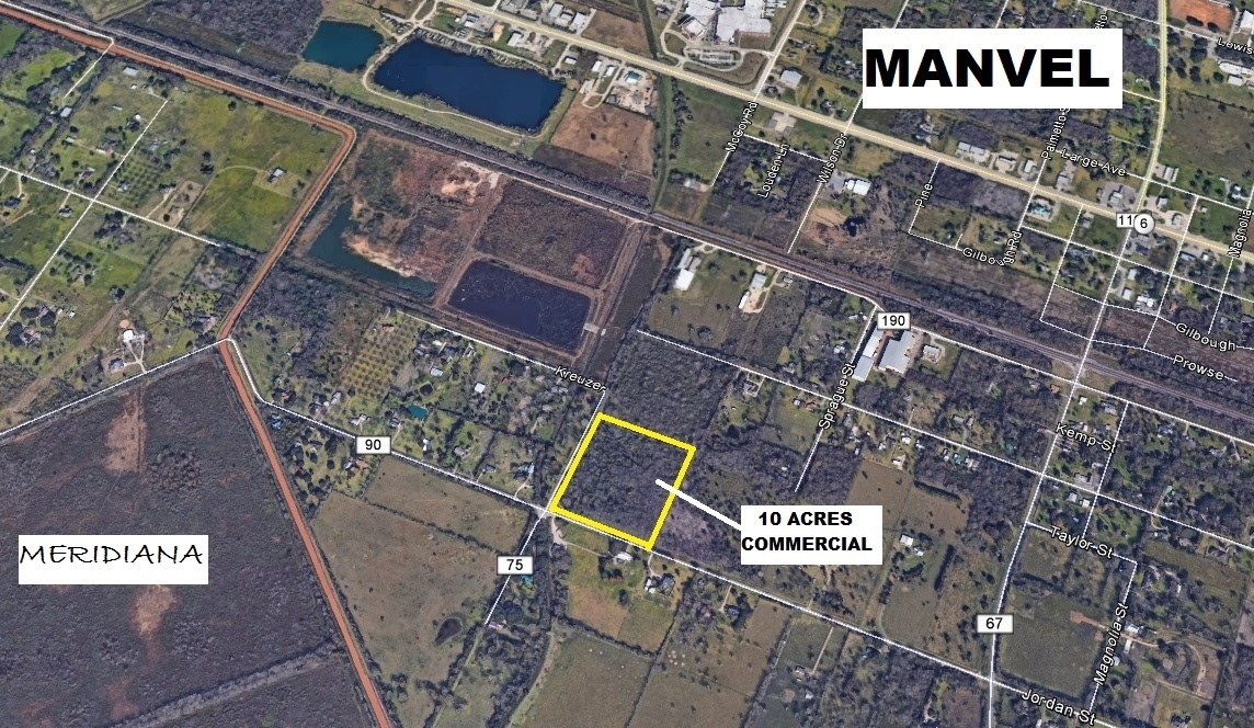
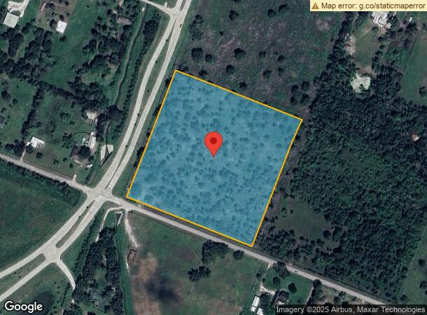
Jordan Rd
Houston-The Woodlands-Sugar Land, TX
Manvel
6398-0139-000
MANVEL LOT OL 72 ACRES 10.
Agriculturalland
Brazoria
AO
Texas
48039C0130K
72
2023
10 AC
2023
South Hwy 35
660702
Houston
DEMOGRAPHICS near Jordan Rd
1 Mile
3 Mile
5 Mile
2024 Total Population
818
10,722
43,786
2029 Population
910
12,367
49,945
Pop Growth 2024-2029
+ 11.25%
+ 15.34%
+ 14.07%
Average Age
40
38
36
2024 Total Households
288
3,661
14,123
HH Growth 2024-2029
+ 11.11%
+ 15.49%
+ 14.21%
Median Household Inc
$92,456
$101,118
$93,675
Avg Household Size
2.80
2.90
3.00
2024 Avg HH Vehicles
3.00
2.00
2.00
Median Home Value
$354,878
$315,896
$313,811
Median Year Built
1992
2010
2010
Nearby Places
- Restaurants
- Banks
- Shops
- Fitness
- Groceries
PUBLIC TRANSPORTATION
AIRPORT
William P Hobby
DRIVE
WALK
Distance
William P Hobby
33 min
16.9 mi
Freight Ports
Port of Houston
DRIVE
WALK
Distance
Port of Houston
39 min
27.4 mi
SALE & LEASE HISTORY
LISTING DATE
SALE/LEASE

Jun 05, 2017
For Sale
Nearby Properties
Address
Land Use
TOTAL SIZE
Lot Size
Zoning
Address
Land Use
TOTAL SIZE
Lot Size
Zoning
114.04 AC
Address
Land Use
TOTAL SIZE
Lot Size
Zoning
125,750 SF
28.32 AC
Address
Land Use
TOTAL SIZE
Lot Size
Zoning
120,380 SF
15.56 AC
Address
Land Use
TOTAL SIZE
Lot Size
Zoning
93,990 SF
15.73 AC
Address
Land Use
TOTAL SIZE
Lot Size
Zoning
21.99 AC
0258
Address
Land Use
TOTAL SIZE
Lot Size
Zoning
70,033 SF
17.97 AC
Address
Land Use
TOTAL SIZE
Lot Size
Zoning
172,015 SF
18.36 AC
Address
Land Use
TOTAL SIZE
Lot Size
Zoning
17.17 AC
Address
Land Use
TOTAL SIZE
Lot Size
Zoning
28,708 SF
9.57 AC
Address
Land Use
TOTAL SIZE
Lot Size
Zoning
28,083 SF
13.08 AC
Address
Land Use
TOTAL SIZE
Lot Size
Zoning
214,827 SF
15.70 AC
0033
Address
Land Use
TOTAL SIZE
Lot Size
Zoning
94,094 SF
5.86 AC
Address
Land Use
TOTAL SIZE
Lot Size
Zoning
136.01 AC
0003
Address
Land Use
TOTAL SIZE
Lot Size
Zoning
21,300 SF
12.92 AC
Address
Land Use
TOTAL SIZE
Lot Size
Zoning
48,750 SF
2.82 AC
Address
Land Use
TOTAL SIZE
Lot Size
Zoning
25,200 SF
5.08 AC
Address
Land Use
TOTAL SIZE
Lot Size
Zoning
11,628 SF
1.86 AC
0009
Address
Land Use
TOTAL SIZE
Lot Size
Zoning
3,159 SF
64.95 AC
0227
Address
Land Use
TOTAL SIZE
Lot Size
Zoning
29,625 SF
2.01 AC
Address
Land Use
TOTAL SIZE
Lot Size
Zoning
50,400 SF
4.23 AC
0013
Address
Land Use
TOTAL SIZE
Lot Size
Zoning
12,240 SF
1.46 AC
0240
Address
Land Use
TOTAL SIZE
Lot Size
Zoning
14,768 SF
1.30 AC
Address
Land Use
TOTAL SIZE
Lot Size
Zoning
7,788 SF
2.03 AC
Address
Land Use
TOTAL SIZE
Lot Size
Zoning
134.41 AC
Address
Land Use
TOTAL SIZE
Lot Size
Zoning
9,298 SF
3.22 AC
Address
Land Use
TOTAL SIZE
Lot Size
Zoning
9,020 SF
3.12 AC
Address
Land Use
TOTAL SIZE
Lot Size
Zoning
3,257 SF
105.54 AC
0428
Address
Land Use
TOTAL SIZE
Lot Size
Zoning
14,360 SF
1.68 AC
Address
Land Use
TOTAL SIZE
Lot Size
Zoning
13,750 SF
12.42 AC
0222
Address
Land Use
TOTAL SIZE
Lot Size
Zoning
25,613 SF
10.11 AC
0034
The World's #1 Commercial Real Estate Marketplace
Connect with us
© 2025 CoStar Group
The information above has been obtained from sources believed reliable. While we do not doubt its accuracy we have not verified it and make no guarantee, warranty or representation about it. It is your responsibility to independently confirm its accuracy and completeness. Any projections, opinions, assumptions, or estimates used are for example only and do not represent the current or future performance of the property. The value of this transaction to you depends on tax and other factors which should be evaluated by your tax, financial, and legal advisors. You and your advisors should conduct a careful, independent investigation of the property to determine to your satisfaction the suitability of the property for your needs.