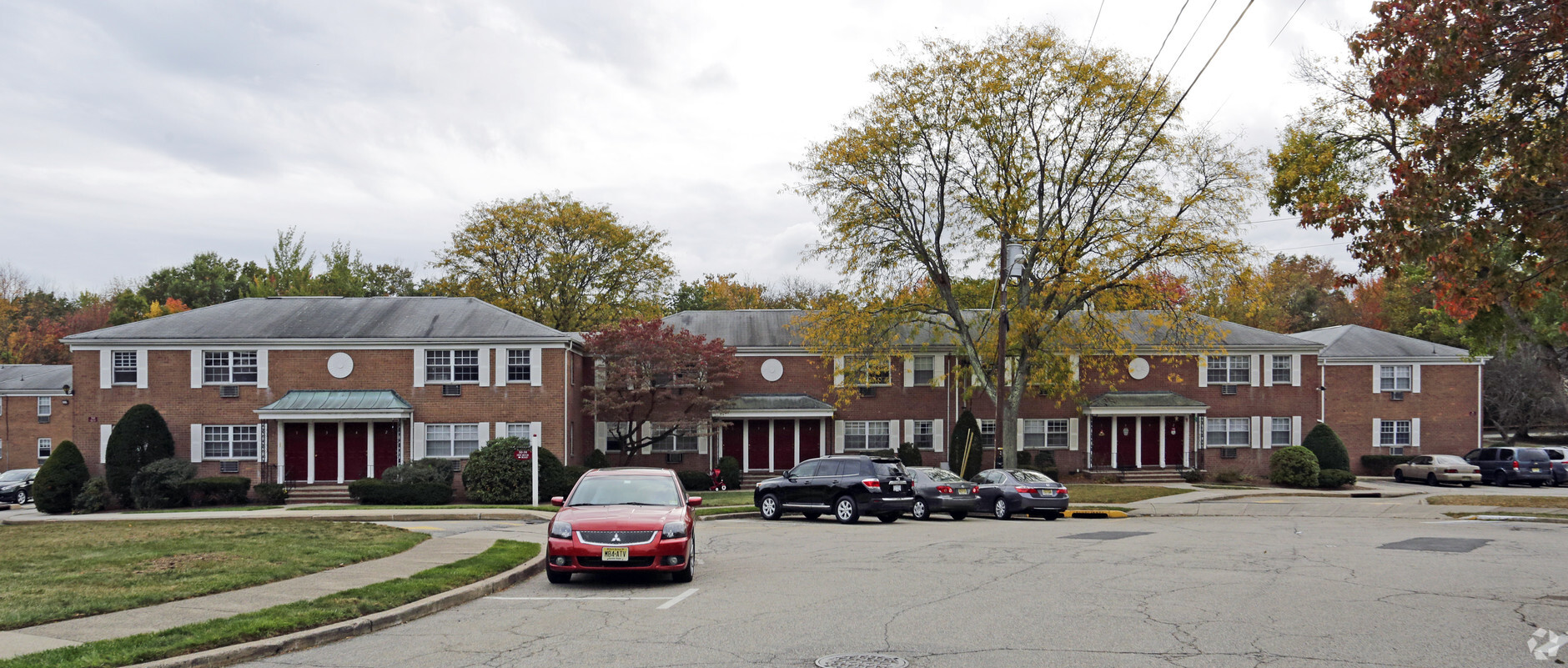
Property Record
Kinderkamack R, Westwood, NJ 07675
NEARBY LISTINGS FOR SALE OR LEASE
-
-
View all Westwood listings for sale on LoopNet.com
Property Detail
Kinderkamack R
New York-Jersey City-White Plains, NY-NJ
4.5AC
67-01503-0000-00019
Bergen
Apartment
New Jersey
X
19
34003C0182H
4.50 AC
2023
Greater Bergen County
2024
Northern New Jersey
049002
DEMOGRAPHICS near Kinderkamack R
1 Mile
3 Mile
5 Mile
2024 Total Population
16,209
83,198
268,280
2029 Population
16,129
83,027
267,736
Pop Growth 2024-2029
(0.49%)
(0.21%)
(0.20%)
Average Age
42
43
42
2024 Total Households
6,023
28,754
91,674
HH Growth 2024-2029
(0.58%)
(0.29%)
(0.25%)
Median Household Inc
$130,919
$146,530
$136,986
Avg Household Size
2.60
2.80
2.80
2024 Avg HH Vehicles
2.00
2.00
2.00
Median Home Value
$591,115
$681,976
$664,047
Median Year Built
1956
1959
1958
Nearby Places
- Restaurants
- Banks
- Shops
- Fitness
- Groceries
PUBLIC TRANSPORTATION
COMMUTER RAIL
Westwood (Pascack Valley Line - NJ Transit Commuter Rail (NJ Transit))
Drive
Walk
Distance
Westwood (Pascack Valley Line - NJ Transit Commuter Rail (NJ Transit))
1 min
10 min
0.4 mi
Emerson (Pascack Valley Line - NJ Transit Commuter Rail (NJ Transit))
Drive
Walk
Distance
Emerson (Pascack Valley Line - NJ Transit Commuter Rail (NJ Transit))
1 min
20 min
1.1 mi
AIRPORT
Laguardia
Drive
Walk
Distance
Laguardia
37 min
23.1 mi
Newark Liberty International
Drive
Walk
Distance
Newark Liberty International
33 min
25.8 mi
Westchester County
Drive
Walk
Distance
Westchester County
44 min
30.2 mi
Freight Ports
NY - Red Hook Container Terminal
Drive
Walk
Distance
NY - Red Hook Container Terminal
46 min
27.0 mi
Nearby Properties
Address
Land Use
TOTAL SIZE
Lot Size
Zoning
Address
Land Use
TOTAL SIZE
Lot Size
Zoning
45191
3.11 AC
BL
Address
Land Use
TOTAL SIZE
Lot Size
Zoning
19.96 AC
HSO
Address
Land Use
TOTAL SIZE
Lot Size
Zoning
232368
5.10 AC
Address
Land Use
TOTAL SIZE
Lot Size
Zoning
296562
20.49 AC
BIL
Address
Land Use
TOTAL SIZE
Lot Size
Zoning
8.78 AC
HSO
Address
Land Use
TOTAL SIZE
Lot Size
Zoning
Address
Land Use
TOTAL SIZE
Lot Size
Zoning
23572
98.75 AC
CR
Address
Land Use
TOTAL SIZE
Lot Size
Zoning
9.20 AC
OR
Address
Land Use
TOTAL SIZE
Lot Size
Zoning
156877
12.60 AC
BG
Address
Land Use
TOTAL SIZE
Lot Size
Zoning
47623
88.60 AC
B
Address
Land Use
TOTAL SIZE
Lot Size
Zoning
21.74 AC
SC
Address
Land Use
TOTAL SIZE
Lot Size
Zoning
45269
5.66 AC
BG
Address
Land Use
TOTAL SIZE
Lot Size
Zoning
192486
11.82 AC
BL
Address
Land Use
TOTAL SIZE
Lot Size
Zoning
82.73 AC
Address
Land Use
TOTAL SIZE
Lot Size
Zoning
110814
10 AC
BG
Address
Land Use
TOTAL SIZE
Lot Size
Zoning
161352
14.02 AC
BG
Address
Land Use
TOTAL SIZE
Lot Size
Zoning
144868
11.14 AC
BG
Address
Land Use
TOTAL SIZE
Lot Size
Zoning
57890
26.61 AC
R100
Address
Land Use
TOTAL SIZE
Lot Size
Zoning
1620
37.22 AC
R225
Address
Land Use
TOTAL SIZE
Lot Size
Zoning
845.02 AC
Address
Land Use
TOTAL SIZE
Lot Size
Zoning
3.33 AC
R3
Address
Land Use
TOTAL SIZE
Lot Size
Zoning
15065
9.30 AC
RC
Address
Land Use
TOTAL SIZE
Lot Size
Zoning
31892
15.55 AC
R100
Address
Land Use
TOTAL SIZE
Lot Size
Zoning
191950
43.03 AC
RA25
Address
Land Use
TOTAL SIZE
Lot Size
Zoning
8.12 AC
BIL
Address
Land Use
TOTAL SIZE
Lot Size
Zoning
34971
11.35 AC
R75
Address
Land Use
TOTAL SIZE
Lot Size
Zoning
62728
14.49 AC
RA15
Address
Land Use
TOTAL SIZE
Lot Size
Zoning
5.37 AC
B2
Address
Land Use
TOTAL SIZE
Lot Size
Zoning
10.94 AC
AA
Address
Land Use
TOTAL SIZE
Lot Size
Zoning
144751
22.87 AC
RA
Start a new search to find other properties for sale or lease
Connect with us
© 2024 CoStar Group
The information above has been obtained from sources believed reliable. While we do not doubt its accuracy we have not verified it and make no guarantee, warranty or representation about it. It is your responsibility to independently confirm its accuracy and completeness. Any projections, opinions, assumptions, or estimates used are for example only and do not represent the current or future performance of the property. The value of this transaction to you depends on tax and other factors which should be evaluated by your tax, financial, and legal advisors. You and your advisors should conduct a careful, independent investigation of the property to determine to your satisfaction the suitability of the property for your needs.