Property Record
Knox Rd, Sacramento, CA 95829

This Property Is For Sale
Property Detail
Knox Rd
Sacramento-Roseville-Folsom, CA
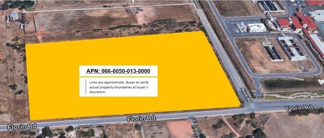
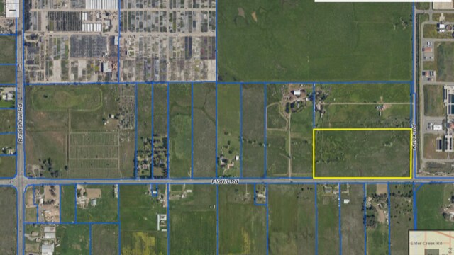
PARCEL MAP, LOT D
066-0050-013
SACRAMENTO
Residentialacreage
California
AG-160 (SM
d
B and X Area of moderate flood hazard, usually the area between the limits of the 100-year and 500-year floods.
18.98 AC
2024
Outer Sacramento County
2025
Sacramento
009311
NEARBY LISTINGS FOR SALE OR LEASE
DEMOGRAPHICS near Knox Rd
1 mile
3 mile
5 mile
2025 Total Population
138
20,781
116,861
2030 Population
130
21,315
118,216
Pop Growth 2025-2030
(5.80%)
+ 2.57%
+ 1.16%
Average Age
42
40
39
2025 Total Households
41
6,171
36,640
HH Growth 2025-2030
(4.88%)
+ 2.59%
+ 1.20%
Median Household Inc
$63,750
$126,116
$96,718
Avg Household Size
3.00
3.30
3.10
2025 Avg HH Vehicles
3.00
2.00
2.00
Median Home Value
$1,032,143
$729,161
$515,271
Median Year Built
1956
2006
1989
Nearby Places
Map Layers
Map Styles
 Street
 Aerial
Layers
 Traffic
 Biking
Places
Listings with unknown addresses are not visible on the map
- Restaurants
- Banks
- Shops
- Fitness
- Groceries
PUBLIC TRANSPORTATION
AIRPORT
Sacramento International
Drive
Walk
Distance
Sacramento International
36 min
25.1 mi
Freight Ports
Port of Stockton
Drive
Walk
Distance
Port of Stockton
59 min
45.6 mi
Nearby Properties
Address
Land Use
TOTAL SIZE
Lot Size
Zoning
Address
Land Use
TOTAL SIZE
Lot Size
Zoning
12.04 AC
M-1S-R
Address
Land Use
TOTAL SIZE
Lot Size
Zoning
161,834 SF
15.23 AC
LC
Address
Land Use
TOTAL SIZE
Lot Size
Zoning
167,152 SF
7.53 AC
RD-20
Address
Land Use
TOTAL SIZE
Lot Size
Zoning
800 SF
2.43 AC
M-1 (SM)
Address
Land Use
TOTAL SIZE
Lot Size
Zoning
RD-5 O RD-
Address
Land Use
TOTAL SIZE
Lot Size
Zoning
7,659 SF
191.35 AC
M-1
Address
Land Use
TOTAL SIZE
Lot Size
Zoning
150,807 SF
19.85 AC
M-1
Address
Land Use
TOTAL SIZE
Lot Size
Zoning
14,423 SF
9.60 AC
AR-10
Address
Land Use
TOTAL SIZE
Lot Size
Zoning
39.69 AC
RD-3 RD-5
Address
Land Use
TOTAL SIZE
Lot Size
Zoning
5,000 SF
161.69 AC
AG-80
Address
Land Use
TOTAL SIZE
Lot Size
Zoning
36,270 SF
15.88 AC
M-1
Address
Land Use
TOTAL SIZE
Lot Size
Zoning
3,088 SF
1.32 AC
M-1S-R
Address
Land Use
TOTAL SIZE
Lot Size
Zoning
720 SF
38.04 AC
AR-10
Address
Land Use
TOTAL SIZE
Lot Size
Zoning
25,200 SF
1.91 AC
M-2S-R
Address
Land Use
TOTAL SIZE
Lot Size
Zoning
3,027 SF
158 AC
AG-80 (SM)
Address
Land Use
TOTAL SIZE
Lot Size
Zoning
43.50 AC
M-1 (SM)
Address
Land Use
TOTAL SIZE
Lot Size
Zoning
1,188 SF
36.09 AC
SC
Address
Land Use
TOTAL SIZE
Lot Size
Zoning
31.90 AC
M-1
Address
Land Use
TOTAL SIZE
Lot Size
Zoning
14,400 SF
3.54 AC
M-1
Address
Land Use
TOTAL SIZE
Lot Size
Zoning
15.79 AC
LC
Address
Land Use
TOTAL SIZE
Lot Size
Zoning
28,800 SF
2 AC
M-2S-R
Address
Land Use
TOTAL SIZE
Lot Size
Zoning
5.78 AC
LC
Address
Land Use
TOTAL SIZE
Lot Size
Zoning
10,354 SF
4.76 AC
M-1
Address
Land Use
TOTAL SIZE
Lot Size
Zoning
1,528 SF
9.95 AC
RD-7
Address
Land Use
TOTAL SIZE
Lot Size
Zoning
5,160 SF
10.10 AC
M-1
Address
Land Use
TOTAL SIZE
Lot Size
Zoning
1,680 SF
31.90 AC
M-1
Address
Land Use
TOTAL SIZE
Lot Size
Zoning
4.01 AC
M-1
Address
Land Use
TOTAL SIZE
Lot Size
Zoning
2,281 SF
213.43 AC
AG-80 (SM)
Address
Land Use
TOTAL SIZE
Lot Size
Zoning
3.92 AC
M-1
Address
Land Use
TOTAL SIZE
Lot Size
Zoning
40 AC
AG-20 RD-7
The World's #1 Commercial Real Estate Marketplace
Connect with us
© 2026 CoStar Group
The information above has been obtained from sources believed reliable. While we do not doubt its accuracy we have not verified it and make no guarantee, warranty or representation about it. It is your responsibility to independently confirm its accuracy and completeness. Any projections, opinions, assumptions, or estimates used are for example only and do not represent the current or future performance of the property. The value of this transaction to you depends on tax and other factors which should be evaluated by your tax, financial, and legal advisors. You and your advisors should conduct a careful, independent investigation of the property to determine to your satisfaction the suitability of the property for your needs.