Property Record
L2a Brindle Rd, Harrisburg, PA 17110

NEARBY LISTINGS FOR SALE OR LEASE
Property Detail
L2a Brindle Rd
62-023-083
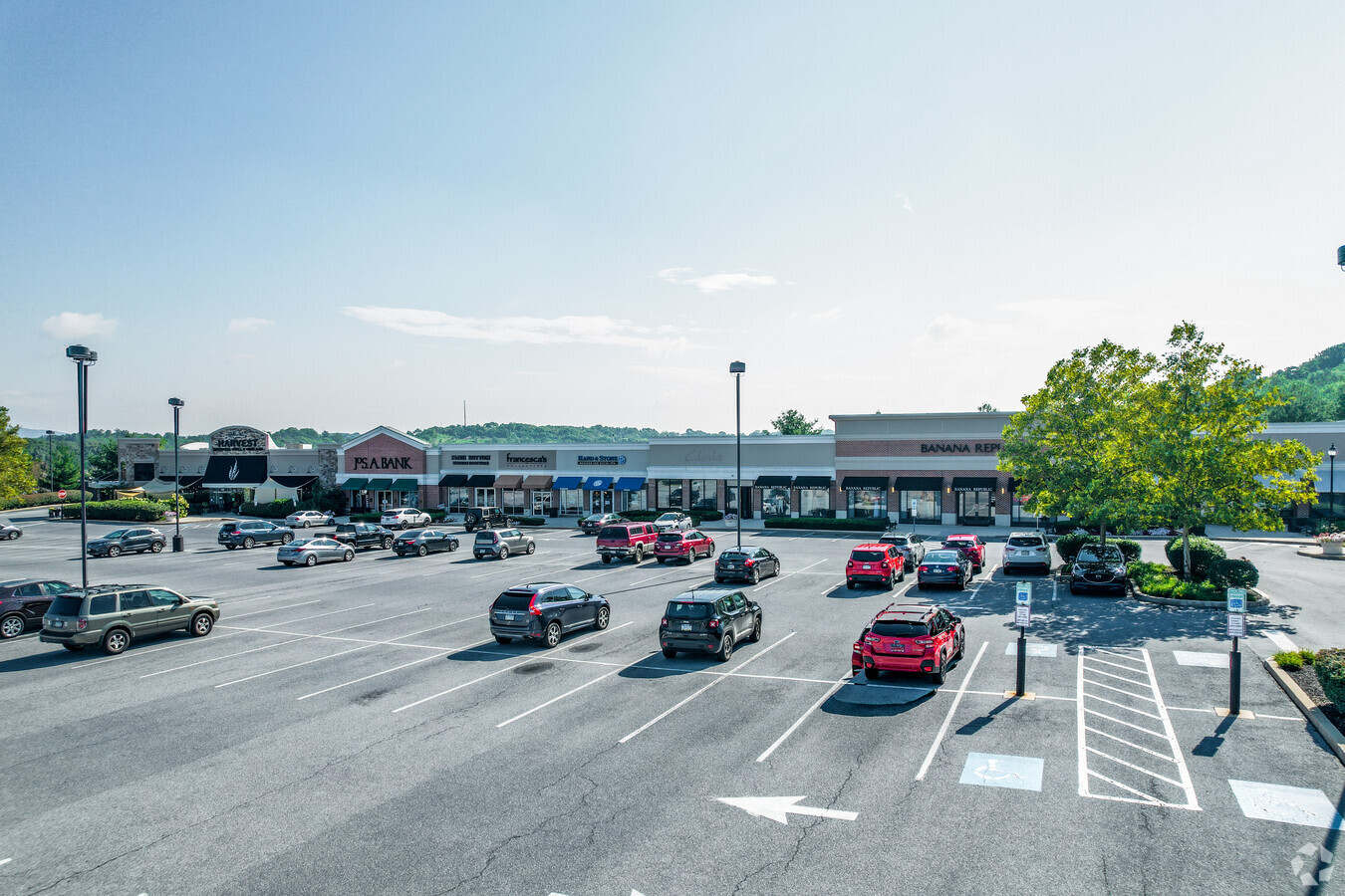
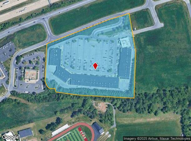
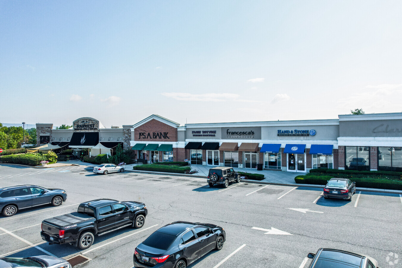
Susquehanna Marketplace
Stripcommercialcenter
Dauphin
X
Pennsylvania
42043C0340D
11.77 AC
2024
Harrisburg Area East
2024
Philadelphia
021904
Harrisburg-Carlisle, PA
29,125 SF
DEMOGRAPHICS near L2a Brindle Rd
1 Mile
3 Mile
5 Mile
2024 Total Population
9,115
85,364
183,896
2029 Population
9,298
87,395
189,024
Pop Growth 2024-2029
+ 2.01%
+ 2.38%
+ 2.79%
Average Age
39
40
40
2024 Total Households
4,017
34,857
76,024
HH Growth 2024-2029
+ 2.09%
+ 2.42%
+ 2.95%
Median Household Inc
$60,756
$62,396
$63,539
Avg Household Size
2.20
2.40
2.30
2024 Avg HH Vehicles
1.00
2.00
2.00
Median Home Value
$179,797
$180,638
$183,559
Median Year Built
1973
1965
1965
Nearby Places
- Restaurants
- Banks
- Shops
- Fitness
- Groceries
PUBLIC TRANSPORTATION
COMMUTER RAIL
Harrisburg (Keystone Service - Amtrak, Pennsylvanian - Amtrak)
DRIVE
WALK
Distance
Harrisburg (Keystone Service - Amtrak, Pennsylvanian - Amtrak)
12 min
5.2 mi
AIRPORT
Harrisburg International
DRIVE
WALK
Distance
Harrisburg International
21 min
12.6 mi
Freight Ports
Port of Baltimore
DRIVE
WALK
Distance
Port of Baltimore
119 min
85.4 mi
SALE & LEASE HISTORY
LISTING DATE
SALE/LEASE

Mar 17, 2023
For Lease
Nearby Properties
Address
Land Use
TOTAL SIZE
Lot Size
Zoning
Address
Land Use
TOTAL SIZE
Lot Size
Zoning
615,797 SF
59.70 AC
Address
Land Use
TOTAL SIZE
Lot Size
Zoning
3,025 SF
274.13 AC
Address
Land Use
TOTAL SIZE
Lot Size
Zoning
210,464 SF
28.80 AC
Address
Land Use
TOTAL SIZE
Lot Size
Zoning
577,075 SF
39.55 AC
Address
Land Use
TOTAL SIZE
Lot Size
Zoning
74,032 SF
74.81 AC
Address
Land Use
TOTAL SIZE
Lot Size
Zoning
638,721 SF
47.78 AC
Address
Land Use
TOTAL SIZE
Lot Size
Zoning
130,542 SF
28.94 AC
Address
Land Use
TOTAL SIZE
Lot Size
Zoning
9,188 SF
46.70 AC
Address
Land Use
TOTAL SIZE
Lot Size
Zoning
2,913 SF
24.28 AC
Address
Land Use
TOTAL SIZE
Lot Size
Zoning
47,022 SF
47.55 AC
Address
Land Use
TOTAL SIZE
Lot Size
Zoning
125,255 SF
26.65 AC
Address
Land Use
TOTAL SIZE
Lot Size
Zoning
284,737 SF
28.16 AC
Address
Land Use
TOTAL SIZE
Lot Size
Zoning
192,390 SF
43.19 AC
Address
Land Use
TOTAL SIZE
Lot Size
Zoning
2,000 SF
21.13 AC
Address
Land Use
TOTAL SIZE
Lot Size
Zoning
242,534 SF
47.26 AC
Address
Land Use
TOTAL SIZE
Lot Size
Zoning
228,141 SF
42.50 AC
Address
Land Use
TOTAL SIZE
Lot Size
Zoning
112,388 SF
38.01 AC
Address
Land Use
TOTAL SIZE
Lot Size
Zoning
226,101 SF
46.29 AC
Address
Land Use
TOTAL SIZE
Lot Size
Zoning
31,240 SF
20.25 AC
Address
Land Use
TOTAL SIZE
Lot Size
Zoning
33,916 SF
10 AC
Address
Land Use
TOTAL SIZE
Lot Size
Zoning
2,823 SF
36.87 AC
Address
Land Use
TOTAL SIZE
Lot Size
Zoning
207,012 SF
24.50 AC
Address
Land Use
TOTAL SIZE
Lot Size
Zoning
1,989 SF
16.62 AC
Address
Land Use
TOTAL SIZE
Lot Size
Zoning
139,381 SF
42.61 AC
Address
Land Use
TOTAL SIZE
Lot Size
Zoning
665,098 SF
14 AC
Address
Land Use
TOTAL SIZE
Lot Size
Zoning
13,348 SF
25.38 AC
Address
Land Use
TOTAL SIZE
Lot Size
Zoning
66,864 SF
26.25 AC
Address
Land Use
TOTAL SIZE
Lot Size
Zoning
Address
Land Use
TOTAL SIZE
Lot Size
Zoning
97,887 SF
11.90 AC
Address
Land Use
TOTAL SIZE
Lot Size
Zoning
9.88 AC
The World's #1 Commercial Real Estate Marketplace
Connect with us
© 2025 CoStar Group
The information above has been obtained from sources believed reliable. While we do not doubt its accuracy we have not verified it and make no guarantee, warranty or representation about it. It is your responsibility to independently confirm its accuracy and completeness. Any projections, opinions, assumptions, or estimates used are for example only and do not represent the current or future performance of the property. The value of this transaction to you depends on tax and other factors which should be evaluated by your tax, financial, and legal advisors. You and your advisors should conduct a careful, independent investigation of the property to determine to your satisfaction the suitability of the property for your needs.