Property Record
Linwood St, Leander, TX 78641
NEARBY LISTINGS FOR SALE OR LEASE
Property Detail
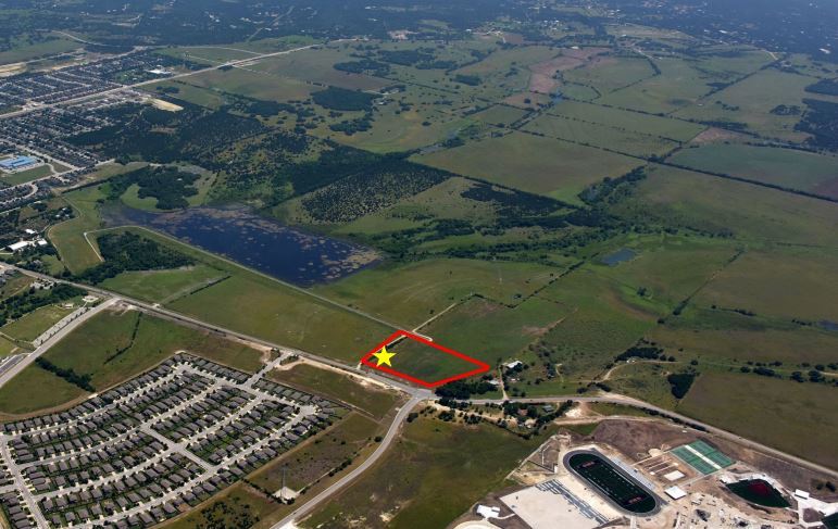
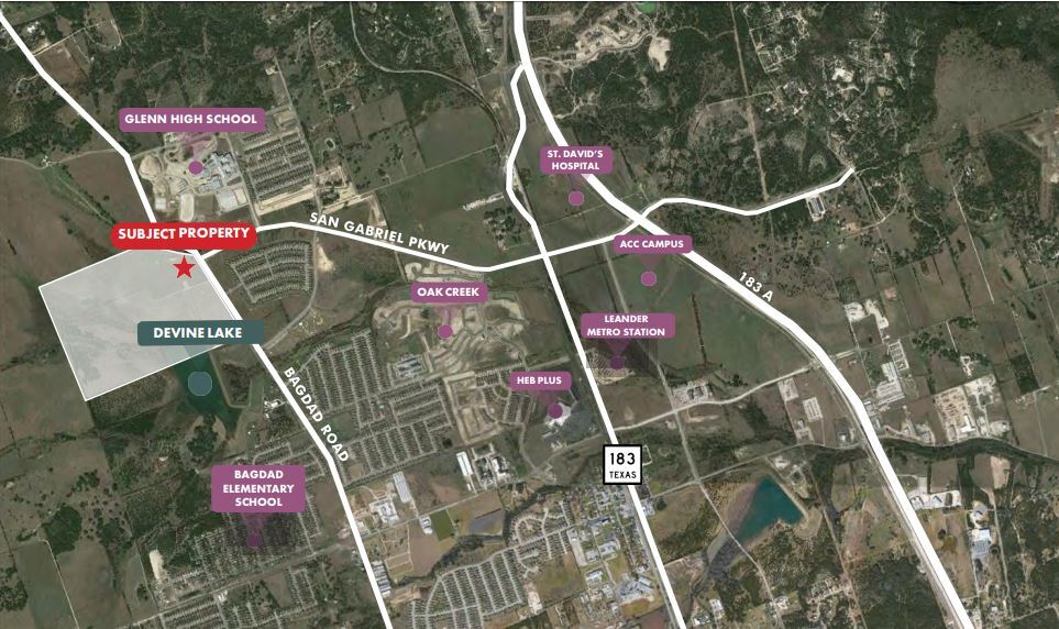
Linwood St
Georgetown
Devine Lake Ph 1
Austin
Williamson
Austin-Round Rock, TX
Texas
R600112
1.77 AC
Notresolvable
DEMOGRAPHICS near Linwood St
1 Mile
3 Mile
5 Mile
2024 Total Population
5,152
43,189
110,660
2029 Population
6,664
55,858
139,875
Pop Growth 2024-2029
+ 29.35%
+ 29.33%
+ 26.40%
Average Age
36
36
36
2024 Total Households
1,763
14,819
37,521
HH Growth 2024-2029
+ 30.01%
+ 29.94%
+ 27.05%
Median Household Inc
$97,565
$99,784
$112,478
Avg Household Size
2.90
2.90
2.90
2024 Avg HH Vehicles
2.00
2.00
2.00
Median Home Value
$372,825
$363,108
$406,825
Median Year Built
2010
2010
2010
Nearby Places
- Restaurants
- Banks
- Shops
- Fitness
- Groceries
PUBLIC TRANSPORTATION
AIRPORT
Austin-Bergstrom International
DRIVE
WALK
Distance
Austin-Bergstrom International
53 min
37.2 mi
Freight Ports
Calhoun Port
DRIVE
WALK
Distance
Calhoun Port
218 min
180.7 mi
SALE & LEASE HISTORY
LISTING DATE
SALE/LEASE

Mar 08, 2022
For Sale
Nearby Properties
Address
Land Use
TOTAL SIZE
Lot Size
Zoning
Address
Land Use
TOTAL SIZE
Lot Size
Zoning
435,000 SF
88.77 AC
Address
Land Use
TOTAL SIZE
Lot Size
Zoning
106,000 SF
72.50 AC
Address
Land Use
TOTAL SIZE
Lot Size
Zoning
341,700 SF
17.71 AC
Address
Land Use
TOTAL SIZE
Lot Size
Zoning
238,420 SF
13.72 AC
Address
Land Use
TOTAL SIZE
Lot Size
Zoning
327,784 SF
22.95 AC
Address
Land Use
TOTAL SIZE
Lot Size
Zoning
327,784 SF
22.95 AC
Address
Land Use
TOTAL SIZE
Lot Size
Zoning
258,463 SF
41.47 AC
Address
Land Use
TOTAL SIZE
Lot Size
Zoning
246,060 SF
9.30 AC
Address
Land Use
TOTAL SIZE
Lot Size
Zoning
232,172 SF
10.43 AC
Address
Land Use
TOTAL SIZE
Lot Size
Zoning
287,118 SF
9.26 AC
Address
Land Use
TOTAL SIZE
Lot Size
Zoning
234,214 SF
19.63 AC
Address
Land Use
TOTAL SIZE
Lot Size
Zoning
117,076 SF
15.52 AC
Address
Land Use
TOTAL SIZE
Lot Size
Zoning
238,343 SF
12.08 AC
Address
Land Use
TOTAL SIZE
Lot Size
Zoning
195,426 SF
12.11 AC
Address
Land Use
TOTAL SIZE
Lot Size
Zoning
193,011 SF
8.91 AC
Address
Land Use
TOTAL SIZE
Lot Size
Zoning
193,600 SF
70.78 AC
Address
Land Use
TOTAL SIZE
Lot Size
Zoning
191,654 SF
4.57 AC
2-LI
Address
Land Use
TOTAL SIZE
Lot Size
Zoning
285,365 SF
9.65 AC
Address
Land Use
TOTAL SIZE
Lot Size
Zoning
310,297 SF
15.01 AC
Address
Land Use
TOTAL SIZE
Lot Size
Zoning
94,861 SF
12.72 AC
Address
Land Use
TOTAL SIZE
Lot Size
Zoning
264,140 SF
21.37 AC
Address
Land Use
TOTAL SIZE
Lot Size
Zoning
194,695 SF
9.56 AC
Address
Land Use
TOTAL SIZE
Lot Size
Zoning
99,909 SF
8.23 AC
Address
Land Use
TOTAL SIZE
Lot Size
Zoning
129,115 SF
5.83 AC
Address
Land Use
TOTAL SIZE
Lot Size
Zoning
121,524 SF
9.34 AC
Address
Land Use
TOTAL SIZE
Lot Size
Zoning
240,800 SF
17.16 AC
Address
Land Use
TOTAL SIZE
Lot Size
Zoning
20.47 AC
Address
Land Use
TOTAL SIZE
Lot Size
Zoning
185,652 SF
10 AC
Address
Land Use
TOTAL SIZE
Lot Size
Zoning
163.59 AC
Address
Land Use
TOTAL SIZE
Lot Size
Zoning
60 AC
1-SFU
The World's #1 Commercial Real Estate Marketplace
Connect with us
© 2025 CoStar Group
The information above has been obtained from sources believed reliable. While we do not doubt its accuracy we have not verified it and make no guarantee, warranty or representation about it. It is your responsibility to independently confirm its accuracy and completeness. Any projections, opinions, assumptions, or estimates used are for example only and do not represent the current or future performance of the property. The value of this transaction to you depends on tax and other factors which should be evaluated by your tax, financial, and legal advisors. You and your advisors should conduct a careful, independent investigation of the property to determine to your satisfaction the suitability of the property for your needs.