Property Record
Marks Rd, Mansfield, GA 30055
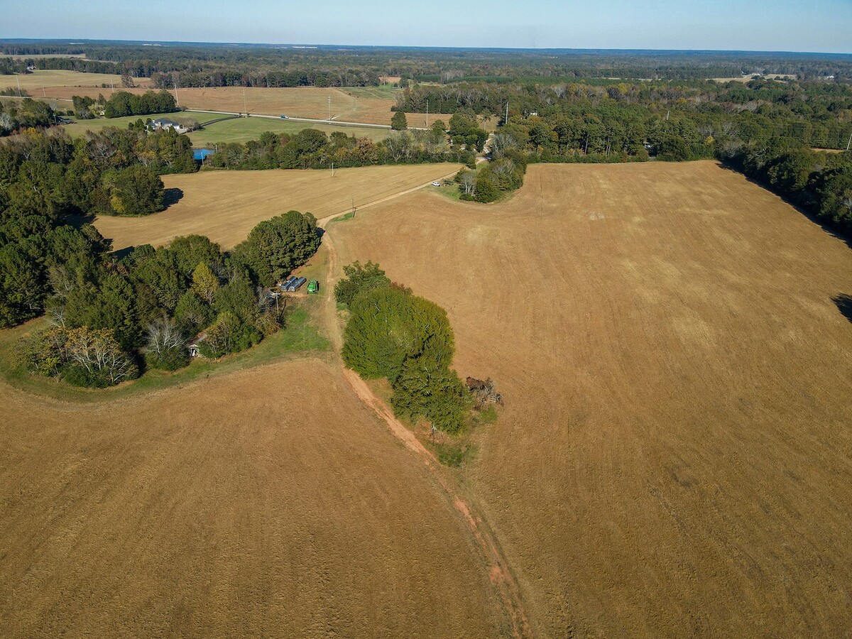
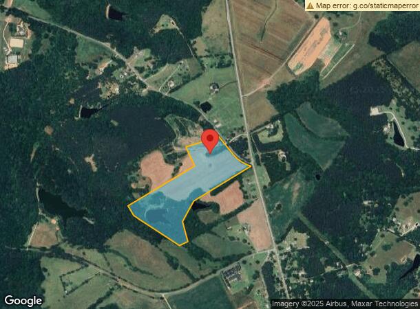
This Property Is For Sale
NEARBY LISTINGS FOR SALE OR LEASE
-
-
View all Mansfield listings for sale on LoopNet.com
Property Detail
Marks Rd
Atlanta-Sandy Springs-Roswell, GA
Map 127, 128, 129
0128000000026000
39.65 AC MARKS ROAD
Privatepreserveopenspacevacantlandforestlandconservation
Newton
X
Georgia
13211C0175B
39.65 AC
2024
Newton County
2024
Atlanta
100203
DEMOGRAPHICS near Marks Rd
1 Mile
3 Mile
5 Mile
2024 Total Population
385
2,886
10,061
2029 Population
430
3,215
11,199
Pop Growth 2024-2029
+ 11.69%
+ 11.40%
+ 11.31%
Average Age
41
40
40
2024 Total Households
134
1,035
3,552
HH Growth 2024-2029
+ 11.94%
+ 11.69%
+ 11.54%
Median Household Inc
$112,500
$103,771
$99,693
Avg Household Size
2.80
2.70
2.80
2024 Avg HH Vehicles
2.00
2.00
2.00
Median Home Value
$303,000
$294,702
$320,629
Median Year Built
1995
1992
1996
Nearby Places
- Restaurants
- Banks
- Shops
- Fitness
- Groceries
Nearby Properties
Address
Land Use
TOTAL SIZE
Lot Size
Zoning
Address
Land Use
TOTAL SIZE
Lot Size
Zoning
250.57 AC
Address
Land Use
TOTAL SIZE
Lot Size
Zoning
49,742 SF
6.52 AC
E6
Address
Land Use
TOTAL SIZE
Lot Size
Zoning
30,600 SF
13.74 AC
Address
Land Use
TOTAL SIZE
Lot Size
Zoning
19,016 SF
21.46 AC
E2
Address
Land Use
TOTAL SIZE
Lot Size
Zoning
21,826 SF
2.74 AC
Address
Land Use
TOTAL SIZE
Lot Size
Zoning
36,470 SF
25.16 AC
I1
Address
Land Use
TOTAL SIZE
Lot Size
Zoning
184 AC
A
Address
Land Use
TOTAL SIZE
Lot Size
Zoning
9,020 SF
1.32 AC
Address
Land Use
TOTAL SIZE
Lot Size
Zoning
173.40 AC
A
Address
Land Use
TOTAL SIZE
Lot Size
Zoning
7,052 SF
1.35 AC
C1
Address
Land Use
TOTAL SIZE
Lot Size
Zoning
15,850 SF
10 AC
I1
Address
Land Use
TOTAL SIZE
Lot Size
Zoning
22 AC
MHP
Address
Land Use
TOTAL SIZE
Lot Size
Zoning
157.87 AC
A
Address
Land Use
TOTAL SIZE
Lot Size
Zoning
4,200 SF
2 AC
C1
Address
Land Use
TOTAL SIZE
Lot Size
Zoning
2,844 SF
184.31 AC
A1
Address
Land Use
TOTAL SIZE
Lot Size
Zoning
7,920 SF
1.60 AC
C1
Address
Land Use
TOTAL SIZE
Lot Size
Zoning
117.12 AC
A
Address
Land Use
TOTAL SIZE
Lot Size
Zoning
84.90 AC
AR
Address
Land Use
TOTAL SIZE
Lot Size
Zoning
4,164 SF
2.48 AC
C1
Address
Land Use
TOTAL SIZE
Lot Size
Zoning
125.37 AC
A
Address
Land Use
TOTAL SIZE
Lot Size
Zoning
123.97 AC
A
Address
Land Use
TOTAL SIZE
Lot Size
Zoning
1,850 SF
69.13 AC
A1
Address
Land Use
TOTAL SIZE
Lot Size
Zoning
71.68 AC
A1
Address
Land Use
TOTAL SIZE
Lot Size
Zoning
54.41 AC
AR
Address
Land Use
TOTAL SIZE
Lot Size
Zoning
38,416 SF
3.72 AC
C1
Address
Land Use
TOTAL SIZE
Lot Size
Zoning
60.87 AC
A
Address
Land Use
TOTAL SIZE
Lot Size
Zoning
3,192 SF
3.16 AC
C1
Address
Land Use
TOTAL SIZE
Lot Size
Zoning
1,820 SF
53.51 AC
A
Address
Land Use
TOTAL SIZE
Lot Size
Zoning
58.44 AC
The World's #1 Commercial Real Estate Marketplace
Connect with us
© 2025 CoStar Group
The information above has been obtained from sources believed reliable. While we do not doubt its accuracy we have not verified it and make no guarantee, warranty or representation about it. It is your responsibility to independently confirm its accuracy and completeness. Any projections, opinions, assumptions, or estimates used are for example only and do not represent the current or future performance of the property. The value of this transaction to you depends on tax and other factors which should be evaluated by your tax, financial, and legal advisors. You and your advisors should conduct a careful, independent investigation of the property to determine to your satisfaction the suitability of the property for your needs.