Property Record
5105 Mcfarland Blvd, Northport, AL 35476
NEARBY LISTINGS FOR SALE OR LEASE
Property Detail
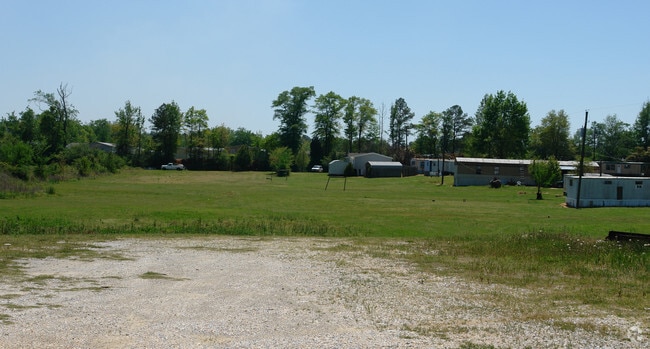
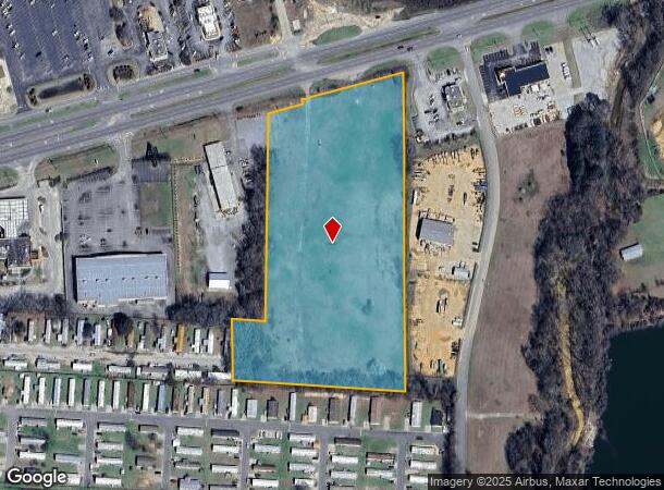
5105 Mcfarland Blvd
31-03-08-3-004-003.000
START AT THE NW COR OF SW 1/4 OF SEC 8 AND R E 1545 ALONG SEC LINE, TH S 730' TO S MARGIN OF H/W 82 FOR P.O.B. TH NE 106, TH N 15', TH NE 314', TH S 934.6, TH W 520', TH N 190 (S), TH E 100, TH N 620' TO P.O.B
Vacantlandnec
Tuscaloosa
X
Alabama
01125C0501G
8.60 AC
2025
Tuscaloosa
2024
Birmingham
010403
Tuscaloosa, AL
DEMOGRAPHICS near 5105 Mcfarland Blvd
1 Mile
3 Mile
5 Mile
2024 Total Population
2,897
28,733
93,149
2029 Population
3,258
32,497
104,127
Pop Growth 2024-2029
+ 12.46%
+ 13.10%
+ 11.79%
Average Age
39
40
34
2024 Total Households
1,103
11,526
33,086
HH Growth 2024-2029
+ 12.06%
+ 12.93%
+ 14.33%
Median Household Inc
$63,171
$60,106
$44,018
Avg Household Size
2.50
2.20
2.20
2024 Avg HH Vehicles
2.00
2.00
2.00
Median Home Value
$170,164
$197,642
$216,133
Median Year Built
1989
1984
1988
Nearby Places
Map Layers
Map Styles
 Street
 Aerial
- Restaurants
- Banks
- Shops
- Fitness
- Groceries
PUBLIC TRANSPORTATION
COMMUTER RAIL
Tuscaloosa Amtrak Station (Crescent - Amtrak)
DRIVE
WALK
Distance
Tuscaloosa Amtrak Station (Crescent - Amtrak)
9 min
4.9 mi
Freight Ports
Port of Mobile
DRIVE
WALK
Distance
Port of Mobile
244 min
201.7 mi
Nearby Properties
Address
Land Use
TOTAL SIZE
Lot Size
Zoning
Address
Land Use
TOTAL SIZE
Lot Size
Zoning
148,656 SF
2.79 AC
BC
Address
Land Use
TOTAL SIZE
Lot Size
Zoning
1.33 AC
BC
Address
Land Use
TOTAL SIZE
Lot Size
Zoning
24,360 SF
142 AC
Address
Land Use
TOTAL SIZE
Lot Size
Zoning
121,384 SF
21 AC
O-I
Address
Land Use
TOTAL SIZE
Lot Size
Zoning
174,000 SF
28.67 AC
R1
Address
Land Use
TOTAL SIZE
Lot Size
Zoning
173,452 SF
2.30 AC
ML
Address
Land Use
TOTAL SIZE
Lot Size
Zoning
110,000 SF
5.80 AC
RD
Address
Land Use
TOTAL SIZE
Lot Size
Zoning
26,576 SF
2.53 AC
RD
Address
Land Use
TOTAL SIZE
Lot Size
Zoning
15.30 AC
Address
Land Use
TOTAL SIZE
Lot Size
Zoning
12,048 SF
21 AC
RM2
Address
Land Use
TOTAL SIZE
Lot Size
Zoning
361,935 SF
133.67 AC
MH
Address
Land Use
TOTAL SIZE
Lot Size
Zoning
301,560 SF
15 AC
ML
Address
Land Use
TOTAL SIZE
Lot Size
Zoning
10,852 SF
46 AC
I
Address
Land Use
TOTAL SIZE
Lot Size
Zoning
73,848 SF
1.73 AC
BGO
Address
Land Use
TOTAL SIZE
Lot Size
Zoning
96,885 SF
2.34 AC
RD
Address
Land Use
TOTAL SIZE
Lot Size
Zoning
10,440 SF
12 AC
Address
Land Use
TOTAL SIZE
Lot Size
Zoning
32,640 SF
9.80 AC
C6
Address
Land Use
TOTAL SIZE
Lot Size
Zoning
143,038 SF
36 AC
O-I
Address
Land Use
TOTAL SIZE
Lot Size
Zoning
7,752 SF
11 AC
R4
Address
Land Use
TOTAL SIZE
Lot Size
Zoning
50,652 SF
19.03 AC
ML
Address
Land Use
TOTAL SIZE
Lot Size
Zoning
4.51 AC
BC
Address
Land Use
TOTAL SIZE
Lot Size
Zoning
73,904 SF
0.97 AC
BC
Address
Land Use
TOTAL SIZE
Lot Size
Zoning
3,808 SF
10 AC
R4
Address
Land Use
TOTAL SIZE
Lot Size
Zoning
15,060 SF
11 AC
RM2
Address
Land Use
TOTAL SIZE
Lot Size
Zoning
91,231 SF
7.71 AC
ML
Address
Land Use
TOTAL SIZE
Lot Size
Zoning
59,039 SF
1.35 AC
RD
Address
Land Use
TOTAL SIZE
Lot Size
Zoning
208,996 SF
25 AC
C-6
Address
Land Use
TOTAL SIZE
Lot Size
Zoning
24,684 SF
12 AC
RM2
Address
Land Use
TOTAL SIZE
Lot Size
Zoning
140,412 SF
14.35 AC
C6
Address
Land Use
TOTAL SIZE
Lot Size
Zoning
213,549 SF
8.80 AC
ML
The World's #1 Commercial Real Estate Marketplace
Connect with us
© 2026 CoStar Group
The information above has been obtained from sources believed reliable. While we do not doubt its accuracy we have not verified it and make no guarantee, warranty or representation about it. It is your responsibility to independently confirm its accuracy and completeness. Any projections, opinions, assumptions, or estimates used are for example only and do not represent the current or future performance of the property. The value of this transaction to you depends on tax and other factors which should be evaluated by your tax, financial, and legal advisors. You and your advisors should conduct a careful, independent investigation of the property to determine to your satisfaction the suitability of the property for your needs.