Property Record
Mill Creek Pkwy, Lagrange, GA 30241
NEARBY LISTINGS FOR SALE OR LEASE
Property Detail
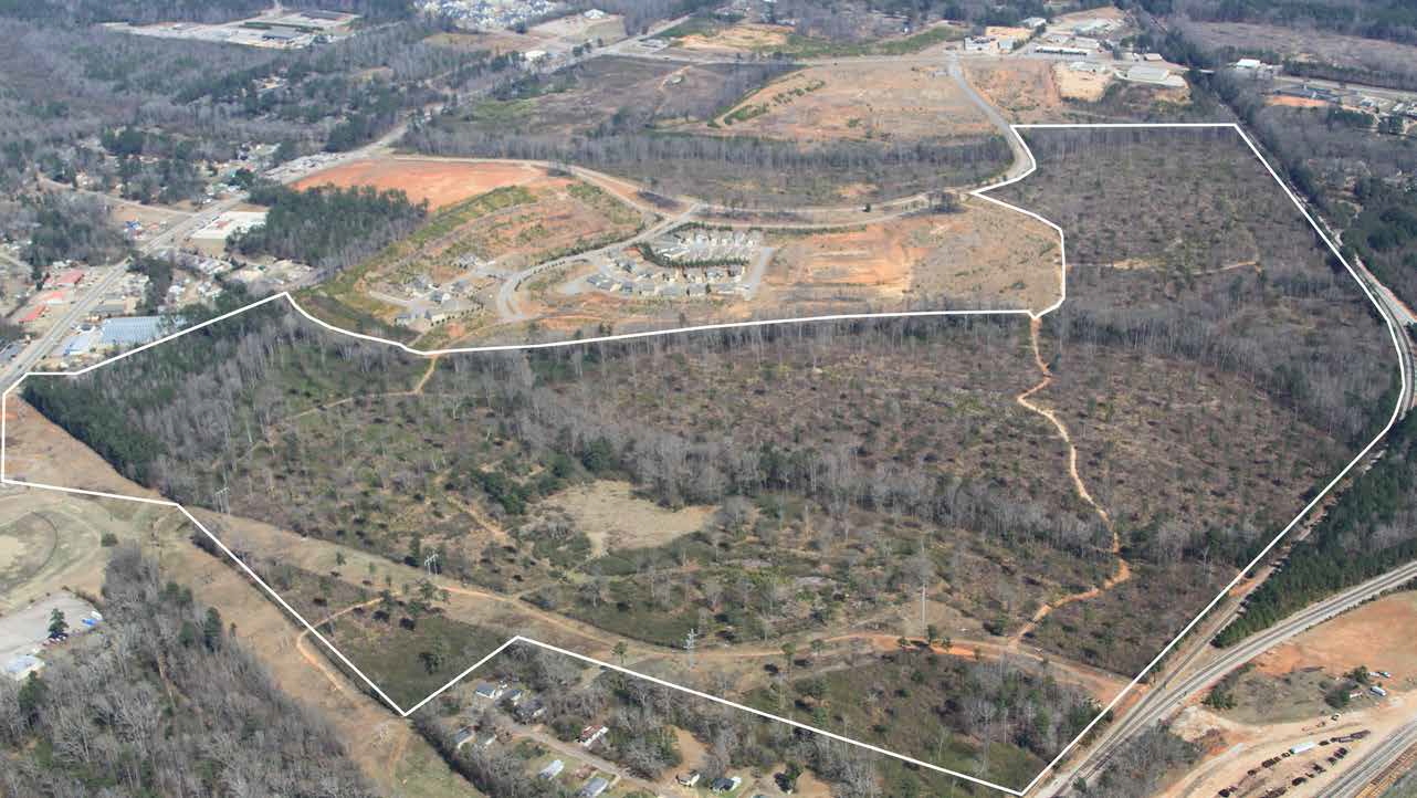
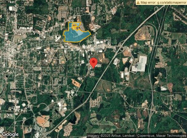
Mill Creek Pkwy
LaGrange, GA
Mill Creek
050-1D-000-001
MILL CREEK PKWY TR-2 PB70 PG220
Commercialacreage
Troup
AE
Georgia
13285C0161E
88
2024
217.08 AC
2024
Troup County
960600
Columbus GA
DEMOGRAPHICS near Mill Creek Pkwy
1 Mile
3 Mile
5 Mile
2024 Total Population
4,489
26,261
38,109
2029 Population
4,584
26,765
38,837
Pop Growth 2024-2029
+ 2.12%
+ 1.92%
+ 1.91%
Average Age
37
37
38
2024 Total Households
1,770
10,419
14,654
HH Growth 2024-2029
+ 2.15%
+ 1.91%
+ 1.94%
Median Household Inc
$44,245
$42,875
$45,496
Avg Household Size
2.50
2.40
2.50
2024 Avg HH Vehicles
2.00
2.00
2.00
Median Home Value
$149,262
$145,979
$159,491
Median Year Built
1992
1980
1981
Nearby Places
- Restaurants
- Banks
- Shops
- Fitness
- Groceries
Nearby Properties
Address
Land Use
TOTAL SIZE
Lot Size
Zoning
Address
Land Use
TOTAL SIZE
Lot Size
Zoning
Address
Land Use
TOTAL SIZE
Lot Size
Zoning
109,533 SF
1.80 AC
16- DT-MX
Address
Land Use
TOTAL SIZE
Lot Size
Zoning
28,575 SF
45.67 AC
16- CR-MX
Address
Land Use
TOTAL SIZE
Lot Size
Zoning
845,961 SF
214.16 AC
16- CP-GI
Address
Land Use
TOTAL SIZE
Lot Size
Zoning
20,096 SF
36.59 AC
16- AC-MX
Address
Land Use
TOTAL SIZE
Lot Size
Zoning
25,314 SF
25.48 AC
16- AC-MR
Address
Land Use
TOTAL SIZE
Lot Size
Zoning
2,152 SF
21.70 AC
16- CR-MR
Address
Land Use
TOTAL SIZE
Lot Size
Zoning
117,684 SF
12.61 AC
16- AC-MX
Address
Land Use
TOTAL SIZE
Lot Size
Zoning
Address
Land Use
TOTAL SIZE
Lot Size
Zoning
211,264 SF
57.40 AC
16- AC-MX
Address
Land Use
TOTAL SIZE
Lot Size
Zoning
190,149 SF
20.67 AC
16- CP-GI
Address
Land Use
TOTAL SIZE
Lot Size
Zoning
92,907 SF
41.61 AC
16- CP-GI
Address
Land Use
TOTAL SIZE
Lot Size
Zoning
141,328 SF
7.18 AC
16- TN-MX
Address
Land Use
TOTAL SIZE
Lot Size
Zoning
159,645 SF
2.98 AC
16- DT-MX
Address
Land Use
TOTAL SIZE
Lot Size
Zoning
3,798 SF
22.81 AC
16- CR-MR
Address
Land Use
TOTAL SIZE
Lot Size
Zoning
56,620 SF
5.22 AC
16- CR-MX
Address
Land Use
TOTAL SIZE
Lot Size
Zoning
136,640 SF
41.91 AC
16- CP-GI
Address
Land Use
TOTAL SIZE
Lot Size
Zoning
Address
Land Use
TOTAL SIZE
Lot Size
Zoning
8,448 SF
25.78 AC
16- CR-MX
Address
Land Use
TOTAL SIZE
Lot Size
Zoning
3,433 SF
19.65 AC
16- CR-MR
Address
Land Use
TOTAL SIZE
Lot Size
Zoning
4,428 SF
9.67 AC
16- CR-MR
Address
Land Use
TOTAL SIZE
Lot Size
Zoning
2,366 SF
8.70 AC
16- CR-MR
Address
Land Use
TOTAL SIZE
Lot Size
Zoning
202,500 SF
17.55 AC
16- CP-GI
Address
Land Use
TOTAL SIZE
Lot Size
Zoning
14,232 SF
2.59 AC
16- DT-MX
Address
Land Use
TOTAL SIZE
Lot Size
Zoning
2,334 SF
62.01 AC
16- AC-MX
Address
Land Use
TOTAL SIZE
Lot Size
Zoning
26,150 SF
3.28 AC
16- CR-MX
Address
Land Use
TOTAL SIZE
Lot Size
Zoning
133,950 SF
1.94 AC
16- DT-MX
Address
Land Use
TOTAL SIZE
Lot Size
Zoning
58,322 SF
1.80 AC
16- DT-MX
Address
Land Use
TOTAL SIZE
Lot Size
Zoning
6,048 SF
6.99 AC
16- CR-MR
Address
Land Use
TOTAL SIZE
Lot Size
Zoning
192,428 SF
10.80 AC
16- CP-GI
The World's #1 Commercial Real Estate Marketplace
Connect with us
© 2025 CoStar Group
The information above has been obtained from sources believed reliable. While we do not doubt its accuracy we have not verified it and make no guarantee, warranty or representation about it. It is your responsibility to independently confirm its accuracy and completeness. Any projections, opinions, assumptions, or estimates used are for example only and do not represent the current or future performance of the property. The value of this transaction to you depends on tax and other factors which should be evaluated by your tax, financial, and legal advisors. You and your advisors should conduct a careful, independent investigation of the property to determine to your satisfaction the suitability of the property for your needs.