Property Record
Morton Hill Rd, Stanton, TN 38069
NEARBY LISTINGS FOR SALE OR LEASE
Property Detail
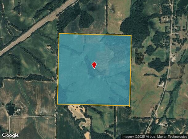
Morton Hill Rd
131-010.00
DISTRICT: 02, COUNTY AREA: H51
Agriculturalland
Haywood
X
Tennessee
47075C0335D
202 AC
2024
Tennessee West Area
2024
Other Market Areas
930500
Brownsville, TN
DEMOGRAPHICS near Morton Hill Rd
1 Mile
3 Mile
5 Mile
2024 Total Population
86
416
1,205
2029 Population
85
408
1,186
Pop Growth 2024-2029
(1.16%)
(1.92%)
(1.58%)
Average Age
46
45
45
2024 Total Households
37
176
509
HH Growth 2024-2029
(2.70%)
(1.70%)
(1.57%)
Median Household Inc
$37,500
$40,937
$39,362
Avg Household Size
2.30
2.40
2.30
2024 Avg HH Vehicles
2.00
2.00
2.00
Median Home Value
$169,999
$162,280
$166,326
Median Year Built
1982
1984
1981
Nearby Places
- Restaurants
- Banks
- Shops
- Fitness
- Groceries
SALE & LEASE HISTORY
LISTING DATE
SALE/LEASE

Sep 25, 2016
For Lease
Sep 24, 2016
For Sale
Nearby Properties
Address
Land Use
TOTAL SIZE
Lot Size
Zoning
Address
Land Use
TOTAL SIZE
Lot Size
Zoning
5,372 SF
3 AC
FAR
Address
Land Use
TOTAL SIZE
Lot Size
Zoning
20,000 SF
9.15 AC
CFH
Address
Land Use
TOTAL SIZE
Lot Size
Zoning
490.70 AC
FAR
Address
Land Use
TOTAL SIZE
Lot Size
Zoning
306 AC
FAR
Address
Land Use
TOTAL SIZE
Lot Size
Zoning
252.83 AC
FH
Address
Land Use
TOTAL SIZE
Lot Size
Zoning
3,844 SF
1 AC
C
Address
Land Use
TOTAL SIZE
Lot Size
Zoning
273.80 AC
FAR
Address
Land Use
TOTAL SIZE
Lot Size
Zoning
432.14 AC
FAR
Address
Land Use
TOTAL SIZE
Lot Size
Zoning
207.50 AC
FAR
Address
Land Use
TOTAL SIZE
Lot Size
Zoning
96.94 AC
FAR
Address
Land Use
TOTAL SIZE
Lot Size
Zoning
451.40 AC
FAR
Address
Land Use
TOTAL SIZE
Lot Size
Zoning
179.80 AC
FAR
Address
Land Use
TOTAL SIZE
Lot Size
Zoning
363.99 AC
FARFH
Address
Land Use
TOTAL SIZE
Lot Size
Zoning
161 AC
FAR
Address
Land Use
TOTAL SIZE
Lot Size
Zoning
147.21 AC
FAR
Address
Land Use
TOTAL SIZE
Lot Size
Zoning
204 AC
FAR
Address
Land Use
TOTAL SIZE
Lot Size
Zoning
146 AC
FAR
Address
Land Use
TOTAL SIZE
Lot Size
Zoning
1,515 SF
144 AC
FAR
Address
Land Use
TOTAL SIZE
Lot Size
Zoning
160 AC
FAR
Address
Land Use
TOTAL SIZE
Lot Size
Zoning
17.40 AC
FAR
Address
Land Use
TOTAL SIZE
Lot Size
Zoning
157.92 AC
FAR
Address
Land Use
TOTAL SIZE
Lot Size
Zoning
104.60 AC
FAR
Address
Land Use
TOTAL SIZE
Lot Size
Zoning
130.50 AC
FAR
Address
Land Use
TOTAL SIZE
Lot Size
Zoning
872 SF
139 AC
FAR
Address
Land Use
TOTAL SIZE
Lot Size
Zoning
60 AC
FAR
Address
Land Use
TOTAL SIZE
Lot Size
Zoning
120.20 AC
Address
Land Use
TOTAL SIZE
Lot Size
Zoning
119.10 AC
FAR
Address
Land Use
TOTAL SIZE
Lot Size
Zoning
100 AC
FAR
Address
Land Use
TOTAL SIZE
Lot Size
Zoning
38 AC
FAR
The World's #1 Commercial Real Estate Marketplace
Connect with us
© 2025 CoStar Group
The information above has been obtained from sources believed reliable. While we do not doubt its accuracy we have not verified it and make no guarantee, warranty or representation about it. It is your responsibility to independently confirm its accuracy and completeness. Any projections, opinions, assumptions, or estimates used are for example only and do not represent the current or future performance of the property. The value of this transaction to you depends on tax and other factors which should be evaluated by your tax, financial, and legal advisors. You and your advisors should conduct a careful, independent investigation of the property to determine to your satisfaction the suitability of the property for your needs.