Property Record
2413 Knights Trail Rd, Nokomis, FL 34275
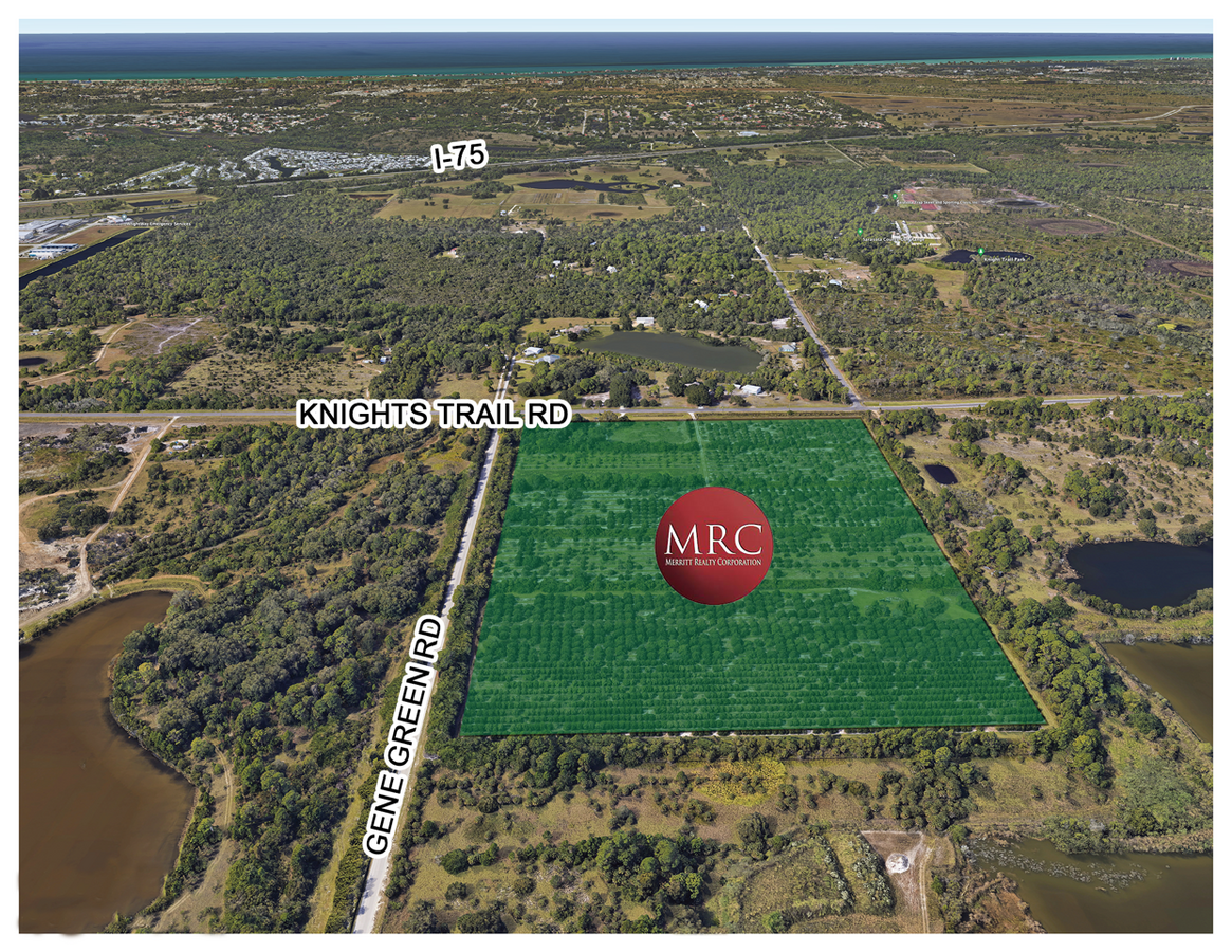
This Property Is For Sale
Land SALE
$25,000,000
59.18 AC Lots
NEARBY LISTINGS FOR SALE OR LEASE
Property Detail
2413 Knights Trail Rd
North Port-Sarasota-Bradenton, FL
Not Part Of A Subdivision
0366-00-3011
THE N 647.45 FT OF S 707.4 FT OF E 336.39 FT OF W 366.39 FT OF NW 1/4 OF SW 1/4 OF SEC 22-38-19, LESS WLY 40 FT FOR KNIGHTS TRAIL RD AS DESC IN OR 2340/472, SUBJ TO 32376 SF UTLITY ESMT TO PEACE
Commercialacreage
Sarasota
X
Florida
12115C0245G
54.33 AC
2023
Sarasota Outlying
2024
Tampa/St Petersburg
002726
DEMOGRAPHICS near 2413 Knights Trail Rd
1 Mile
3 Mile
5 Mile
2024 Total Population
1,419
14,540
54,872
2029 Population
1,718
17,257
64,362
Pop Growth 2024-2029
+ 21.07%
+ 18.69%
+ 17.29%
Average Age
59
59
59
2024 Total Households
698
7,204
27,740
HH Growth 2024-2029
+ 21.20%
+ 18.67%
+ 17.26%
Median Household Inc
$96,323
$87,500
$73,034
Avg Household Size
2.00
2.00
1.90
2024 Avg HH Vehicles
2.00
2.00
2.00
Median Home Value
$450,000
$399,376
$354,487
Median Year Built
2011
2004
1993
Nearby Places
- Restaurants
- Banks
- Shops
- Fitness
- Groceries
PUBLIC TRANSPORTATION
AIRPORT
Sarasota/Bradenton International
DRIVE
WALK
Distance
Sarasota/Bradenton International
39 min
27.9 mi
Punta Gorda
DRIVE
WALK
Distance
Punta Gorda
47 min
37.3 mi
Freight Ports
Port Manatee
DRIVE
WALK
Distance
Port Manatee
52 min
40.4 mi
Nearby Properties
Address
Land Use
TOTAL SIZE
Lot Size
Zoning
Address
Land Use
TOTAL SIZE
Lot Size
Zoning
597,673 SF
65.43 AC
LW
Address
Land Use
TOTAL SIZE
Lot Size
Zoning
263,056 SF
25.54 AC
LW
Address
Land Use
TOTAL SIZE
Lot Size
Zoning
238,850 SF
18.24 AC
LE
Address
Land Use
TOTAL SIZE
Lot Size
Zoning
265,919 SF
28.76 AC
RMF3
Address
Land Use
TOTAL SIZE
Lot Size
Zoning
183,309 SF
56.90 AC
GU
Address
Land Use
TOTAL SIZE
Lot Size
Zoning
177,646 SF
5.23 AC
LE
Address
Land Use
TOTAL SIZE
Lot Size
Zoning
48,681 SF
5 AC
OPI
Address
Land Use
TOTAL SIZE
Lot Size
Zoning
362,000 SF
41.51 AC
PID
Address
Land Use
TOTAL SIZE
Lot Size
Zoning
183,584 SF
14.54 AC
PUD
Address
Land Use
TOTAL SIZE
Lot Size
Zoning
110,209 SF
12.55 AC
PID
Address
Land Use
TOTAL SIZE
Lot Size
Zoning
115,474 SF
12.08 AC
PID
Address
Land Use
TOTAL SIZE
Lot Size
Zoning
51.66 AC
KT
Address
Land Use
TOTAL SIZE
Lot Size
Zoning
70,220 SF
9.31 AC
LW
Address
Land Use
TOTAL SIZE
Lot Size
Zoning
120,200 SF
5.24 AC
PID
Address
Land Use
TOTAL SIZE
Lot Size
Zoning
49,400 SF
4.51 AC
OPI
Address
Land Use
TOTAL SIZE
Lot Size
Zoning
16.44 AC
PUD
Address
Land Use
TOTAL SIZE
Lot Size
Zoning
61,400 SF
3.22 AC
LE
Address
Land Use
TOTAL SIZE
Lot Size
Zoning
14.39 AC
PUD
Address
Land Use
TOTAL SIZE
Lot Size
Zoning
8,105 SF
650.83 AC
GU
Address
Land Use
TOTAL SIZE
Lot Size
Zoning
49,388 SF
3.71 AC
OPI
Address
Land Use
TOTAL SIZE
Lot Size
Zoning
68,029 SF
51.98 AC
GU
Address
Land Use
TOTAL SIZE
Lot Size
Zoning
41.87 AC
PUD
Address
Land Use
TOTAL SIZE
Lot Size
Zoning
13.26 AC
PUD
Address
Land Use
TOTAL SIZE
Lot Size
Zoning
10,804 SF
492.33 AC
GU
Address
Land Use
TOTAL SIZE
Lot Size
Zoning
6,740 SF
648.99 AC
GU
Address
Land Use
TOTAL SIZE
Lot Size
Zoning
18,008 SF
648.77 AC
GU
Address
Land Use
TOTAL SIZE
Lot Size
Zoning
308,834 SF
16 AC
PUD
Address
Land Use
TOTAL SIZE
Lot Size
Zoning
645.20 AC
GU
Address
Land Use
TOTAL SIZE
Lot Size
Zoning
40,987 SF
11.89 AC
OPI
The World's #1 Commercial Real Estate Marketplace
Connect with us
© 2025 CoStar Group
The information above has been obtained from sources believed reliable. While we do not doubt its accuracy we have not verified it and make no guarantee, warranty or representation about it. It is your responsibility to independently confirm its accuracy and completeness. Any projections, opinions, assumptions, or estimates used are for example only and do not represent the current or future performance of the property. The value of this transaction to you depends on tax and other factors which should be evaluated by your tax, financial, and legal advisors. You and your advisors should conduct a careful, independent investigation of the property to determine to your satisfaction the suitability of the property for your needs.