Property Record
0 Northpoint Pkwy, Santa Rosa, CA 95407
Current Lease Availabilities
NEARBY LISTINGS FOR SALE OR LEASE
Property Detail
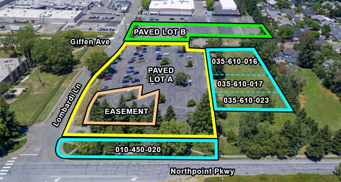
0 Northpoint Pkwy
010-450-019
2020 SPLIT PER LLA19-006
Parkinglot
Sonoma
X
California
06097C0736F
2.86 AC
2023
Santa Rosa
2023
North Bay/Santa Rosa
1533004002
Santa Rosa, CA
DEMOGRAPHICS near 0 Northpoint Pkwy
1 Mile
3 Mile
5 Mile
2024 Total Population
14,090
98,640
189,725
2029 Population
13,867
97,334
187,591
Pop Growth 2024-2029
(1.58%)
(1.32%)
(1.12%)
Average Age
38
38
41
2024 Total Households
4,209
33,492
69,195
HH Growth 2024-2029
(1.59%)
(1.36%)
(1.13%)
Median Household Inc
$88,508
$79,558
$89,641
Avg Household Size
3.20
2.80
2.60
2024 Avg HH Vehicles
2.00
2.00
2.00
Median Home Value
$667,252
$637,522
$709,081
Median Year Built
1993
1981
1979
Nearby Places
- Restaurants
- Banks
- Shops
- Fitness
- Groceries
PUBLIC TRANSPORTATION
COMMUTER RAIL
Santa Rosa Downtown Smart (Main Line - Sonoma Marin Area Rail Transit)
DRIVE
WALK
Distance
Santa Rosa Downtown Smart (Main Line - Sonoma Marin Area Rail Transit)
7 min
3.0 mi
Santa Rosa North Smart (Main Line - Sonoma Marin Area Rail Transit)
DRIVE
WALK
Distance
Santa Rosa North Smart (Main Line - Sonoma Marin Area Rail Transit)
9 min
4.2 mi
AIRPORT
Charles M Schulz - Sonoma County
DRIVE
WALK
Distance
Charles M Schulz - Sonoma County
19 min
11.0 mi
Freight Ports
Port of Richmond
DRIVE
WALK
Distance
Port of Richmond
64 min
48.7 mi
Nearby Properties
Address
Land Use
TOTAL SIZE
Lot Size
Zoning
Address
Land Use
TOTAL SIZE
Lot Size
Zoning
441,698 SF
10.23 AC
C2
Address
Land Use
TOTAL SIZE
Lot Size
Zoning
222,278 SF
13.39 AC
CITYSR
Address
Land Use
TOTAL SIZE
Lot Size
Zoning
447,600 SF
22 AC
Address
Land Use
TOTAL SIZE
Lot Size
Zoning
249,210 SF
22.98 AC
C-2
Address
Land Use
TOTAL SIZE
Lot Size
Zoning
142,297 SF
4.65 AC
Address
Land Use
TOTAL SIZE
Lot Size
Zoning
87,300 SF
6.64 AC
Address
Land Use
TOTAL SIZE
Lot Size
Zoning
87,750 SF
5.43 AC
Address
Land Use
TOTAL SIZE
Lot Size
Zoning
71,800 SF
7.76 AC
CIPD
Address
Land Use
TOTAL SIZE
Lot Size
Zoning
146,611 SF
9.44 AC
Address
Land Use
TOTAL SIZE
Lot Size
Zoning
7,370 SF
4.85 AC
M3
Address
Land Use
TOTAL SIZE
Lot Size
Zoning
82,215 SF
7.91 AC
C2
Address
Land Use
TOTAL SIZE
Lot Size
Zoning
205,776 SF
9.96 AC
CITYSR
Address
Land Use
TOTAL SIZE
Lot Size
Zoning
Address
Land Use
TOTAL SIZE
Lot Size
Zoning
71,739 SF
3.14 AC
Address
Land Use
TOTAL SIZE
Lot Size
Zoning
142,272 SF
11.92 AC
C2
Address
Land Use
TOTAL SIZE
Lot Size
Zoning
49,077 SF
7.09 AC
R210
Address
Land Use
TOTAL SIZE
Lot Size
Zoning
33,698 SF
2.94 AC
CITYSR
Address
Land Use
TOTAL SIZE
Lot Size
Zoning
109,126 SF
3.91 AC
Address
Land Use
TOTAL SIZE
Lot Size
Zoning
Address
Land Use
TOTAL SIZE
Lot Size
Zoning
86,889 SF
6.36 AC
Address
Land Use
TOTAL SIZE
Lot Size
Zoning
152,560 SF
10.92 AC
CITYSR
Address
Land Use
TOTAL SIZE
Lot Size
Zoning
52,764 SF
3.56 AC
Address
Land Use
TOTAL SIZE
Lot Size
Zoning
193,264 SF
11.30 AC
M2
Address
Land Use
TOTAL SIZE
Lot Size
Zoning
85,946 SF
6.10 AC
C2
Address
Land Use
TOTAL SIZE
Lot Size
Zoning
99,362 SF
0.77 AC
CITYSR
Address
Land Use
TOTAL SIZE
Lot Size
Zoning
98,358 SF
8.02 AC
CITYSR
Address
Land Use
TOTAL SIZE
Lot Size
Zoning
160,315 SF
7.24 AC
CITYSR
Address
Land Use
TOTAL SIZE
Lot Size
Zoning
69,327 SF
4.24 AC
Address
Land Use
TOTAL SIZE
Lot Size
Zoning
208,379 SF
9.90 AC
CITYSR
Address
Land Use
TOTAL SIZE
Lot Size
Zoning
233,698 SF
11.64 AC
The World's #1 Commercial Real Estate Marketplace
Connect with us
© 2025 CoStar Group
The information above has been obtained from sources believed reliable. While we do not doubt its accuracy we have not verified it and make no guarantee, warranty or representation about it. It is your responsibility to independently confirm its accuracy and completeness. Any projections, opinions, assumptions, or estimates used are for example only and do not represent the current or future performance of the property. The value of this transaction to you depends on tax and other factors which should be evaluated by your tax, financial, and legal advisors. You and your advisors should conduct a careful, independent investigation of the property to determine to your satisfaction the suitability of the property for your needs.