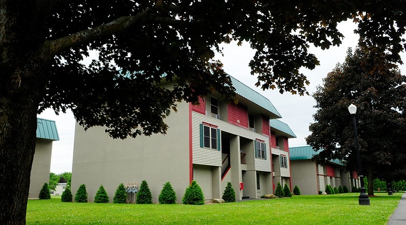
Property Record
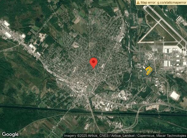
Park Dr, Rome, NY 13440
NEARBY LISTINGS FOR SALE OR LEASE
Property Detail
Park Dr
301301 243.006-0002-032
APTS & LAND-11.245A
Apartment
Oneida
X
New York
36065C0558F
32.000
2022
11.24 AC
2023
Rome
026300
Utica/Rome
10,836 SF
Utica-Rome, NY
DEMOGRAPHICS near Park Dr
1 Mile
3 Mile
5 Mile
2024 Total Population
5,022
27,921
35,735
2029 Population
5,084
27,648
35,374
Pop Growth 2024-2029
+ 1.23%
(0.98%)
(1.01%)
Average Age
37
41
41
2024 Total Households
2,233
12,227
14,987
HH Growth 2024-2029
+ 0.58%
(1.15%)
(1.19%)
Median Household Inc
$46,077
$49,849
$55,817
Avg Household Size
2.10
2.20
2.20
2024 Avg HH Vehicles
1.00
1.00
2.00
Median Home Value
$78,970
$112,986
$131,005
Median Year Built
1961
1953
1955
Nearby Places
- Restaurants
- Banks
- Shops
- Fitness
- Groceries
PUBLIC TRANSPORTATION
COMMUTER RAIL
Rome (Toronto - New York - VIA Rail)
DRIVE
WALK
Distance
Rome (Toronto - New York - VIA Rail)
3 min
1.7 mi
Rome Amtrak Station (Empire Service - Amtrak, Maple Leaf - Amtrak)
DRIVE
WALK
Distance
Rome Amtrak Station (Empire Service - Amtrak, Maple Leaf - Amtrak)
3 min
1.7 mi
Freight Ports
Albany, NY Port
DRIVE
WALK
Distance
Albany, NY Port
131 min
109.3 mi
Nearby Properties
Address
Land Use
TOTAL SIZE
Lot Size
Zoning
Address
Land Use
TOTAL SIZE
Lot Size
Zoning
16,970 SF
1,263.52 AC
GB
Address
Land Use
TOTAL SIZE
Lot Size
Zoning
273,250 SF
78.37 AC
GB
Address
Land Use
TOTAL SIZE
Lot Size
Zoning
213,891 SF
7.70 AC
I
Address
Land Use
TOTAL SIZE
Lot Size
Zoning
70,000 SF
126.93 AC
GB
Address
Land Use
TOTAL SIZE
Lot Size
Zoning
777,552 SF
63.78 AC
GB
Address
Land Use
TOTAL SIZE
Lot Size
Zoning
25,110 SF
51.76 AC
AG
Address
Land Use
TOTAL SIZE
Lot Size
Zoning
11,842 SF
18.34 AC
GB
Address
Land Use
TOTAL SIZE
Lot Size
Zoning
78,658 SF
1.92 AC
AG
Address
Land Use
TOTAL SIZE
Lot Size
Zoning
385,216 SF
30.87 AC
GB
Address
Land Use
TOTAL SIZE
Lot Size
Zoning
10.50 AC
NA
Address
Land Use
TOTAL SIZE
Lot Size
Zoning
195,839 SF
22.69 AC
GB
Address
Land Use
TOTAL SIZE
Lot Size
Zoning
77,604 SF
4.34 AC
GB
Address
Land Use
TOTAL SIZE
Lot Size
Zoning
80 AC
GB
Address
Land Use
TOTAL SIZE
Lot Size
Zoning
206,841 SF
22.90 AC
C-2
Address
Land Use
TOTAL SIZE
Lot Size
Zoning
58,560 SF
2.44 AC
R-P
Address
Land Use
TOTAL SIZE
Lot Size
Zoning
112,259 SF
2.59 AC
C-3
Address
Land Use
TOTAL SIZE
Lot Size
Zoning
6,104 SF
123.23 AC
GB
Address
Land Use
TOTAL SIZE
Lot Size
Zoning
131,001 SF
14.70 AC
R-2
Address
Land Use
TOTAL SIZE
Lot Size
Zoning
173,579 SF
14.46 AC
R-1-8
Address
Land Use
TOTAL SIZE
Lot Size
Zoning
75,547 SF
12.17 AC
GB
Address
Land Use
TOTAL SIZE
Lot Size
Zoning
33,956 SF
387.82 AC
AG
Address
Land Use
TOTAL SIZE
Lot Size
Zoning
41,262 SF
16.30 AC
R-1-8
Address
Land Use
TOTAL SIZE
Lot Size
Zoning
113,024 SF
10.39 AC
GB
Address
Land Use
TOTAL SIZE
Lot Size
Zoning
8,430 SF
60.20 AC
Address
Land Use
TOTAL SIZE
Lot Size
Zoning
133,723 SF
9.28 AC
C-2
Address
Land Use
TOTAL SIZE
Lot Size
Zoning
25,002 SF
6.53 AC
R-3
Address
Land Use
TOTAL SIZE
Lot Size
Zoning
49,643 SF
8 AC
C-1
Address
Land Use
TOTAL SIZE
Lot Size
Zoning
2,630 SF
13.09 AC
R-3
Address
Land Use
TOTAL SIZE
Lot Size
Zoning
3,778 SF
15.52 AC
OS
The World's #1 Commercial Real Estate Marketplace
Connect with us
© 2025 CoStar Group
The information above has been obtained from sources believed reliable. While we do not doubt its accuracy we have not verified it and make no guarantee, warranty or representation about it. It is your responsibility to independently confirm its accuracy and completeness. Any projections, opinions, assumptions, or estimates used are for example only and do not represent the current or future performance of the property. The value of this transaction to you depends on tax and other factors which should be evaluated by your tax, financial, and legal advisors. You and your advisors should conduct a careful, independent investigation of the property to determine to your satisfaction the suitability of the property for your needs.