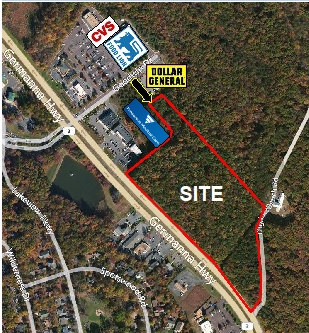
Property Record
Partnership Way, Locust Grove, VA 22508
NEARBY LISTINGS FOR SALE OR LEASE
-
-
View all Locust Grove listings for sale on LoopNet.com
Property Detail
Partnership Way
013-00-00-00-0016-0
13-16 WILDERNESS DB#180001374 PC 8/167/168
Agriculturalland
Orange
X
Virginia
51137C0205E
16
2024
39.76 AC
2024
Virginia Regional
110107
Other Market Areas
DEMOGRAPHICS near Partnership Way
1 Mile
3 Mile
5 Mile
2024 Total Population
2,509
15,358
22,590
2029 Population
2,879
17,575
25,661
Pop Growth 2024-2029
+ 14.75%
+ 14.44%
+ 13.59%
Average Age
48
43
42
2024 Total Households
1,071
5,899
8,355
HH Growth 2024-2029
+ 14.85%
+ 14.60%
+ 13.81%
Median Household Inc
$94,174
$108,544
$111,401
Avg Household Size
2.30
2.60
2.70
2024 Avg HH Vehicles
2.00
2.00
2.00
Median Home Value
$318,412
$329,918
$341,174
Median Year Built
1993
2001
2001
Nearby Places
- Restaurants
- Banks
- Shops
- Fitness
- Groceries
SALE & LEASE HISTORY
LISTING DATE
SALE/LEASE

Sep 24, 2016
For Sale
Nearby Properties
Address
Land Use
TOTAL SIZE
Lot Size
Zoning
Address
Land Use
TOTAL SIZE
Lot Size
Zoning
182,737 SF
158.76 AC
A AGRICULT
Address
Land Use
TOTAL SIZE
Lot Size
Zoning
72,642 SF
9.10 AC
A AGRICULT
Address
Land Use
TOTAL SIZE
Lot Size
Zoning
37,019 SF
2.03 AC
R3 PLANNED
Address
Land Use
TOTAL SIZE
Lot Size
Zoning
62,364 SF
7.09 AC
C2 GENERAL
Address
Land Use
TOTAL SIZE
Lot Size
Zoning
853.89 AC
PDM MIXED
Address
Land Use
TOTAL SIZE
Lot Size
Zoning
60,873 SF
1.94 AC
C2 GENERAL
Address
Land Use
TOTAL SIZE
Lot Size
Zoning
3,678 SF
338 AC
A3 - AGRIC
Address
Land Use
TOTAL SIZE
Lot Size
Zoning
906.45 AC
PDM MIXED
Address
Land Use
TOTAL SIZE
Lot Size
Zoning
10,508 SF
2.19 AC
R3 PLANNED
Address
Land Use
TOTAL SIZE
Lot Size
Zoning
13,200 SF
7.16 AC
C2 GENERAL
Address
Land Use
TOTAL SIZE
Lot Size
Zoning
2,688 SF
350 AC
RU - RURAL
Address
Land Use
TOTAL SIZE
Lot Size
Zoning
4,401 SF
1.58 AC
C2 GENERAL
Address
Land Use
TOTAL SIZE
Lot Size
Zoning
9,480 SF
1.20 AC
C2 GENERAL
Address
Land Use
TOTAL SIZE
Lot Size
Zoning
630.08 AC
A AGRICULT
Address
Land Use
TOTAL SIZE
Lot Size
Zoning
13,897 SF
1.83 AC
C2 GENERAL
Address
Land Use
TOTAL SIZE
Lot Size
Zoning
251 AC
A3 - AGRIC
Address
Land Use
TOTAL SIZE
Lot Size
Zoning
22,100 SF
2.54 AC
C2 GENERAL
Address
Land Use
TOTAL SIZE
Lot Size
Zoning
22,400 SF
2.55 AC
C2 GENERAL
Address
Land Use
TOTAL SIZE
Lot Size
Zoning
48.58 AC
C2 GENERAL
Address
Land Use
TOTAL SIZE
Lot Size
Zoning
91.23 AC
C2 GENERAL
Address
Land Use
TOTAL SIZE
Lot Size
Zoning
7,296 SF
3 AC
A AGRICULT
Address
Land Use
TOTAL SIZE
Lot Size
Zoning
147.32 AC
R3 PLANNED
Address
Land Use
TOTAL SIZE
Lot Size
Zoning
117.39 AC
PDM MIXED
Address
Land Use
TOTAL SIZE
Lot Size
Zoning
6,768 SF
1 AC
C2 GENERAL
Address
Land Use
TOTAL SIZE
Lot Size
Zoning
207.13 AC
A AGRICULT
Address
Land Use
TOTAL SIZE
Lot Size
Zoning
20,600 SF
2.54 AC
C2 GENERAL
Address
Land Use
TOTAL SIZE
Lot Size
Zoning
3,724 SF
1.08 AC
C2 GENERAL
Address
Land Use
TOTAL SIZE
Lot Size
Zoning
193.50 AC
PDM MIXED
Address
Land Use
TOTAL SIZE
Lot Size
Zoning
5,768 SF
1.60 AC
C2 GENERAL
The World's #1 Commercial Real Estate Marketplace
Connect with us
© 2025 CoStar Group
The information above has been obtained from sources believed reliable. While we do not doubt its accuracy we have not verified it and make no guarantee, warranty or representation about it. It is your responsibility to independently confirm its accuracy and completeness. Any projections, opinions, assumptions, or estimates used are for example only and do not represent the current or future performance of the property. The value of this transaction to you depends on tax and other factors which should be evaluated by your tax, financial, and legal advisors. You and your advisors should conduct a careful, independent investigation of the property to determine to your satisfaction the suitability of the property for your needs.