Property Record
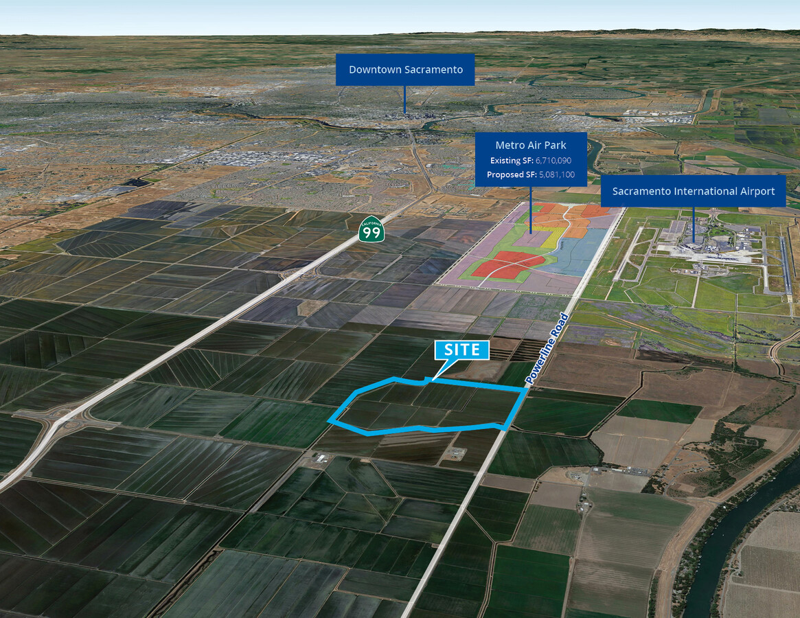
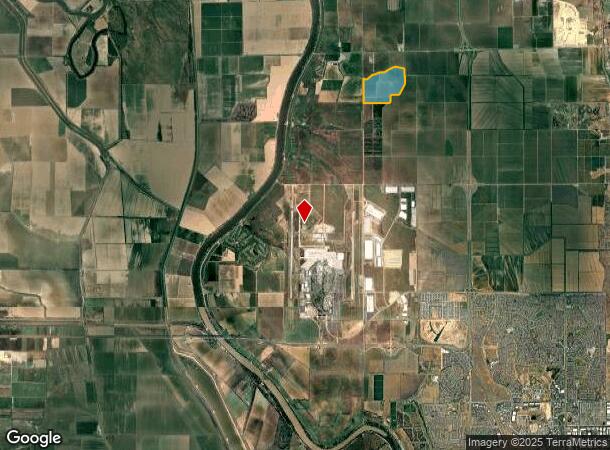
Powerline Rd, Sacramento, CA 95837
This Property Is For Sale
NEARBY LISTINGS FOR SALE OR LEASE
Property Detail
Powerline Rd
Yuba City, CA
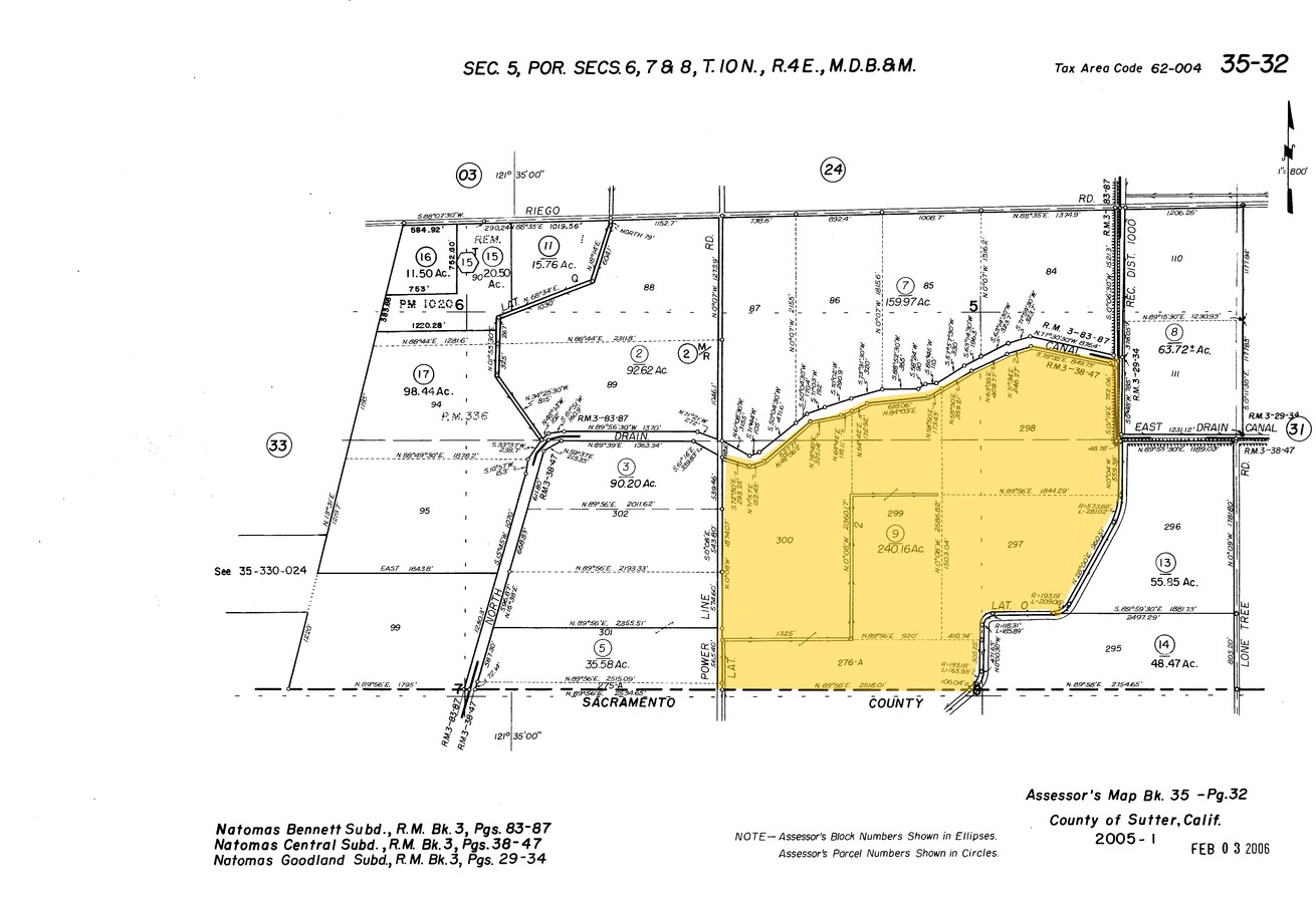
Natomas Central
35-320-009
NATOMAS CENTRAL SUBD LOTS 276A,297,298,299,300, AS SHOWN ON SUBD MAP RECORDED IN BOOK 3 OF SURVEYS, PG 38. (FROM RECORED DOCUMENT/SJ)
Orchard
Sutter
A99
California
0603940855F
276a
2023
240.16 AC
2023
Sutter County
007101
Sacramento
DEMOGRAPHICS near Powerline Rd
1 Mile
3 Mile
5 Mile
2024 Total Population
6
112
9,313
2029 Population
5
106
9,566
Pop Growth 2024-2029
(16.67%)
(5.36%)
+ 2.72%
Average Age
0
43
40
2024 Total Households
2
41
3,118
HH Growth 2024-2029
0.00%
(4.88%)
+ 2.53%
Median Household Inc
$0
$55,000
$121,989
Avg Household Size
2.00
2.80
3.00
2024 Avg HH Vehicles
2.00
2.00
2.00
Median Home Value
$750,000
$711,538
$607,546
Median Year Built
1974
1968
2005
Nearby Places
- Restaurants
- Banks
- Shops
- Fitness
- Groceries
PUBLIC TRANSPORTATION
AIRPORT
Sacramento International
DRIVE
WALK
Distance
Sacramento International
15 min
7.4 mi
Freight Ports
Port of Stockton
DRIVE
WALK
Distance
Port of Stockton
70 min
59.1 mi
Nearby Properties
Address
Land Use
TOTAL SIZE
Lot Size
Zoning
Address
Land Use
TOTAL SIZE
Lot Size
Zoning
85.45 AC
SPA
Address
Land Use
TOTAL SIZE
Lot Size
Zoning
1,134,362 SF
132.79 AC
SPA
Address
Land Use
TOTAL SIZE
Lot Size
Zoning
805,506 SF
68.27 AC
SPA
Address
Land Use
TOTAL SIZE
Lot Size
Zoning
Address
Land Use
TOTAL SIZE
Lot Size
Zoning
30.05 AC
SPA
Address
Land Use
TOTAL SIZE
Lot Size
Zoning
30.39 AC
SPA
Address
Land Use
TOTAL SIZE
Lot Size
Zoning
30.44 AC
SPA
Address
Land Use
TOTAL SIZE
Lot Size
Zoning
31.76 AC
SPA
Address
Land Use
TOTAL SIZE
Lot Size
Zoning
17.55 AC
SPA
Address
Land Use
TOTAL SIZE
Lot Size
Zoning
19.68 AC
SPA
Address
Land Use
TOTAL SIZE
Lot Size
Zoning
Address
Land Use
TOTAL SIZE
Lot Size
Zoning
131.26 AC
SPA
Address
Land Use
TOTAL SIZE
Lot Size
Zoning
Address
Land Use
TOTAL SIZE
Lot Size
Zoning
12.99 AC
SPA
Address
Land Use
TOTAL SIZE
Lot Size
Zoning
Address
Land Use
TOTAL SIZE
Lot Size
Zoning
Address
Land Use
TOTAL SIZE
Lot Size
Zoning
Address
Land Use
TOTAL SIZE
Lot Size
Zoning
27.47 AC
SPA
Address
Land Use
TOTAL SIZE
Lot Size
Zoning
Address
Land Use
TOTAL SIZE
Lot Size
Zoning
8.84 AC
SPA
Address
Land Use
TOTAL SIZE
Lot Size
Zoning
Address
Land Use
TOTAL SIZE
Lot Size
Zoning
61.06 AC
SPA
Address
Land Use
TOTAL SIZE
Lot Size
Zoning
Address
Land Use
TOTAL SIZE
Lot Size
Zoning
25 AC
SPA
Address
Land Use
TOTAL SIZE
Lot Size
Zoning
Address
Land Use
TOTAL SIZE
Lot Size
Zoning
Address
Land Use
TOTAL SIZE
Lot Size
Zoning
Address
Land Use
TOTAL SIZE
Lot Size
Zoning
22.06 AC
SPA
Address
Land Use
TOTAL SIZE
Lot Size
Zoning
Address
Land Use
TOTAL SIZE
Lot Size
Zoning
287.71 AC
AG-80
The World's #1 Commercial Real Estate Marketplace
Connect with us
© 2025 CoStar Group
The information above has been obtained from sources believed reliable. While we do not doubt its accuracy we have not verified it and make no guarantee, warranty or representation about it. It is your responsibility to independently confirm its accuracy and completeness. Any projections, opinions, assumptions, or estimates used are for example only and do not represent the current or future performance of the property. The value of this transaction to you depends on tax and other factors which should be evaluated by your tax, financial, and legal advisors. You and your advisors should conduct a careful, independent investigation of the property to determine to your satisfaction the suitability of the property for your needs.