Property Record
3151 Presidential Golf Dr, Upper Marlboro, MD 20774
This Property Is For Sale
NEARBY LISTINGS FOR SALE OR LEASE
Property Detail
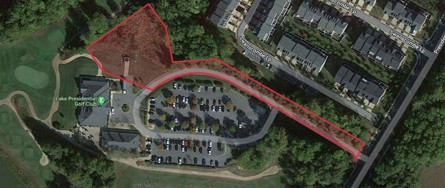
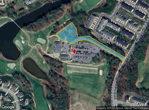
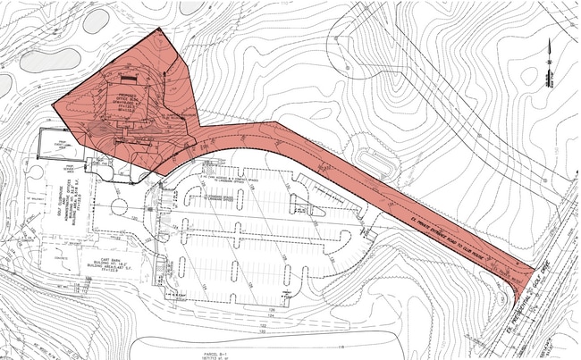
3151 Presidential Golf Dr
03-3323003
PLAT 19 PARCEL B10
Commercialnec
Prince George's
X
Maryland
24033C0280E
1.69 AC
2023
Greater Upper Marlboro
2025
Washington, DC
800608
Washington-Arlington-Alexandria, DC-VA-MD-WV
DEMOGRAPHICS near 3151 Presidential Golf Dr
1 Mile
3 Mile
5 Mile
2024 Total Population
6,249
27,728
62,293
2029 Population
6,069
27,096
61,077
Pop Growth 2024-2029
(2.88%)
(2.28%)
(1.95%)
Average Age
39
41
42
2024 Total Households
2,121
10,029
22,437
HH Growth 2024-2029
(3.02%)
(2.34%)
(2.05%)
Median Household Inc
$167,015
$130,470
$129,480
Avg Household Size
2.90
2.70
2.70
2024 Avg HH Vehicles
2.00
2.00
2.00
Median Home Value
$532,640
$422,312
$438,050
Median Year Built
2010
1995
1994
Nearby Places
Map Layers
Map Styles
 Street
 Aerial
- Restaurants
- Banks
- Shops
- Fitness
- Groceries
PUBLIC TRANSPORTATION
AIRPORT
Ronald Reagan Washington Ntl
DRIVE
WALK
Distance
Ronald Reagan Washington Ntl
43 min
24.1 mi
Baltimore/Washington International Thurgood Marshall
DRIVE
WALK
Distance
Baltimore/Washington International Thurgood Marshall
46 min
29.6 mi
Freight Ports
Port of Baltimore
DRIVE
WALK
Distance
Port of Baltimore
54 min
35.1 mi
Nearby Properties
Address
Land Use
TOTAL SIZE
Lot Size
Zoning
Address
Land Use
TOTAL SIZE
Lot Size
Zoning
643,009 SF
2.15 AC
CGO
Address
Land Use
TOTAL SIZE
Lot Size
Zoning
1,251,903 SF
157.53 AC
IH
Address
Land Use
TOTAL SIZE
Lot Size
Zoning
28.85 AC
RR
Address
Land Use
TOTAL SIZE
Lot Size
Zoning
6.65 AC
LCD
Address
Land Use
TOTAL SIZE
Lot Size
Zoning
135,099 SF
147.75 AC
AR
Address
Land Use
TOTAL SIZE
Lot Size
Zoning
306,916 SF
26.65 AC
IH
Address
Land Use
TOTAL SIZE
Lot Size
Zoning
147,395 SF
8.28 AC
LCD
Address
Land Use
TOTAL SIZE
Lot Size
Zoning
290,919 SF
28.01 AC
IH
Address
Land Use
TOTAL SIZE
Lot Size
Zoning
170,850 SF
28.43 AC
IH
Address
Land Use
TOTAL SIZE
Lot Size
Zoning
378,068 SF
24.35 AC
IH
Address
Land Use
TOTAL SIZE
Lot Size
Zoning
392,581 SF
27.85 AC
IH
Address
Land Use
TOTAL SIZE
Lot Size
Zoning
222,152 SF
11.89 AC
IH
Address
Land Use
TOTAL SIZE
Lot Size
Zoning
242,331 SF
19.71 AC
IH
Address
Land Use
TOTAL SIZE
Lot Size
Zoning
188,751 SF
9.81 AC
IH
Address
Land Use
TOTAL SIZE
Lot Size
Zoning
117,395 SF
12.84 AC
IE
Address
Land Use
TOTAL SIZE
Lot Size
Zoning
2,538 SF
36.50 AC
C3
Address
Land Use
TOTAL SIZE
Lot Size
Zoning
169,840 SF
9.81 AC
IH
Address
Land Use
TOTAL SIZE
Lot Size
Zoning
113,997 SF
15.72 AC
IE
Address
Land Use
TOTAL SIZE
Lot Size
Zoning
88,689 SF
12.71 AC
LCD
Address
Land Use
TOTAL SIZE
Lot Size
Zoning
103,679 SF
7.44 AC
IH
Address
Land Use
TOTAL SIZE
Lot Size
Zoning
85,255 SF
7.15 AC
IH
Address
Land Use
TOTAL SIZE
Lot Size
Zoning
68,096 SF
10.54 AC
CGO
Address
Land Use
TOTAL SIZE
Lot Size
Zoning
5.01 AC
LCD
Address
Land Use
TOTAL SIZE
Lot Size
Zoning
109,507 SF
10.21 AC
RSF95
Address
Land Use
TOTAL SIZE
Lot Size
Zoning
110,000 SF
6.88 AC
IH
Address
Land Use
TOTAL SIZE
Lot Size
Zoning
284,580 SF
4.77 AC
CGO
Address
Land Use
TOTAL SIZE
Lot Size
Zoning
138,790 SF
13.16 AC
IH
Address
Land Use
TOTAL SIZE
Lot Size
Zoning
62,250 SF
8.36 AC
IE
Address
Land Use
TOTAL SIZE
Lot Size
Zoning
41,081 SF
3.83 AC
RR
Address
Land Use
TOTAL SIZE
Lot Size
Zoning
149,336 SF
29.82 AC
IH
The World's #1 Commercial Real Estate Marketplace
Connect with us
© 2026 CoStar Group
The information above has been obtained from sources believed reliable. While we do not doubt its accuracy we have not verified it and make no guarantee, warranty or representation about it. It is your responsibility to independently confirm its accuracy and completeness. Any projections, opinions, assumptions, or estimates used are for example only and do not represent the current or future performance of the property. The value of this transaction to you depends on tax and other factors which should be evaluated by your tax, financial, and legal advisors. You and your advisors should conduct a careful, independent investigation of the property to determine to your satisfaction the suitability of the property for your needs.