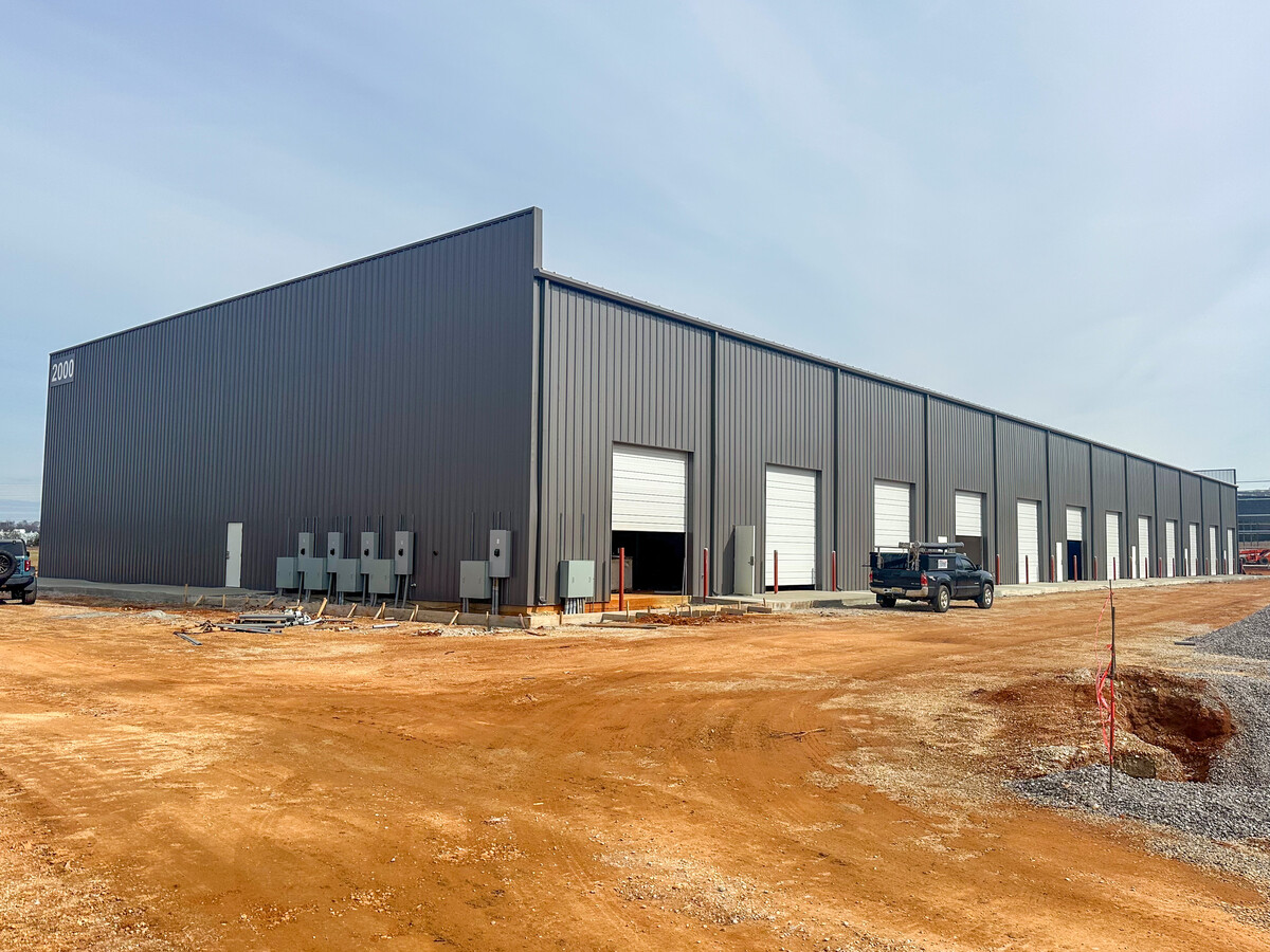
Property Record
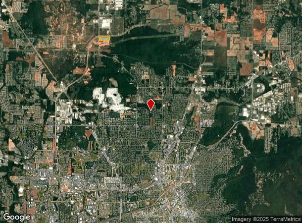
Pulaski Pike Nw, Huntsville, AL 35810
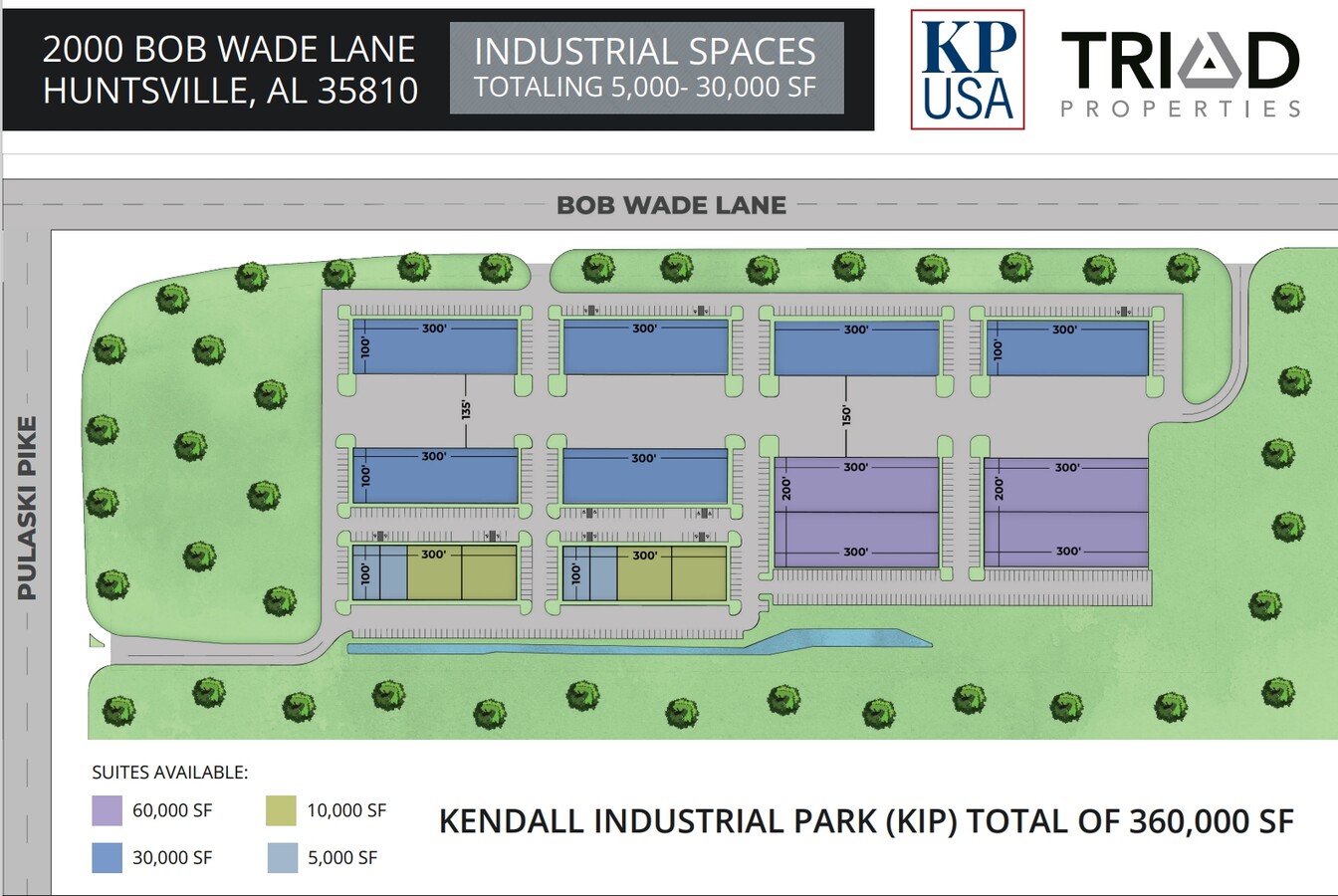
Current Lease Availabilities
NEARBY LISTINGS FOR SALE OR LEASE
Property Detail
Pulaski Pike Nw
Huntsville, AL
Lanier Subdivision
07-08-33-0-000-005.000
LOT 1 LANIER SUBDIVISION PB # 20050429000271510
Commercialacreage
Madison
X
Alabama
01089C0159E
1
2024
33 AC
2024
North Huntsville
000302
Huntsville
DEMOGRAPHICS near Pulaski Pike Nw
1 Mile
3 Mile
5 Mile
2024 Total Population
108
8,171
64,472
2029 Population
119
9,098
70,647
Pop Growth 2024-2029
+ 10.19%
+ 11.35%
+ 9.58%
Average Age
41
41
39
2024 Total Households
41
3,209
23,885
HH Growth 2024-2029
+ 12.20%
+ 11.81%
+ 10.43%
Median Household Inc
$66,250
$62,826
$68,425
Avg Household Size
2.60
2.50
2.50
2024 Avg HH Vehicles
2.00
2.00
2.00
Median Home Value
$207,143
$193,798
$195,735
Median Year Built
1982
1987
1987
Nearby Places
- Restaurants
- Banks
- Shops
- Fitness
- Groceries
PUBLIC TRANSPORTATION
AIRPORT
Huntsville International-Carl T Jones Field
DRIVE
WALK
Distance
Huntsville International-Carl T Jones Field
27 min
18.0 mi
Freight Ports
Port of Mobile
DRIVE
WALK
Distance
Port of Mobile
395 min
359.2 mi
Nearby Properties
Address
Land Use
TOTAL SIZE
Lot Size
Zoning
Address
Land Use
TOTAL SIZE
Lot Size
Zoning
Address
Land Use
TOTAL SIZE
Lot Size
Zoning
Address
Land Use
TOTAL SIZE
Lot Size
Zoning
Address
Land Use
TOTAL SIZE
Lot Size
Zoning
119,994 SF
14.93 AC
Address
Land Use
TOTAL SIZE
Lot Size
Zoning
Address
Land Use
TOTAL SIZE
Lot Size
Zoning
155,868 SF
2.07 AC
Address
Land Use
TOTAL SIZE
Lot Size
Zoning
90,690 SF
9.29 AC
Address
Land Use
TOTAL SIZE
Lot Size
Zoning
12,240 SF
10 AC
Address
Land Use
TOTAL SIZE
Lot Size
Zoning
61,096 SF
47 AC
Address
Land Use
TOTAL SIZE
Lot Size
Zoning
204,388 SF
24.81 AC
Address
Land Use
TOTAL SIZE
Lot Size
Zoning
34,808 SF
4.51 AC
Address
Land Use
TOTAL SIZE
Lot Size
Zoning
147,948 SF
14.83 AC
Address
Land Use
TOTAL SIZE
Lot Size
Zoning
100,000 SF
8.67 AC
Address
Land Use
TOTAL SIZE
Lot Size
Zoning
12,904 SF
10.01 AC
Address
Land Use
TOTAL SIZE
Lot Size
Zoning
56,565 SF
3.99 AC
Address
Land Use
TOTAL SIZE
Lot Size
Zoning
139,251 SF
20.35 AC
Address
Land Use
TOTAL SIZE
Lot Size
Zoning
30,513 SF
16 AC
Address
Land Use
TOTAL SIZE
Lot Size
Zoning
5,126 SF
15 AC
Address
Land Use
TOTAL SIZE
Lot Size
Zoning
43,018 SF
7.57 AC
Address
Land Use
TOTAL SIZE
Lot Size
Zoning
107,500 SF
13.30 AC
Address
Land Use
TOTAL SIZE
Lot Size
Zoning
6,048 SF
11 AC
Address
Land Use
TOTAL SIZE
Lot Size
Zoning
56,246 SF
9 AC
Address
Land Use
TOTAL SIZE
Lot Size
Zoning
15,806 SF
13.76 AC
Address
Land Use
TOTAL SIZE
Lot Size
Zoning
48,912 SF
2.04 AC
Address
Land Use
TOTAL SIZE
Lot Size
Zoning
104,000 SF
15.86 AC
Address
Land Use
TOTAL SIZE
Lot Size
Zoning
19,824 SF
4.29 AC
Address
Land Use
TOTAL SIZE
Lot Size
Zoning
6,212 SF
5.97 AC
Address
Land Use
TOTAL SIZE
Lot Size
Zoning
5,625 SF
5.81 AC
Address
Land Use
TOTAL SIZE
Lot Size
Zoning
388 SF
7.18 AC
The World's #1 Commercial Real Estate Marketplace
Connect with us
© 2025 CoStar Group
The information above has been obtained from sources believed reliable. While we do not doubt its accuracy we have not verified it and make no guarantee, warranty or representation about it. It is your responsibility to independently confirm its accuracy and completeness. Any projections, opinions, assumptions, or estimates used are for example only and do not represent the current or future performance of the property. The value of this transaction to you depends on tax and other factors which should be evaluated by your tax, financial, and legal advisors. You and your advisors should conduct a careful, independent investigation of the property to determine to your satisfaction the suitability of the property for your needs.