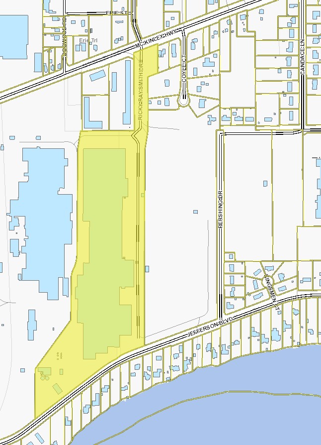
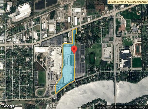
Property Record
Ricky Ray Smith Dr, Mishawaka, IN 46545
NEARBY LISTINGS FOR SALE OR LEASE
Property Detail
Ricky Ray Smith Dr
South Bend-Mishawaka, IN-MI
Am General Mishawaka Minor Sub
71-10-07-101-001.000-031
LOT 1 AM GENERAL MISHAWAKA MINOR SUB SEC 7-T37N-R4E 18/19 18/19 NP 2560 9/15/17 01-02 VAC ORD #156-2000
Lightindustrial
St Joseph
X
Indiana
18141C0236E
1
2022
32.18 AC
2023
Outlying St Joseph County
011506
South Bend/Mishawaka
653,141 SF
DEMOGRAPHICS near Ricky Ray Smith Dr
1 Mile
3 Mile
5 Mile
2024 Total Population
3,081
31,082
103,313
2029 Population
3,047
30,665
102,538
Pop Growth 2024-2029
(1.10%)
(1.34%)
(0.75%)
Average Age
42
40
39
2024 Total Households
1,222
12,235
42,906
HH Growth 2024-2029
(1.15%)
(1.40%)
(0.71%)
Median Household Inc
$83,099
$70,835
$60,243
Avg Household Size
2.50
2.50
2.30
2024 Avg HH Vehicles
2.00
2.00
2.00
Median Home Value
$215,457
$170,700
$164,783
Median Year Built
1975
1972
1973
Nearby Places
- Restaurants
- Banks
- Shops
- Fitness
- Groceries
PUBLIC TRANSPORTATION
COMMUTER RAIL
Elkhart Amtrak Station (Capitol Limited - Amtrak, Lake Shore Limited - Amtrak)
DRIVE
WALK
Distance
Elkhart Amtrak Station (Capitol Limited - Amtrak, Lake Shore Limited - Amtrak)
14 min
8.2 mi
South Bend Amtrak Station (Capitol Limited - Amtrak, Lake Shore Limited - Amtrak)
DRIVE
WALK
Distance
South Bend Amtrak Station (Capitol Limited - Amtrak, Lake Shore Limited - Amtrak)
19 min
9.3 mi
AIRPORT
South Bend International
DRIVE
WALK
Distance
South Bend International
31 min
13.3 mi
Freight Ports
Port Milwaukee
DRIVE
WALK
Distance
Port Milwaukee
226 min
188.8 mi
Nearby Properties
Address
Land Use
TOTAL SIZE
Lot Size
Zoning
Address
Land Use
TOTAL SIZE
Lot Size
Zoning
36,851 SF
22.72 AC
Address
Land Use
TOTAL SIZE
Lot Size
Zoning
623,232 SF
74.18 AC
Address
Land Use
TOTAL SIZE
Lot Size
Zoning
149,821 SF
11.73 AC
Address
Land Use
TOTAL SIZE
Lot Size
Zoning
389,851 SF
23.89 AC
Address
Land Use
TOTAL SIZE
Lot Size
Zoning
270,962 SF
27.20 AC
Address
Land Use
TOTAL SIZE
Lot Size
Zoning
120,513 SF
7.92 AC
Address
Land Use
TOTAL SIZE
Lot Size
Zoning
105,917 SF
5.90 AC
Address
Land Use
TOTAL SIZE
Lot Size
Zoning
261,621 SF
23.42 AC
Address
Land Use
TOTAL SIZE
Lot Size
Zoning
35,066 SF
3.16 AC
Address
Land Use
TOTAL SIZE
Lot Size
Zoning
198,582 SF
10.37 AC
Address
Land Use
TOTAL SIZE
Lot Size
Zoning
152,542 SF
9.45 AC
Address
Land Use
TOTAL SIZE
Lot Size
Zoning
295,683 SF
21.32 AC
Address
Land Use
TOTAL SIZE
Lot Size
Zoning
226,496 SF
25.73 AC
Address
Land Use
TOTAL SIZE
Lot Size
Zoning
57,293 SF
15 AC
Address
Land Use
TOTAL SIZE
Lot Size
Zoning
34,304 SF
4.50 AC
Address
Land Use
TOTAL SIZE
Lot Size
Zoning
47,240 SF
6.66 AC
Address
Land Use
TOTAL SIZE
Lot Size
Zoning
42,500 SF
1.93 AC
Address
Land Use
TOTAL SIZE
Lot Size
Zoning
12.50 AC
Address
Land Use
TOTAL SIZE
Lot Size
Zoning
146,084 SF
10.73 AC
Address
Land Use
TOTAL SIZE
Lot Size
Zoning
8,400 SF
106 AC
Address
Land Use
TOTAL SIZE
Lot Size
Zoning
24,510 SF
2.20 AC
Address
Land Use
TOTAL SIZE
Lot Size
Zoning
37,656 SF
1.70 AC
Address
Land Use
TOTAL SIZE
Lot Size
Zoning
30,344 SF
7.94 AC
Address
Land Use
TOTAL SIZE
Lot Size
Zoning
22,924 SF
8.32 AC
Address
Land Use
TOTAL SIZE
Lot Size
Zoning
41,680 SF
3.62 AC
Address
Land Use
TOTAL SIZE
Lot Size
Zoning
61,384 SF
5.62 AC
Address
Land Use
TOTAL SIZE
Lot Size
Zoning
75,000 SF
5.10 AC
Address
Land Use
TOTAL SIZE
Lot Size
Zoning
50,736 SF
4.77 AC
Address
Land Use
TOTAL SIZE
Lot Size
Zoning
32,756 SF
4.93 AC
The World's #1 Commercial Real Estate Marketplace
Connect with us
© 2025 CoStar Group
The information above has been obtained from sources believed reliable. While we do not doubt its accuracy we have not verified it and make no guarantee, warranty or representation about it. It is your responsibility to independently confirm its accuracy and completeness. Any projections, opinions, assumptions, or estimates used are for example only and do not represent the current or future performance of the property. The value of this transaction to you depends on tax and other factors which should be evaluated by your tax, financial, and legal advisors. You and your advisors should conduct a careful, independent investigation of the property to determine to your satisfaction the suitability of the property for your needs.