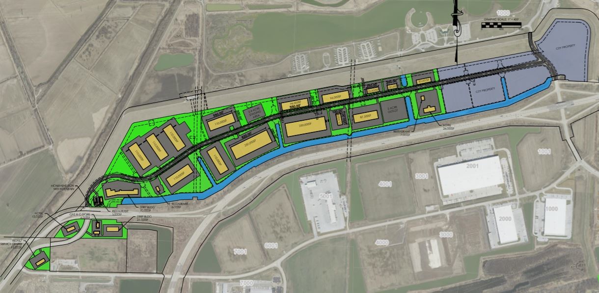
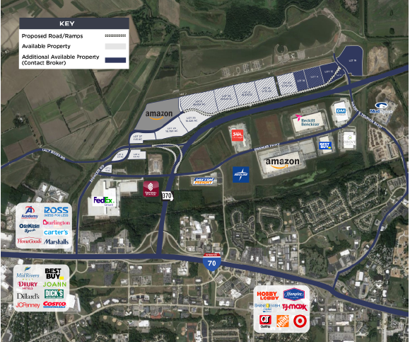
Property Record
Spencer Rd, St Peters, MO 63376
NEARBY LISTINGS FOR SALE OR LEASE
Property Detail
Spencer Rd
St. Louis, MO-IL
Premier 370 Bus Pk #2
T180400038
PREMIER 370 BUS PK #2 LOT 4
Taxexempt
St. Charles
AE
Missouri
29183C0255G
4
0
13.65 AC
2023
St Charles County
311311
St. Louis
DEMOGRAPHICS near Spencer Rd
1 Mile
3 Mile
5 Mile
2024 Total Population
81
28,181
126,815
2029 Population
87
29,891
134,418
Pop Growth 2024-2029
+ 7.41%
+ 6.07%
+ 6.00%
Average Age
49
43
42
2024 Total Households
37
12,059
52,784
HH Growth 2024-2029
+ 5.41%
+ 6.31%
+ 6.13%
Median Household Inc
$95,833
$79,554
$78,157
Avg Household Size
2.10
2.20
2.30
2024 Avg HH Vehicles
2.00
2.00
2.00
Median Home Value
$306,250
$242,965
$240,958
Median Year Built
2003
1985
1983
Nearby Places
- Restaurants
- Banks
- Shops
- Fitness
- Groceries
PUBLIC TRANSPORTATION
AIRPORT
St Louis Lambert International
DRIVE
WALK
Distance
St Louis Lambert International
24 min
16.7 mi
Freight Ports
Port Milwaukee
DRIVE
WALK
Distance
Port Milwaukee
444 min
389.8 mi
SALE & LEASE HISTORY
LISTING DATE
SALE/LEASE

Sep 24, 2016
For Sale
Oct 19, 2018
For Lease
Mar 04, 2019
For Lease
Aug 22, 2018
For Sale
Nearby Properties
Address
Land Use
TOTAL SIZE
Lot Size
Zoning
Address
Land Use
TOTAL SIZE
Lot Size
Zoning
855,000 SF
39.97 AC
Address
Land Use
TOTAL SIZE
Lot Size
Zoning
500,420 SF
99.80 AC
Address
Land Use
TOTAL SIZE
Lot Size
Zoning
810,640 SF
48.73 AC
Address
Land Use
TOTAL SIZE
Lot Size
Zoning
719,340 SF
48.06 AC
Address
Land Use
TOTAL SIZE
Lot Size
Zoning
375,200 SF
24.65 AC
Address
Land Use
TOTAL SIZE
Lot Size
Zoning
423,000 SF
18.07 AC
Address
Land Use
TOTAL SIZE
Lot Size
Zoning
136,142 SF
31.16 AC
Address
Land Use
TOTAL SIZE
Lot Size
Zoning
253,800 SF
17.08 AC
Address
Land Use
TOTAL SIZE
Lot Size
Zoning
279,526 SF
7.73 AC
Address
Land Use
TOTAL SIZE
Lot Size
Zoning
449,111 SF
16.30 AC
AE2
Address
Land Use
TOTAL SIZE
Lot Size
Zoning
182,783 SF
19.83 AC
Address
Land Use
TOTAL SIZE
Lot Size
Zoning
433,744 SF
19.38 AC
Address
Land Use
TOTAL SIZE
Lot Size
Zoning
197,290 SF
29.28 AC
Address
Land Use
TOTAL SIZE
Lot Size
Zoning
337,411 SF
7.97 AC
Address
Land Use
TOTAL SIZE
Lot Size
Zoning
56,430 SF
14.72 AC
AE8
Address
Land Use
TOTAL SIZE
Lot Size
Zoning
246,351 SF
9.69 AC
Address
Land Use
TOTAL SIZE
Lot Size
Zoning
366,600 SF
12.88 AC
Address
Land Use
TOTAL SIZE
Lot Size
Zoning
46,980 SF
4.15 AC
AF0
Address
Land Use
TOTAL SIZE
Lot Size
Zoning
299,880 SF
23.23 AC
Address
Land Use
TOTAL SIZE
Lot Size
Zoning
23,262 SF
7.05 AC
Address
Land Use
TOTAL SIZE
Lot Size
Zoning
41,256 SF
4.98 AC
Address
Land Use
TOTAL SIZE
Lot Size
Zoning
203,833 SF
13.92 AC
AE8
Address
Land Use
TOTAL SIZE
Lot Size
Zoning
433,249 SF
19.75 AC
AB6
Address
Land Use
TOTAL SIZE
Lot Size
Zoning
50,984 SF
9.52 AC
Address
Land Use
TOTAL SIZE
Lot Size
Zoning
Address
Land Use
TOTAL SIZE
Lot Size
Zoning
64,684 SF
26.53 AC
Address
Land Use
TOTAL SIZE
Lot Size
Zoning
187,472 SF
13.25 AC
AF0
Address
Land Use
TOTAL SIZE
Lot Size
Zoning
Address
Land Use
TOTAL SIZE
Lot Size
Zoning
203,405 SF
19.84 AC
Address
Land Use
TOTAL SIZE
Lot Size
Zoning
12,180 SF
21.86 AC
The World's #1 Commercial Real Estate Marketplace
Connect with us
© 2025 CoStar Group
The information above has been obtained from sources believed reliable. While we do not doubt its accuracy we have not verified it and make no guarantee, warranty or representation about it. It is your responsibility to independently confirm its accuracy and completeness. Any projections, opinions, assumptions, or estimates used are for example only and do not represent the current or future performance of the property. The value of this transaction to you depends on tax and other factors which should be evaluated by your tax, financial, and legal advisors. You and your advisors should conduct a careful, independent investigation of the property to determine to your satisfaction the suitability of the property for your needs.