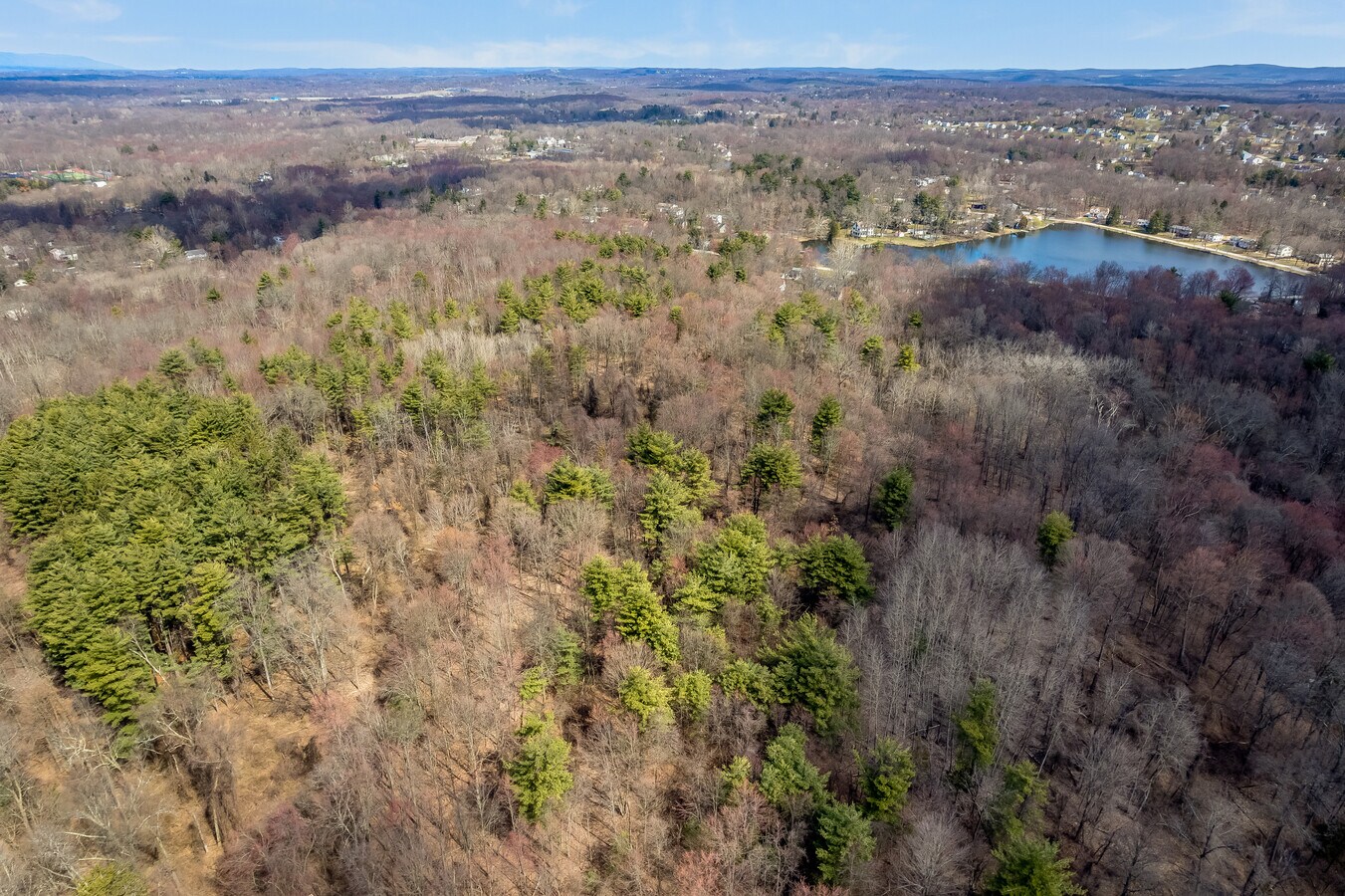
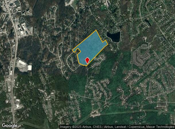
Property Record
Spook Hill Rd, Wappingers Falls, NY 12590

NEARBY LISTINGS FOR SALE OR LEASE
Property Detail
Spook Hill Rd
Dutchess County-Putnam County, NY
89.5 AC 1579 0680 1464 0245
135689-6257-01-260870-0000
Dutchess
Residentialacreage
New York
A
260
36027C0459E
89.50 AC
2023
Fishkill
2023
Westchester/So Connecticut
190203
DEMOGRAPHICS near Spook Hill Rd
1 Mile
3 Mile
5 Mile
2024 Total Population
5,147
34,153
75,117
2029 Population
5,142
34,067
74,855
Pop Growth 2024-2029
(0.10%)
(0.25%)
(0.35%)
Average Age
44
43
43
2024 Total Households
2,146
13,117
28,817
HH Growth 2024-2029
(0.14%)
(0.27%)
(0.38%)
Median Household Inc
$91,523
$93,891
$98,023
Avg Household Size
2.40
2.50
2.50
2024 Avg HH Vehicles
2.00
2.00
2.00
Median Home Value
$341,964
$344,820
$355,382
Median Year Built
1977
1967
1970
Nearby Places
- Restaurants
- Banks
- Shops
- Fitness
- Groceries
PUBLIC TRANSPORTATION
COMMUTER RAIL
New Hamburg Station (Hudson Line - Metro-North Commuter Railroad Company (Metro-North))
DRIVE
WALK
Distance
New Hamburg Station (Hudson Line - Metro-North Commuter Railroad Company (Metro-North))
10 min
4.0 mi
AIRPORT
New York Stewart International
DRIVE
WALK
Distance
New York Stewart International
32 min
18.9 mi
Freight Ports
Port of New Haven
DRIVE
WALK
Distance
Port of New Haven
101 min
72.9 mi
Nearby Properties
Address
Land Use
TOTAL SIZE
Lot Size
Zoning
Address
Land Use
TOTAL SIZE
Lot Size
Zoning
293,984 SF
47.95 AC
RMF5
Address
Land Use
TOTAL SIZE
Lot Size
Zoning
800 SF
10.21 AC
R1
Address
Land Use
TOTAL SIZE
Lot Size
Zoning
197,820 SF
56.20 AC
R20
Address
Land Use
TOTAL SIZE
Lot Size
Zoning
535,543 SF
72.62 AC
BSC
Address
Land Use
TOTAL SIZE
Lot Size
Zoning
143,274 SF
31.04 AC
R20/40
Address
Land Use
TOTAL SIZE
Lot Size
Zoning
104,800 SF
17.20 AC
R20
Address
Land Use
TOTAL SIZE
Lot Size
Zoning
151,698 SF
22.50 AC
PI
Address
Land Use
TOTAL SIZE
Lot Size
Zoning
40,030 SF
4.50 AC
HB
Address
Land Use
TOTAL SIZE
Lot Size
Zoning
211,760 SF
86.81 AC
SC
Address
Land Use
TOTAL SIZE
Lot Size
Zoning
32,920 SF
21.55 AC
CB-30
Address
Land Use
TOTAL SIZE
Lot Size
Zoning
105,500 SF
8.50 AC
RB
Address
Land Use
TOTAL SIZE
Lot Size
Zoning
98,700 SF
10 AC
BSC
Address
Land Use
TOTAL SIZE
Lot Size
Zoning
Address
Land Use
TOTAL SIZE
Lot Size
Zoning
Address
Land Use
TOTAL SIZE
Lot Size
Zoning
106,025 SF
7.20 AC
RM2
Address
Land Use
TOTAL SIZE
Lot Size
Zoning
192,321 SF
12.98 AC
SC
Address
Land Use
TOTAL SIZE
Lot Size
Zoning
54,595 SF
11 AC
R15
Address
Land Use
TOTAL SIZE
Lot Size
Zoning
103,422 SF
9.16 AC
CB-30
Address
Land Use
TOTAL SIZE
Lot Size
Zoning
42,052 SF
4.64 AC
BH
Address
Land Use
TOTAL SIZE
Lot Size
Zoning
56,824 SF
10 AC
RMF5
Address
Land Use
TOTAL SIZE
Lot Size
Zoning
Address
Land Use
TOTAL SIZE
Lot Size
Zoning
54,326 SF
12.82 AC
HB
Address
Land Use
TOTAL SIZE
Lot Size
Zoning
11.55 AC
R1
Address
Land Use
TOTAL SIZE
Lot Size
Zoning
93,440 SF
9.99 AC
BSC
Address
Land Use
TOTAL SIZE
Lot Size
Zoning
95,648 SF
8.59 AC
CB-32
Address
Land Use
TOTAL SIZE
Lot Size
Zoning
22 AC
R40
Address
Land Use
TOTAL SIZE
Lot Size
Zoning
116,592 SF
3.40 AC
RM5
Address
Land Use
TOTAL SIZE
Lot Size
Zoning
116,592 SF
3.60 AC
RM2
Address
Land Use
TOTAL SIZE
Lot Size
Zoning
59,033 SF
87.70 AC
IN
Address
Land Use
TOTAL SIZE
Lot Size
Zoning
81,194 SF
7 AC
CB-30
The World's #1 Commercial Real Estate Marketplace
Connect with us
© 2025 CoStar Group
The information above has been obtained from sources believed reliable. While we do not doubt its accuracy we have not verified it and make no guarantee, warranty or representation about it. It is your responsibility to independently confirm its accuracy and completeness. Any projections, opinions, assumptions, or estimates used are for example only and do not represent the current or future performance of the property. The value of this transaction to you depends on tax and other factors which should be evaluated by your tax, financial, and legal advisors. You and your advisors should conduct a careful, independent investigation of the property to determine to your satisfaction the suitability of the property for your needs.