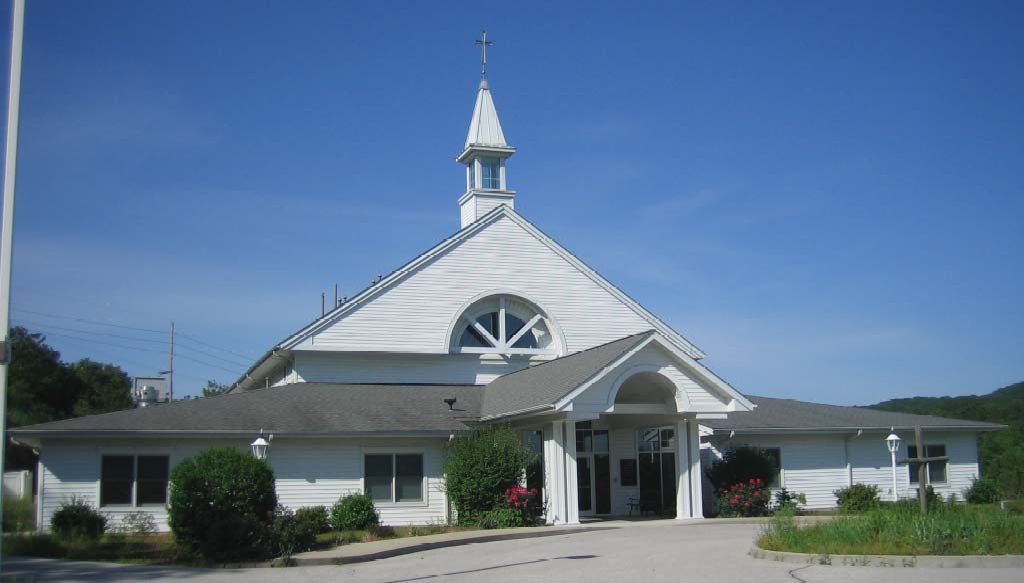
Property Record
4848 State Route 30, House Springs, MO 63051
NEARBY LISTINGS FOR SALE OR LEASE
-
-
View all House Springs listings for sale on LoopNet.com
Property Detail
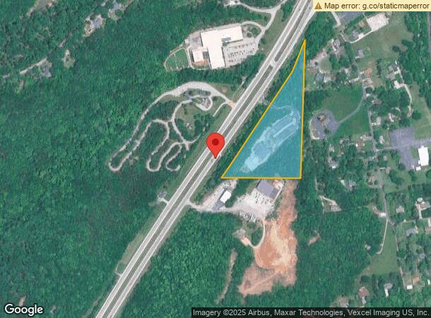
4848 State Route 30
St. Louis, MO-IL
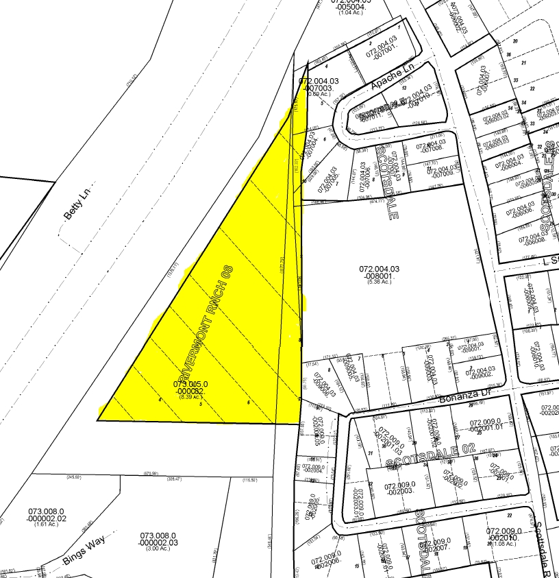
Rivermont Ranch 08
07-3.0-05.0-0-000-082
PT SE1/4 SE1/4
Miscellaneous
Jefferson
A
Missouri
29099C0089F
1
0
7.91 AC
2023
Jefferson County
700504
St. Louis
DEMOGRAPHICS near 4848 State Route 30
1 Mile
3 Mile
5 Mile
2024 Total Population
700
7,939
25,377
2029 Population
729
8,234
26,324
Pop Growth 2024-2029
+ 4.14%
+ 3.72%
+ 3.73%
Average Age
45
42
41
2024 Total Households
293
3,054
9,718
HH Growth 2024-2029
+ 4.10%
+ 3.83%
+ 3.82%
Median Household Inc
$65,500
$75,369
$72,055
Avg Household Size
2.40
2.60
2.60
2024 Avg HH Vehicles
2.00
2.00
2.00
Median Home Value
$250,000
$226,985
$209,126
Median Year Built
1975
1987
1984
Nearby Places
- Restaurants
- Banks
- Shops
- Fitness
- Groceries
PUBLIC TRANSPORTATION
AIRPORT
St Louis Lambert International
DRIVE
WALK
Distance
St Louis Lambert International
49 min
34.9 mi
Freight Ports
Tulsa Port of Inola
DRIVE
WALK
Distance
Tulsa Port of Inola
402 min
359.2 mi
SALE & LEASE HISTORY
LISTING DATE
SALE/LEASE

Sep 24, 2016
For Sale
Nearby Properties
Address
Land Use
TOTAL SIZE
Lot Size
Zoning
Address
Land Use
TOTAL SIZE
Lot Size
Zoning
760 SF
1.16 AC
R40
Address
Land Use
TOTAL SIZE
Lot Size
Zoning
56,840 SF
6.14 AC
CC2
Address
Land Use
TOTAL SIZE
Lot Size
Zoning
15,035 SF
2.57 AC
CT1
Address
Land Use
TOTAL SIZE
Lot Size
Zoning
8,099 SF
0.99 AC
Address
Land Use
TOTAL SIZE
Lot Size
Zoning
19,980 SF
3.22 AC
CC2
Address
Land Use
TOTAL SIZE
Lot Size
Zoning
1.06 AC
Address
Land Use
TOTAL SIZE
Lot Size
Zoning
12,323 SF
1.28 AC
CC2
Address
Land Use
TOTAL SIZE
Lot Size
Zoning
31,476 SF
4.15 AC
CT1
Address
Land Use
TOTAL SIZE
Lot Size
Zoning
2,880 SF
8.23 AC
CT1
Address
Land Use
TOTAL SIZE
Lot Size
Zoning
4,683 SF
1.87 AC
CC2
Address
Land Use
TOTAL SIZE
Lot Size
Zoning
5,212 SF
1.90 AC
CC2
Address
Land Use
TOTAL SIZE
Lot Size
Zoning
9,301 SF
0.95 AC
CC2
Address
Land Use
TOTAL SIZE
Lot Size
Zoning
44,104 SF
4.78 AC
R10
Address
Land Use
TOTAL SIZE
Lot Size
Zoning
15,660 SF
3.01 AC
Address
Land Use
TOTAL SIZE
Lot Size
Zoning
7,360 SF
0.93 AC
Address
Land Use
TOTAL SIZE
Lot Size
Zoning
3,788 SF
1.08 AC
Address
Land Use
TOTAL SIZE
Lot Size
Zoning
36,096 SF
3.48 AC
Address
Land Use
TOTAL SIZE
Lot Size
Zoning
6,120 SF
10.20 AC
CC2
Address
Land Use
TOTAL SIZE
Lot Size
Zoning
3,195 SF
0.99 AC
Address
Land Use
TOTAL SIZE
Lot Size
Zoning
3,362 SF
1.07 AC
CC2
Address
Land Use
TOTAL SIZE
Lot Size
Zoning
6,543 SF
0.79 AC
CC2
Address
Land Use
TOTAL SIZE
Lot Size
Zoning
5,200 SF
10.21 AC
LR2
Address
Land Use
TOTAL SIZE
Lot Size
Zoning
8,329 SF
435.87 AC
LR2
Address
Land Use
TOTAL SIZE
Lot Size
Zoning
2,755 SF
0.57 AC
CC2
Address
Land Use
TOTAL SIZE
Lot Size
Zoning
16,200 SF
116.38 AC
R40
Address
Land Use
TOTAL SIZE
Lot Size
Zoning
4,136 SF
15.68 AC
Address
Land Use
TOTAL SIZE
Lot Size
Zoning
3,690 SF
1.38 AC
CT1
Address
Land Use
TOTAL SIZE
Lot Size
Zoning
3,568 SF
0.47 AC
CC2
Address
Land Use
TOTAL SIZE
Lot Size
Zoning
2,097 SF
0.69 AC
CT1
The World's #1 Commercial Real Estate Marketplace
Connect with us
© 2025 CoStar Group
The information above has been obtained from sources believed reliable. While we do not doubt its accuracy we have not verified it and make no guarantee, warranty or representation about it. It is your responsibility to independently confirm its accuracy and completeness. Any projections, opinions, assumptions, or estimates used are for example only and do not represent the current or future performance of the property. The value of this transaction to you depends on tax and other factors which should be evaluated by your tax, financial, and legal advisors. You and your advisors should conduct a careful, independent investigation of the property to determine to your satisfaction the suitability of the property for your needs.