Property Record
37660 W 95Th St, De Soto, KS 66018
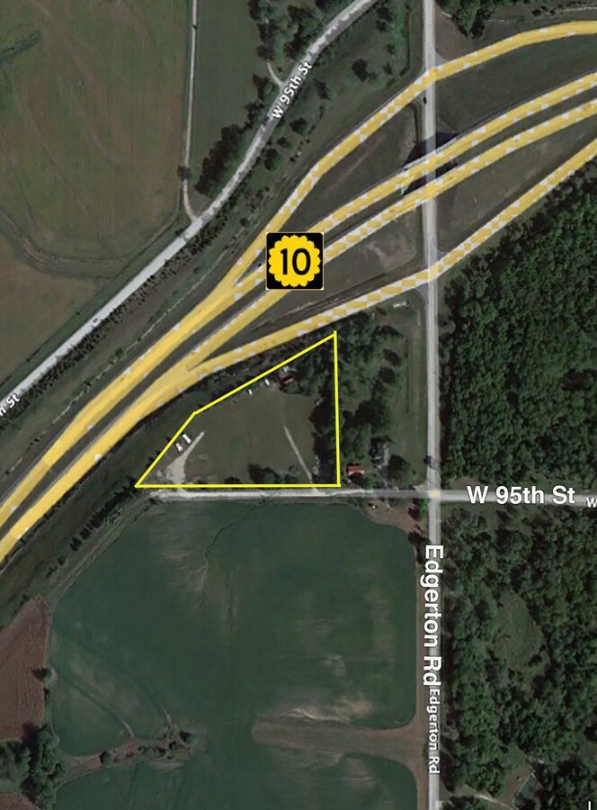
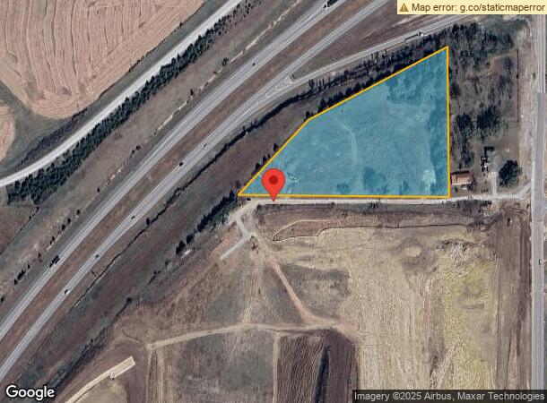
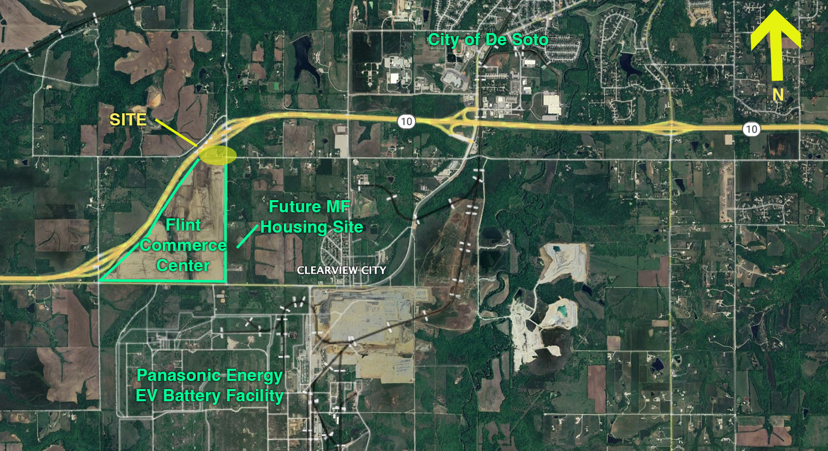
This Property Is For Sale
NEARBY LISTINGS FOR SALE OR LEASE
-
-
View all De Soto listings for sale on LoopNet.com
Property Detail
37660 W 95Th St
3F211236-4001
36-12-21 SE1/4 EX E 330 S 528 & EX 31.60 AC M/L IN HWY & EX PT LYING N & NW NW RTWY/LK-10 HWY 5.18 ACS M/L LE 57
Farms
Johnson
X
Kansas
20103C0400G
4.86 AC
2023
South Johnson County
2023
Kansas City
052702
Kansas City, MO-KS
DEMOGRAPHICS near 37660 W 95Th St
1 Mile
3 Mile
5 Mile
2024 Total Population
120
4,059
14,058
2029 Population
126
4,273
14,511
Pop Growth 2024-2029
+ 5.00%
+ 5.27%
+ 3.22%
Average Age
40
39
39
2024 Total Households
44
1,475
5,129
HH Growth 2024-2029
+ 4.55%
+ 5.36%
+ 3.35%
Median Household Inc
$42,500
$81,918
$87,956
Avg Household Size
2.70
2.70
2.70
2024 Avg HH Vehicles
2.00
2.00
2.00
Median Home Value
$372,727
$378,787
$297,659
Median Year Built
1987
1988
1991
Nearby Places
- Restaurants
- Banks
- Shops
- Fitness
- Groceries
PUBLIC TRANSPORTATION
AIRPORT
Kansas City International
DRIVE
WALK
Distance
Kansas City International
56 min
48.9 mi
Freight Ports
Tulsa Port Of Catoosa
DRIVE
WALK
Distance
Tulsa Port Of Catoosa
265 min
223.7 mi
Nearby Properties
Address
Land Use
TOTAL SIZE
Lot Size
Zoning
Address
Land Use
TOTAL SIZE
Lot Size
Zoning
261,124 SF
28.29 AC
O-I
Address
Land Use
TOTAL SIZE
Lot Size
Zoning
17,561 SF
6.91 AC
M-1
Address
Land Use
TOTAL SIZE
Lot Size
Zoning
186,690 SF
30.21 AC
O-I
Address
Land Use
TOTAL SIZE
Lot Size
Zoning
86,459 SF
17.20 AC
O-I
Address
Land Use
TOTAL SIZE
Lot Size
Zoning
3,416 SF
3.20 AC
M-1
Address
Land Use
TOTAL SIZE
Lot Size
Zoning
296,779 SF
146 AC
M-1
Address
Land Use
TOTAL SIZE
Lot Size
Zoning
436,551 SF
52.90 AC
M-1
Address
Land Use
TOTAL SIZE
Lot Size
Zoning
35,725 SF
9.52 AC
R-0
Address
Land Use
TOTAL SIZE
Lot Size
Zoning
37.03 AC
RUR
Address
Land Use
TOTAL SIZE
Lot Size
Zoning
5,000 SF
20.03 AC
RUR
Address
Land Use
TOTAL SIZE
Lot Size
Zoning
16,868 SF
2.61 AC
C-2
Address
Land Use
TOTAL SIZE
Lot Size
Zoning
26.12 AC
RUR
Address
Land Use
TOTAL SIZE
Lot Size
Zoning
10,620 SF
5.85 AC
R-1
Address
Land Use
TOTAL SIZE
Lot Size
Zoning
18,000 SF
3.38 AC
M-1
Address
Land Use
TOTAL SIZE
Lot Size
Zoning
77,519 SF
15.20 AC
M-1
Address
Land Use
TOTAL SIZE
Lot Size
Zoning
46,024 SF
3.64 AC
M-1
Address
Land Use
TOTAL SIZE
Lot Size
Zoning
37,081 SF
5.46 AC
M-1
Address
Land Use
TOTAL SIZE
Lot Size
Zoning
45,350 SF
3.11 AC
P-D
Address
Land Use
TOTAL SIZE
Lot Size
Zoning
92,851 SF
69.30 AC
RLD
Address
Land Use
TOTAL SIZE
Lot Size
Zoning
44.59 AC
RN1
Address
Land Use
TOTAL SIZE
Lot Size
Zoning
30,240 SF
3 AC
O-I
Address
Land Use
TOTAL SIZE
Lot Size
Zoning
2,970 SF
1.01 AC
C2
Address
Land Use
TOTAL SIZE
Lot Size
Zoning
11.69 AC
RUR
Address
Land Use
TOTAL SIZE
Lot Size
Zoning
39,185 SF
4.01 AC
P-D
Address
Land Use
TOTAL SIZE
Lot Size
Zoning
4,398 SF
1.67 AC
M-1
Address
Land Use
TOTAL SIZE
Lot Size
Zoning
4,360 SF
0.91 AC
RUR
Address
Land Use
TOTAL SIZE
Lot Size
Zoning
87,820 SF
164.92 AC
M-1
Address
Land Use
TOTAL SIZE
Lot Size
Zoning
10,920 SF
1.40 AC
C-2
Address
Land Use
TOTAL SIZE
Lot Size
Zoning
4,376 SF
0.96 AC
C-2
Address
Land Use
TOTAL SIZE
Lot Size
Zoning
14,116 SF
1.82 AC
M-1
The World's #1 Commercial Real Estate Marketplace
Connect with us
© 2025 CoStar Group
The information above has been obtained from sources believed reliable. While we do not doubt its accuracy we have not verified it and make no guarantee, warranty or representation about it. It is your responsibility to independently confirm its accuracy and completeness. Any projections, opinions, assumptions, or estimates used are for example only and do not represent the current or future performance of the property. The value of this transaction to you depends on tax and other factors which should be evaluated by your tax, financial, and legal advisors. You and your advisors should conduct a careful, independent investigation of the property to determine to your satisfaction the suitability of the property for your needs.