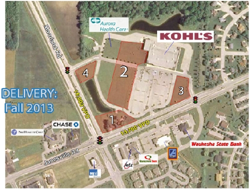
Property Record
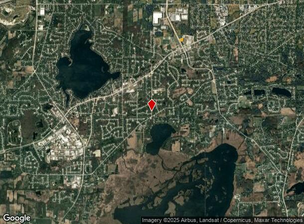
W156s6840 Moorland Rd, Muskego, WI 53150
NEARBY LISTINGS FOR SALE OR LEASE
Property Detail
W156s6840 Moorland Rd
Milwaukee-Waukesha-West Allis, WI
Certified Surv Map 9335
MSKC-2167-995-010
PARCEL 4 CERT SURV 9335 VOL 84/352 REC AS DOC# 2773946 REDIV LOT 1 & LOT 2 CSM 9127 PT NW1/4 & SW1/4 OF SW1/4 SEC 2 & NE1/4 OF SE1/4 SEC 3 T5N R20E :: DOC# 4051415
Commercialnec
Waukesha
X
Wisconsin
55133C0361H
1,2
2023
0.74 AC
2023
SE/Muskego
201703
Milwaukee/Madison
DEMOGRAPHICS near W156s6840 Moorland Rd
1 Mile
3 Mile
5 Mile
2024 Total Population
3,080
31,865
83,627
2029 Population
3,076
32,272
84,298
Pop Growth 2024-2029
(0.13%)
+ 1.28%
+ 0.80%
Average Age
44
44
45
2024 Total Households
1,253
12,648
34,718
HH Growth 2024-2029
(0.16%)
+ 1.23%
+ 0.73%
Median Household Inc
$96,646
$101,586
$96,000
Avg Household Size
2.40
2.50
2.40
2024 Avg HH Vehicles
2.00
2.00
2.00
Median Home Value
$381,904
$338,545
$330,531
Median Year Built
1985
1979
1982
Nearby Places
- Restaurants
- Banks
- Shops
- Fitness
- Groceries
PUBLIC TRANSPORTATION
AIRPORT
General Mitchell International
DRIVE
WALK
Distance
General Mitchell International
28 min
13.8 mi
Freight Ports
Port Milwaukee
DRIVE
WALK
Distance
Port Milwaukee
27 min
15.7 mi
SALE & LEASE HISTORY
LISTING DATE
SALE/LEASE

Apr 25, 2017
For Lease
Apr 25, 2017
For Sale
Apr 11, 2017
For Sale
Nearby Properties
Address
Land Use
TOTAL SIZE
Lot Size
Zoning
Address
Land Use
TOTAL SIZE
Lot Size
Zoning
464,768 SF
34.90 AC
M1
Address
Land Use
TOTAL SIZE
Lot Size
Zoning
33.26 AC
Address
Land Use
TOTAL SIZE
Lot Size
Zoning
18.54 AC
Address
Land Use
TOTAL SIZE
Lot Size
Zoning
Address
Land Use
TOTAL SIZE
Lot Size
Zoning
Address
Land Use
TOTAL SIZE
Lot Size
Zoning
15.88 AC
Address
Land Use
TOTAL SIZE
Lot Size
Zoning
Address
Land Use
TOTAL SIZE
Lot Size
Zoning
Address
Land Use
TOTAL SIZE
Lot Size
Zoning
200,160 SF
11.44 AC
M1
Address
Land Use
TOTAL SIZE
Lot Size
Zoning
Address
Land Use
TOTAL SIZE
Lot Size
Zoning
Address
Land Use
TOTAL SIZE
Lot Size
Zoning
5.14 AC
Address
Land Use
TOTAL SIZE
Lot Size
Zoning
100,939 SF
8.97 AC
M1
Address
Land Use
TOTAL SIZE
Lot Size
Zoning
110,101 SF
8.51 AC
M1
Address
Land Use
TOTAL SIZE
Lot Size
Zoning
Address
Land Use
TOTAL SIZE
Lot Size
Zoning
132,478 SF
13.29 AC
M1
Address
Land Use
TOTAL SIZE
Lot Size
Zoning
56,104 SF
8.52 AC
M1
Address
Land Use
TOTAL SIZE
Lot Size
Zoning
7.40 AC
Address
Land Use
TOTAL SIZE
Lot Size
Zoning
11.38 AC
Address
Land Use
TOTAL SIZE
Lot Size
Zoning
9.16 AC
M1
Address
Land Use
TOTAL SIZE
Lot Size
Zoning
8.59 AC
M1
Address
Land Use
TOTAL SIZE
Lot Size
Zoning
93,776 SF
7.95 AC
M1
Address
Land Use
TOTAL SIZE
Lot Size
Zoning
Address
Land Use
TOTAL SIZE
Lot Size
Zoning
Address
Land Use
TOTAL SIZE
Lot Size
Zoning
6.58 AC
M1
Address
Land Use
TOTAL SIZE
Lot Size
Zoning
Address
Land Use
TOTAL SIZE
Lot Size
Zoning
Address
Land Use
TOTAL SIZE
Lot Size
Zoning
Address
Land Use
TOTAL SIZE
Lot Size
Zoning
Address
Land Use
TOTAL SIZE
Lot Size
Zoning
The World's #1 Commercial Real Estate Marketplace
Connect with us
© 2025 CoStar Group
The information above has been obtained from sources believed reliable. While we do not doubt its accuracy we have not verified it and make no guarantee, warranty or representation about it. It is your responsibility to independently confirm its accuracy and completeness. Any projections, opinions, assumptions, or estimates used are for example only and do not represent the current or future performance of the property. The value of this transaction to you depends on tax and other factors which should be evaluated by your tax, financial, and legal advisors. You and your advisors should conduct a careful, independent investigation of the property to determine to your satisfaction the suitability of the property for your needs.