Property Record
Winn Rd, El Paso, TX 79927
NEARBY LISTINGS FOR SALE OR LEASE
Property Detail
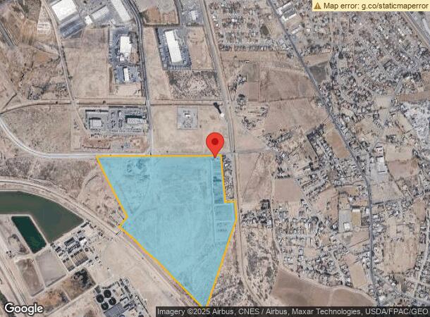
Winn Rd
El Paso
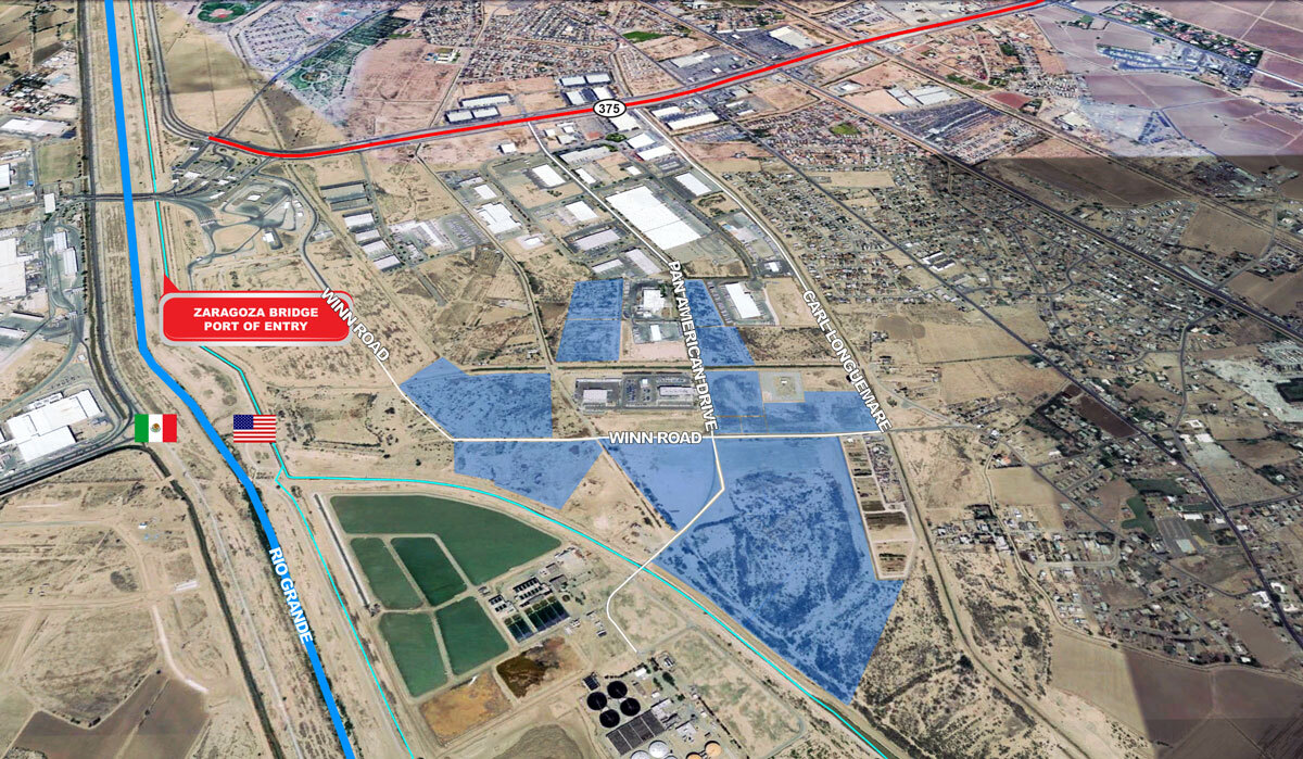
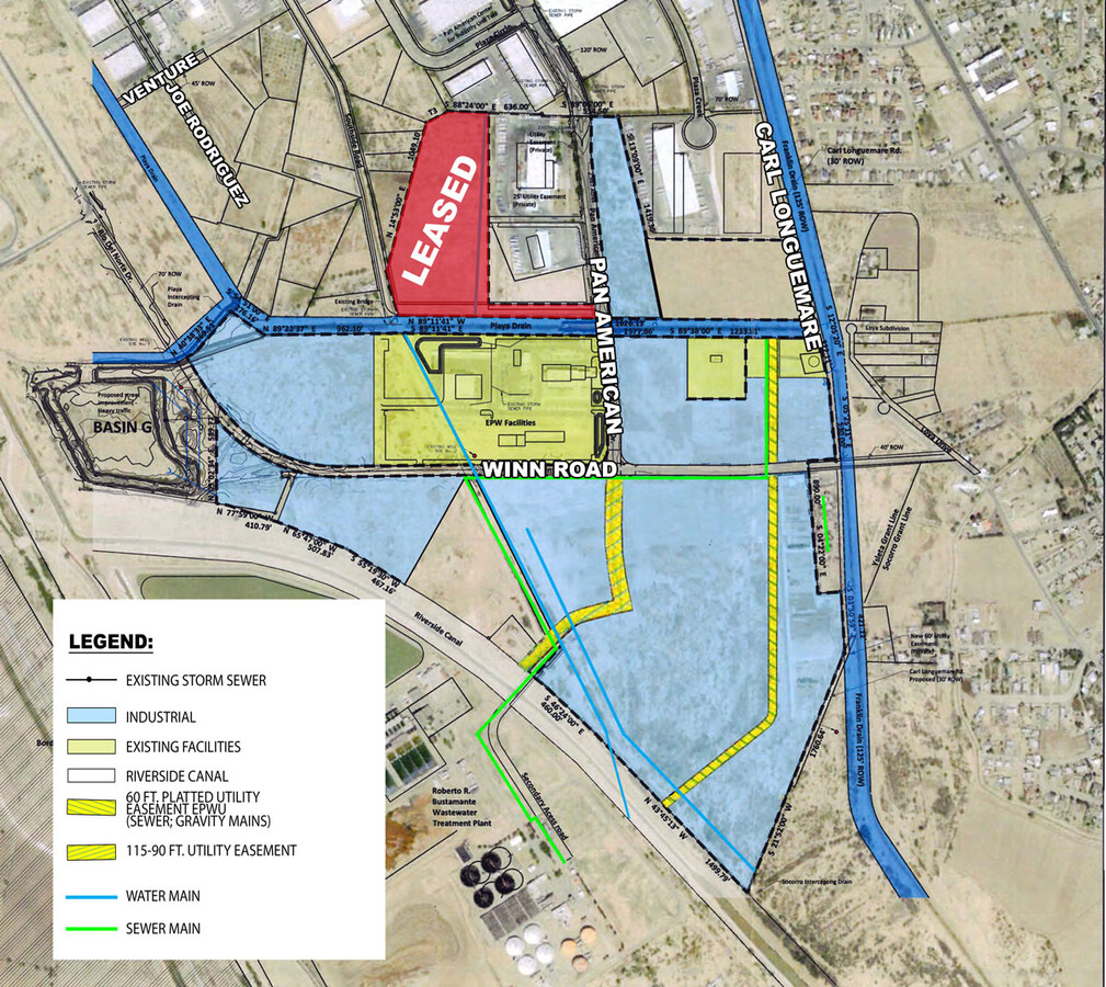
Riverside Intl Industrial Cntr
El Paso, TX
5 RIVERSIDE INTL INDUSTRIAL CNTR LOT 1 (101.0470 AC)
R610-999-0050-0100
El Paso
Governmentalpublicusegeneral
Texas
2023
1
2023
101.05 AC
004002
East
DEMOGRAPHICS near Winn Rd
1 Mile
3 Mile
5 Mile
2024 Total Population
2,919
39,152
103,467
2029 Population
2,921
39,463
104,937
Pop Growth 2024-2029
+ 0.07%
+ 0.79%
+ 1.42%
Average Age
39
38
37
2024 Total Households
935
12,578
33,440
HH Growth 2024-2029
0.00%
+ 0.76%
+ 1.35%
Median Household Inc
$38,373
$39,631
$43,071
Avg Household Size
3.10
3.10
3.00
2024 Avg HH Vehicles
2.00
2.00
2.00
Median Home Value
$109,434
$105,863
$124,224
Median Year Built
1984
1985
1988
Nearby Places
- Restaurants
- Banks
- Shops
- Fitness
- Groceries
PUBLIC TRANSPORTATION
AIRPORT
El Paso International
DRIVE
WALK
Distance
El Paso International
31 min
15.2 mi
Freight Ports
Port of Corpus Christi
DRIVE
WALK
Distance
Port of Corpus Christi
668 min
681.6 mi
SALE & LEASE HISTORY
LISTING DATE
SALE/LEASE

Oct 09, 2018
For Lease
Nearby Properties
Address
Land Use
TOTAL SIZE
Lot Size
Zoning
Address
Land Use
TOTAL SIZE
Lot Size
Zoning
393,206 SF
66.48 AC
SU
Address
Land Use
TOTAL SIZE
Lot Size
Zoning
89,251 SF
9.39 AC
AM
Address
Land Use
TOTAL SIZE
Lot Size
Zoning
127,840 SF
17.66 AC
Address
Land Use
TOTAL SIZE
Lot Size
Zoning
657,494 SF
36.94 AC
M1S
Address
Land Use
TOTAL SIZE
Lot Size
Zoning
129,165 SF
13.17 AC
A2
Address
Land Use
TOTAL SIZE
Lot Size
Zoning
74,691 SF
53.62 AC
M1
Address
Land Use
TOTAL SIZE
Lot Size
Zoning
179,391 SF
8.23 AC
SD
Address
Land Use
TOTAL SIZE
Lot Size
Zoning
226,638 SF
27.25 AC
C3S
Address
Land Use
TOTAL SIZE
Lot Size
Zoning
84,207 SF
20 AC
Address
Land Use
TOTAL SIZE
Lot Size
Zoning
347,235 SF
33.50 AC
A2
Address
Land Use
TOTAL SIZE
Lot Size
Zoning
43,663 SF
15.70 AC
A2
Address
Land Use
TOTAL SIZE
Lot Size
Zoning
41,778 SF
4.37 AC
A2S
Address
Land Use
TOTAL SIZE
Lot Size
Zoning
33,792 SF
9.42 AC
RF
Address
Land Use
TOTAL SIZE
Lot Size
Zoning
90,432 SF
4.05 AC
C1S
Address
Land Use
TOTAL SIZE
Lot Size
Zoning
210,863 SF
10 AC
M1S
Address
Land Use
TOTAL SIZE
Lot Size
Zoning
55,740 SF
19.26 AC
RF
Address
Land Use
TOTAL SIZE
Lot Size
Zoning
177,370 SF
10.46 AC
C4
Address
Land Use
TOTAL SIZE
Lot Size
Zoning
101,700 SF
10 AC
M1
Address
Land Use
TOTAL SIZE
Lot Size
Zoning
45,091 SF
5.25 AC
Address
Land Use
TOTAL SIZE
Lot Size
Zoning
155,725 SF
7.65 AC
C4C
Address
Land Use
TOTAL SIZE
Lot Size
Zoning
99,000 SF
5.10 AC
C4C
Address
Land Use
TOTAL SIZE
Lot Size
Zoning
136,494 SF
8.62 AC
C4C
Address
Land Use
TOTAL SIZE
Lot Size
Zoning
109,666 SF
11.43 AC
M1S
Address
Land Use
TOTAL SIZE
Lot Size
Zoning
82,683 SF
8.86 AC
C4S
Address
Land Use
TOTAL SIZE
Lot Size
Zoning
165,600 SF
12.63 AC
M1S
Address
Land Use
TOTAL SIZE
Lot Size
Zoning
82,571 SF
8.43 AC
C1S
Address
Land Use
TOTAL SIZE
Lot Size
Zoning
119,712 SF
7.55 AC
C3S
Address
Land Use
TOTAL SIZE
Lot Size
Zoning
50,744 SF
5.83 AC
R3
Address
Land Use
TOTAL SIZE
Lot Size
Zoning
125,877 SF
9.92 AC
C4
Address
Land Use
TOTAL SIZE
Lot Size
Zoning
35,577 SF
4.75 AC
C3
The World's #1 Commercial Real Estate Marketplace
Connect with us
© 2025 CoStar Group
The information above has been obtained from sources believed reliable. While we do not doubt its accuracy we have not verified it and make no guarantee, warranty or representation about it. It is your responsibility to independently confirm its accuracy and completeness. Any projections, opinions, assumptions, or estimates used are for example only and do not represent the current or future performance of the property. The value of this transaction to you depends on tax and other factors which should be evaluated by your tax, financial, and legal advisors. You and your advisors should conduct a careful, independent investigation of the property to determine to your satisfaction the suitability of the property for your needs.